| Home | City Bus | Maps | Villages | Cities | Rail | Tourist Places | School | College | Pin Codes | Corona Cases Count |
| Distance Calculator Bus Services IFSC Codes Trace Mobile Number Weather Search Place Trace IP Available Cash ATM/Banks Locate Polling Booth Report an Error contact People |
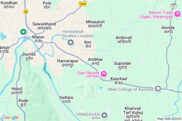
Ambhai
Ambhai Map
EDIT Map
Add Your House
 ..
..
Current Corona Virus Infected Patients Count in Thane District
| City Name | District Name | Total Covid cases |
|---|---|---|
| Thane | Thane | 108 |
| Navi Mumbai | Thane | 70 |
| Thane District | Thane | 67 |
| Mira-Bhayandar | Thane | 53 |
| Kalyan-Dombivali | Thane | 50 |
| Thane Rural | Thane | 29 |
| MBMC | Thane | 11 |
| Thane Corp | Thane | 6 |
| KDMC | Thane | 5 |
| Bhiwandi | Thane | 4 |
| Ulhasnagar | Thane | 1 |
| Thane - Vashi | Thane | 1 |
Locality Name :
Ambhai
( अंभई )
Taluka Name : Wada
District : Thane
State : Maharashtra
Region : Konkan
Division : Konkan
Language : Marathi and Sindhi, Gujarati And Hindi
Current Time 12:22 PM
Date: Tuesday , Apr 29,2025 (IST)
Time zone: IST (UTC+5:30)
Elevation / Altitude: 102 meters. Above Seal level
Telephone Code / Std Code: 02526
Assembly constituency : Vikramgad assembly constituency
Assembly MLA : Bhusara Sunil Chandrakant
Lok Sabha constituency : Palghar parliamentary constituency
Parliament MP : Rajendra Dhedya Gavit
Serpanch Name :
Pin Code : 421303
Post Office Name : Wada
Commodities Prices : Vasai Market / Mandi
National Highways Reachable To Ambhai
Nationa High Way :NH160
Nationa High Way :NH48
Nationa High Way :NH160
Nationa High Way :NH48
Rivers Near Ambhai
Vaitarna River
Vaitarna
Vaitarna River
Vaitarna
About Ambhai
Correct below Info and add more info about AmbhaiAmbhai is a Village in Wada Taluka in Thane District of Maharashtra State, India. It belongs to Konkan region . It belongs to Konkan Division . It is located 59 KM towards North from District head quarters Thane. 17 KM from Wada. 90 KM from State capital Mumbai
Ambhai Pin code is 421303 and postal head office is Wada .
Suponde ( 3 KM ) , Kanchad ( 4 KM ) , Kurnze ( 4 KM ) , Shelte ( 4 KM ) , Guhir ( 5 KM ) are the nearby Villages to Ambhai. Ambhai is surrounded by Wada Taluka towards East , Palghar Taluka towards west , Virar Taluka towards South , Dahanu Taluka towards west .
Palghar , Virar , Nawapur , Nalasopara are the near by Cities to Ambhai.
Ambhai 2011 Census Details
Ambhai Local Language is Marathi. Ambhai Village Total population is 596 and number of houses are 119. Female Population is 50.8%. Village literacy rate is 64.8% and the Female Literacy rate is 29.9%.
Population
| Census Parameter | Census Data |
| Total Population | 596 |
| Total No of Houses | 119 |
| Female Population % | 50.8 % ( 303) |
| Total Literacy rate % | 64.8 % ( 386) |
| Female Literacy rate | 29.9 % ( 178) |
| Scheduled Tribes Population % | 53.9 % ( 321) |
| Scheduled Caste Population % | 1.3 % ( 8) |
| Working Population % | 50.3 % |
| Child(0 -6) Population by 2011 | 84 |
| Girl Child(0 -6) Population % by 2011 | 46.4 % ( 39) |
Ambhai Census More Deatils.
Politics in Ambhai
BJP , NCP , Shivsena , BVA , SHS are the major political parties in this area.Polling Stations /Booths near Ambhai
1)Z.p.praimary School Suponda Room No.12)Z.p. Marathi School Zap Room No.1
3)Gramapanchayat Office Talavali Room No.1
4)Z.p.marathi School Botoshi Room No.1
5)Z.p.marathi School Dhadhari Room No.1
HOW TO REACH Ambhai
By Rail
There is no railway station near to Ambhai in less than 10 km. Bhiwandi Road Rail Way Station (near to Bhiwandi) , Thakurli Rail Way Station (near to Bhiwandi) , Palghar Rail Way Station (near to Palghar) , Umroli Rail Way Station (near to Palghar) are the Rail way stations reachable from near by towns.By Road
Jawhar , Palghar , Bhiwandi are the nearby by towns to Ambhai having road connectivity to AmbhaiColleges near Ambhai
Gurudev Chaitanyaswroop Highschool & Jr.college
Address :
Schools in Ambhai
Gurudev Chaitanya Swaroop High
Address : ambhai , wada , thane , Maharashtra . PIN- 421303 , Post - Wada
Govt Health Centers near Ambhai
1) Brahamangaon , SubCenter , AT- BRAHAMANGAON, POST- KANCHAD, TAL- WADA , NEAR KATAKARI PADA2) Khutal , SubCenter , AT- KHUTAL, POST- HAMARAPUR, TAL- WADA , NEAR HANUMAN MANDIR
3) Kanchad , SubCenter , AT. POST- KANCHAD, TAL- WADA , NEAR MARUI MANDIR
Sub Villages in Ambhai
Schools in Ambhai,Wada
Electronic Shops in Ambhai,Wada
Super Markets in Ambhai,Wada
Local Parks in Ambhai,Wada
Police Stations near Ambhai,Wada
Governement Offices near Ambhai,Wada
About Ambhai &
History
How to reach Ambhai
Tourist Places Near By Ambhai
Schools in Ambhai
Colleges in Ambhai
Temperature & weather of Ambhai
places in Ambhai
Ambhai photos
More Information
How to reach Ambhai
Tourist Places Near By Ambhai
Schools in Ambhai
Colleges in Ambhai
Temperature & weather of Ambhai
places in Ambhai
Ambhai photos
More Information
Village Talk
Post News or Events about this Village
Near Cities
Palghar 26 KM near
Virar 36 KM near
Nawapur 37 KM near
Nalasopara 38 KM near
Palghar 26 KM near
Virar 36 KM near
Nawapur 37 KM near
Nalasopara 38 KM near
Near By Taluks
Vikramgad 16 KM near
Wada 17 KM near
Palghar 21 KM near
Virar 38 KM near
Vikramgad 16 KM near
Wada 17 KM near
Palghar 21 KM near
Virar 38 KM near
Near By Air Ports
Chhatrapati Shivaji International Airport 76 KM near
Gandhinagar Airport 101 KM near
Lohegaon Airport 177 KM near
Bhavnagar Airport 272 KM near
Chhatrapati Shivaji International Airport 76 KM near
Gandhinagar Airport 101 KM near
Lohegaon Airport 177 KM near
Bhavnagar Airport 272 KM near
Near By Tourist Places
Vikramgad 39 KM near
Mahuli Fort 40 KM near
Dahanu 45 KM near
Khodala 49 KM near
Bordi 59 KM near
Vikramgad 39 KM near
Mahuli Fort 40 KM near
Dahanu 45 KM near
Khodala 49 KM near
Bordi 59 KM near
Near By Districts
Thane 56 KM near
Dadra And Nagar Haveli 71 KM near
Diu 90 KM near
Daman 90 KM near
Thane 56 KM near
Dadra And Nagar Haveli 71 KM near
Diu 90 KM near
Daman 90 KM near
Near By RailWay Station
Palghar Rail Way Station 25 KM near
Boisar Rail Way Station 29 KM near
Palghar Rail Way Station 25 KM near
Boisar Rail Way Station 29 KM near