| Home | City Bus | Maps | Villages | Cities | Rail | Tourist Places | School | College | Pin Codes | Corona Cases Count |
| Distance Calculator Bus Services IFSC Codes Trace Mobile Number Weather Search Place Trace IP Available Cash ATM/Banks Locate Polling Booth Report an Error contact People |
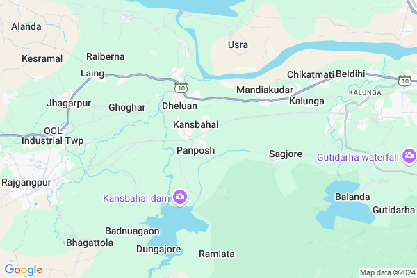
Panposh
Panposh Map
EDIT Map
Add Your House
 ..
..
Current Corona Virus Infected Patients Count in Sundargarh District
| City Name | District Name | Total Covid cases |
|---|---|---|
| Rourkela | Sundargarh | 3 |
| Sundargarh District | Sundargarh | 3 |
Locality Name :
Panposh
( ପାନପୋଷ )
Tehsil Name : Rajgangpur
District : Sundargarh
State : Odisha
Language : Oriya and Sundargadi
Current Time 09:20 AM
Date: Wednesday , Apr 30,2025 (IST)
Time zone: IST (UTC+5:30)
Elevation / Altitude: 237 meters. Above Seal level
Telephone Code / Std Code: 06624
Assembly constituency : Rajgangpur assembly constituency
Assembly MLA : mangala kisan
Lok Sabha constituency : Sundargarh parliamentary constituency
Parliament MP : Jual Oram
Serpanch Name :
Pin Code : 770034
Post Office Name : PIET Mandiakudar
Commodities Prices : Panposh Market / Mandi
Panposh Live Weather
Temperature: 23.7 °C
clear sky
Humidity: 60%
Wind : 1.09 mt/sec towards E
StationName : "BÄ\u0081nposh"
observed on 2 Hours Back
Temperature: 23.7 °C
clear sky
Humidity: 60%
Wind : 1.09 mt/sec towards E
StationName : "BÄ\u0081nposh"
observed on 2 Hours Back
Panposh Weather Forecast for Next 5 days
01-05-2025
21.8°C to 40.1°C
clear sky, few clouds, light rain
21.8°C to 40.1°C
clear sky, few clouds, light rain
02-05-2025
20.8°C to 38.8°C
clear sky, light rain, broken clouds, few clouds
20.8°C to 38.8°C
clear sky, light rain, broken clouds, few clouds
03-05-2025
20.6°C to 40.1°C
clear sky, light rain, broken clouds
20.6°C to 40.1°C
clear sky, light rain, broken clouds
04-05-2025
24.0°C to 41.2°C
broken clouds, few clouds, clear sky, light rain, scattered clouds
24.0°C to 41.2°C
broken clouds, few clouds, clear sky, light rain, scattered clouds
05-05-2025
24.7°C to 42.6°C
scattered clouds, clear sky, light rain, broken clouds
24.7°C to 42.6°C
scattered clouds, clear sky, light rain, broken clouds
National Highways Reachable To Panposh
Nationa High Way :NH320D
Nationa High Way :NH143
Nationa High Way :NH320D
Nationa High Way :NH143
Rivers Near Panposh
Kalia
Pada
Kalia
Pada
About Panposh
Correct below Info and add more info about PanposhPanposh is a Village in Rajgangpur Tehsil in Sundargarh District of Odisha State, India. It is located 77 KM towards East from District head quarters Sundargarh. 10 KM from Rajgangpur. 290 KM from State capital Bhubaneswar
Panposh Pin code is 770034 and postal head office is PIET Mandiakudar .
Laing ( 7 KM ) , Chikatmati ( 8 KM ) , Balanda ( 9 KM ) , Kesramal ( 10 KM ) , Rajgangpur ( 10 KM ) are the nearby Villages to Panposh. Panposh is surrounded by Kuarmunda Tehsil towards North , Lathikata Tehsil towards East , Raurkela Tehsil towards East , Biramitrapur Tehsil towards North .
Rajagangapur , Raurkela , Biramitrapur , Bamra are the near by Cities to Panposh.
Demographics of Panposh
Oriya is the Local Language here.Politics in Panposh
BJD , INC are the major political parties in this area.Polling Stations /Booths near Panposh
1)Kansbahal Bagichapara Pup School2)Kansbahal D.a.v.public School
3)Purkapali Upper Primary School
4)Govt. U.g. High Shool Panposh
5)Kandeimunda Primary School
HOW TO REACH Panposh
By Rail
Kanshbahal Rail Way Station , Kalunga Rail Way Station are the very nearby railway stations to Panposh.Colleges near Panposh
Kansbahal College Laing
Address :
Schools in Panposh
Sadhuram Jindal High School
Address : panposh , rajgangpur , sundergarh , Sikkim . PIN- 770017 , Post - Ranibandha
Panposh Nodal U.p. School
Address : panposh , rajgangpur , sundergarh , Sikkim . PIN- 770034 , Post - PIET Mandiakudar
Petrol Bunks in Panposh,Rajgangpur
MINZ AUTOMOBILES
SH10; KANSBAHAL; SUNDERGAR; Sundargarh; Odisha 760034; India
4.8 KM distance Detail
Maa Maheswari Filling Station Indian Oil Petrol Pump
Laing; Sundargarh; SH-10; Sambalpur Rourkela Road; Sundargarh; Sundargarh; Odisha 770034; India
5.1 KM distance Detail
more ..
Colleges in Panposh,Rajgangpur
Indian Institute For Production Management
SH 10; Kansbahal; Odisha 770034; India
2.5 KM distance Detail
more ..
Electronic Shops in Panposh,Rajgangpur
New Kanhaiya Mobile & E-carnar
22°13'42. 84°39'34.; 8; Rd Number 2; Vijayanagar; KIADB Export Promotion Industrial Area; Whitefield; Bengaluru; Karnataka 560066; India
2.7 KM distance Detail
Power King Electricals
Kansbahal - Ghoghar Baba Rd; Kansbahal; Odisha 770034; India
2.7 KM distance Detail
Super Markets in Panposh,Rajgangpur
AAYRA FOOTWEAR New Market Copelax Kalunga
Kalunga - Gurundia Rd; Kanshbahal; Rourkela; Odisha 770031; India
8.4 KM distance Detail
Police Stations near Panposh,Rajgangpur
Kansbahal Police Outpost
D3B/D3A; State Highway 10; Kansbahal; Odisha 770034; India
2.5 KM distance Detail
RGP Police Station
Rajgangpur Railway Colony; Rajgangpur; Odisha 770017; India
10.9 KM distance Detail
About Panposh &
History
How to reach Panposh
Tourist Places Near By Panposh
Schools in Panposh
Colleges in Panposh
Temperature & weather of Panposh
places in Panposh
Panposh photos
More Information
How to reach Panposh
Tourist Places Near By Panposh
Schools in Panposh
Colleges in Panposh
Temperature & weather of Panposh
places in Panposh
Panposh photos
More Information
Village Talk
Post News or Events about this Village
Near Cities
Rajagangapur 10 KM near
Raurkela 25 KM near
Biramitrapur 26 KM near
Bamra 47 KM near
Rajagangapur 10 KM near
Raurkela 25 KM near
Biramitrapur 26 KM near
Bamra 47 KM near
Near By Taluks
Rajgangpur 10 KM near
Kuarmunda 16 KM near
Lathikata 21 KM near
Raurkela 23 KM near
Rajgangpur 10 KM near
Kuarmunda 16 KM near
Lathikata 21 KM near
Raurkela 23 KM near
Near By Air Ports
Ranchi Airport 157 KM near
Bhubaneswar Airport 277 KM near
Gaya Airport 317 KM near
Raipur Airport 362 KM near
Ranchi Airport 157 KM near
Bhubaneswar Airport 277 KM near
Gaya Airport 317 KM near
Raipur Airport 362 KM near
Near By Tourist Places
Rourkela 25 KM near
Simdega 53 KM near
Jashpur 103 KM near
Gumla 105 KM near
Chotanagpur 106 KM near
Rourkela 25 KM near
Simdega 53 KM near
Jashpur 103 KM near
Gumla 105 KM near
Chotanagpur 106 KM near
Near By Districts
Simdega 54 KM near
Sundargarh 74 KM near
Deogarh 83 KM near
Jharsuguda 85 KM near
Simdega 54 KM near
Sundargarh 74 KM near
Deogarh 83 KM near
Jharsuguda 85 KM near
Near By RailWay Station
Kanshbahal Rail Way Station 0.7 KM near
Kalunga Rail Way Station 7.9 KM near
Rajgangpur Rail Way Station 10 KM near
Rourkela Junction Rail Way Station 22 KM near
Kanshbahal Rail Way Station 0.7 KM near
Kalunga Rail Way Station 7.9 KM near
Rajgangpur Rail Way Station 10 KM near
Rourkela Junction Rail Way Station 22 KM near