| Home | City Bus | Maps | Villages | Cities | Rail | Tourist Places | School | College | Pin Codes | Corona Cases Count |
| Distance Calculator Bus Services IFSC Codes Trace Mobile Number Weather Search Place Trace IP Available Cash ATM/Banks Locate Polling Booth Report an Error contact People |
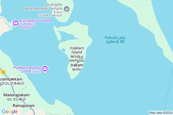
Irakam
Irakam Map
EDIT Map
Add Your House
 ..
..
Current Corona Virus Infected Patients Count in Spsr Nellore District
| City Name | District Name | Total Covid cases |
|---|---|---|
| S.P.S. Nellore District | S.P.S. Nellore | 49 |
| Nellore | S.P.S. Nellore | 5 |
| Naidupeta | S.P.S. Nellore | 3 |
| Tada | S.P.S. Nellore | 2 |
| Vakadu | S.P.S. Nellore | 2 |
| Kotamitta | S.P.S. Nellore | 2 |
| Chandrababu Nagar | S.P.S. Nellore | 1 |
| Tada Mandal | S.P.S. Nellore | 1 |
| Mallam | S.P.S. Nellore | 1 |
| Ranganayakakulapeta | S.P.S. Nellore | 1 |
| Haripriya Garden | S.P.S. Nellore | 1 |
| Pedda Bazar | S.P.S. Nellore | 1 |
| Gudur | S.P.S. Nellore | 1 |
| Magunta Layout | S.P.S. Nellore | 1 |
| Thirumuru | S.P.S. Nellore | 1 |
| Nelamalipudi,Ozhili | S.P.S. Nellore | 1 |
| Turimella | S.P.S. Nellore | 1 |
Locality Name :
Irakam
( ఇరకం )
Mandal Name : Tada
District : Spsr Nellore
State : Andhra Pradesh
Region : Andhra
Language : Telugu and Urdu
Current Time 01:32 PM
Date: Saturday , Apr 26,2025 (IST)
Time zone: IST (UTC+5:30)
Elevation / Altitude: 9 meters. Above Seal level
Telephone Code / Std Code: 08623
Assembly constituency : assembly constituency
Assembly MLA :
Lok Sabha constituency : parliamentary constituency
Parliament MP :
Serpanch Name :
Pin Code : 524401
Post Office Name : Tada
Commodities Prices : Puttur Market / Mandi
Edit below overview about Irakam
Edit below overview about Irakam
OverView of Irakam
Irakam is the village which is surrounded by water by all sided. its the beautiful island in near to chennai.. u have to get down in aramabakam from there u have to take boat to reach the village..it is fully surrounded by water by all sides.Edit below overview about Irakam
National Highways Reachable To Irakam
Nationa High Way :NH32
Nationa High Way :NH16
Nationa High Way :NH32
Nationa High Way :NH16
About Irakam
Irakam is a Village in Tada Mandal in Spsr Nellore District of Andhra Pradesh State, India. It belongs to Andhra region . It is located 115 KM towards South from District head quarters Nellore. 14 KM from Tada. 539 KM from State capital Hyderabad
Irakam Pin code is 524401 and postal head office is Tada .
Pudi ( 9 KM ) , Ramapuram ( 11 KM ) , Karuru ( 11 KM ) , Venadu ( 12 KM ) , Tada ( 13 KM ) are the nearby Villages to Irakam. Irakam is surrounded by Gummidipundi Mandal towards South , Varadaiahpalem Mandal towards west , Sullurpeta Mandal towards North , Satyavedu Mandal towards west .
Ponneri , Thirunindravur , Ambattur , Srikalahasti are the near by Cities to Irakam.
It is near to bay of bengal. There is a chance of humidity in the weather.
Irakam 2011 Census Details
Irakam Local Language is Telugu. Irakam Village Total population is 1820 and number of houses are 513. Female Population is 50.1%. Village literacy rate is 37.3% and the Female Literacy rate is 17.4%.
Population
| Census Parameter | Census Data |
| Total Population | 1820 |
| Total No of Houses | 513 |
| Female Population % | 50.1 % ( 912) |
| Total Literacy rate % | 37.3 % ( 679) |
| Female Literacy rate | 17.4 % ( 316) |
| Scheduled Tribes Population % | 4.4 % ( 80) |
| Scheduled Caste Population % | 19.7 % ( 359) |
| Working Population % | 45.9 % |
| Child(0 -6) Population by 2011 | 184 |
| Girl Child(0 -6) Population % by 2011 | 45.1 % ( 83) |
Irakam Census More Deatils.
HOW TO REACH Irakam
By Road
Chennai is the Nearest Town to Irakam. Chennai is 66 km from Irakam. Road connectivity is there from Chennai to Irakam.By Rail
Arambakkam Rail Way Station is the very nearby railway stations to Irakam. Also you can consider railway Stations from Near By town Chennai. Chennai Central Rail Way Station , Chennai Park Rail Way Station are the railway Stations near to Chennai. You can reach from Chennai to Irakam by road after .By Bus
Srihari Kota APSRTC Bus Station , Sullurupet APSRTC Bus Station , Sullurupet Bypass APSRTC Bus Station are the nearby by Bus Stations to Irakam .APSRTC runs Number of busses from major cities to here.Colleges near Irakam
P Obul Reddy Jr Coll Tada
Address : P Obul Reddy Jr Coll Tada
Schools in Irakam
Mpps Palemthopukuppam
Address : irakam , tada , nellore , Andhra Pradesh . PIN- 524401 , Post - Tada
Mpps Irakam
Address : irakam , tada , nellore , Andhra Pradesh . PIN- 524401 , Post - Tada
Govt Health Centers near Irakam
1) BATHALAVALLAM , , BATHALAVALLAM , Near AW Centre2) IRUGULEM , , IRUGULAM , OPP.VENKATESWARA TEMPLE
3) KAREPAKAM , , Karipakam , Karipakam
Sub Villages in Irakam
Hospitals in Irakam,Tada
Govt hospital sunnambukulam
Elavur - Sunnambukulam Saalai; Sunnambukulam; Tamil Nadu 601201; India
10.7 KM distance Detail
Mother Joseph Hospital
NH Service Road; Arambakkam; Andhra Pradesh 524401; India
12.0 KM distance Detail
Primary Hospital
Arambakkam; Thiruvallur; NH-5; Guntur Chennai Highway; Thiruvallur; Thiruvallur; Tamilnadu 601202; India
12.1 KM distance Detail
more ..
Petrol Bunks in Irakam,Tada
Indian Oil Petrol Pump AP Swagath
NH16; Periavattu; Andhra Pradesh 524401; India
11.9 KM distance Detail
SRI KRISHNA LORRY SERVICE FILL.STN
PERIYAVETTU; NELLORE; Andhra Pradesh 524401; India
11.9 KM distance Detail
more ..
Colleges in Irakam,Tada
Sri Jayaram Institute of Engg & Technology.
no-57;; jayaram nagar; Guntur-Chennai Hwy; Tamil Nadu 601201; India
14.1 KM distance Detail
more ..
Schools in Irakam,Tada
Government Higher Secondary School
Road; Sunnambukulam; Tamil Nadu 601201; India
10.7 KM distance Detail
Government Higher Secondary School; Sunnambukulam
Sunnambukulam; Tamil Nadu 601201; India
10.7 KM distance Detail
Govt Primary school sunnambukulam
Sunnambukulam; Andhra Pradesh 601201; India
10.8 KM distance Detail
National Star Matric Higher Secondary School
NH16; Arambakkam; Tamil Nadu 524401; India
12.0 KM distance Detail
Super Markets in Irakam,Tada
Shree Krishna Super Market
GNT Road; Mandal; Tada; Andhra Pradesh 524401; India
15.6 KM distance Detail
Local Parks in Irakam,Tada
Gopi Forest
mr village Arambakkam gummidipoondi(t) thiruvallur(d)601201; Kandigai; Korattur; Chennai; India
13.4 KM distance Detail
Sathish Garden Field
Dhanakannu Reddiyar St; Pattupalli; Tamil Nadu 601201; India
15.2 KM distance Detail
Police Stations near Irakam,Tada
F-3 Police Station; Arambakkam.
1/231; Janda Street Nochikkuppam Arambakkam; Andhra Pradesh 601201; Janda Street; Nochikkuppam; Arambakkam; Andhra Pradesh 601201; India
12.0 KM distance Detail
Tada Police Station
Eluru By pass Road 2; Railway Over Bridge; on National Highway 5; Tada; Andhra Pradesh 524401; India
16.4 KM distance Detail
Sri City Police Station
3880 Central Expressway; Sri City; Andhra Pradesh 517646; India
18.4 KM distance Detail
Governement Offices near Irakam,Tada
Sri Mahalakshmi Thirumana Mandabam
Arumbakkam - Aroor Rd; Poovalai; Tamil Nadu 601201; India
14.6 KM distance Detail
About Irakam &
History
How to reach Irakam
Tourist Places Near By Irakam
Schools in Irakam
Colleges in Irakam
Temperature & weather of Irakam
places in Irakam
Irakam photos
More Information
How to reach Irakam
Tourist Places Near By Irakam
Schools in Irakam
Colleges in Irakam
Temperature & weather of Irakam
places in Irakam
Irakam photos
More Information
Village Talk
Post News or Events about this Village
Near Cities
Ponneri 31 KM near
Thirunindravur 57 KM near
Ambattur 58 KM near
Srikalahasti 59 KM near
Ponneri 31 KM near
Thirunindravur 57 KM near
Ambattur 58 KM near
Srikalahasti 59 KM near
Near By Taluks
Tada 14 KM near
Gummidipundi 22 KM near
Varadaiahpalem 27 KM near
Sullurpeta 28 KM near
Tada 14 KM near
Gummidipundi 22 KM near
Varadaiahpalem 27 KM near
Sullurpeta 28 KM near
Near By Air Ports
Chennai Airport 73 KM near
Tirupati Airport 75 KM near
Bengaluru International Airport 300 KM near
Salem Airport 340 KM near
Chennai Airport 73 KM near
Tirupati Airport 75 KM near
Bengaluru International Airport 300 KM near
Salem Airport 340 KM near
Near By Tourist Places
Pulicat 26 KM near
Srikalahasti 60 KM near
Chennai 64 KM near
Sriperumbudur 79 KM near
Thiruthani 82 KM near
Pulicat 26 KM near
Srikalahasti 60 KM near
Chennai 64 KM near
Sriperumbudur 79 KM near
Thiruthani 82 KM near
Near By Districts
Thiruvallur 61 KM near
Chennai 63 KM near
Kanchipuram 106 KM near
Spsr Nellore 110 KM near
Thiruvallur 61 KM near
Chennai 63 KM near
Kanchipuram 106 KM near
Spsr Nellore 110 KM near
Near By RailWay Station
Sullurupeta Rail Way Station 23 KM near
Nayadupeta Rail Way Station 52 KM near
Sullurupeta Rail Way Station 23 KM near
Nayadupeta Rail Way Station 52 KM near