| Home | City Bus | Maps | Villages | Cities | Rail | Tourist Places | School | College | Pin Codes | Corona Cases Count |
| Distance Calculator Bus Services IFSC Codes Trace Mobile Number Weather Search Place Trace IP Available Cash ATM/Banks Locate Polling Booth Report an Error contact People |
Rajupalem
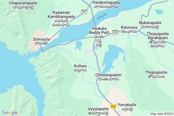
Rajupalem Map
EDIT Map
Add Your House
 ..
..
Current Corona Virus Infected Patients Count in Spsr Nellore District
| City Name | District Name | Total Covid cases |
|---|---|---|
| S.P.S. Nellore District | S.P.S. Nellore | 49 |
| Nellore | S.P.S. Nellore | 5 |
| Naidupeta | S.P.S. Nellore | 3 |
| Tada | S.P.S. Nellore | 2 |
| Kotamitta | S.P.S. Nellore | 2 |
| Vakadu | S.P.S. Nellore | 2 |
| Gudur | S.P.S. Nellore | 1 |
| Thirumuru | S.P.S. Nellore | 1 |
| Magunta Layout | S.P.S. Nellore | 1 |
| Turimella | S.P.S. Nellore | 1 |
| Nelamalipudi,Ozhili | S.P.S. Nellore | 1 |
| Chandrababu Nagar | S.P.S. Nellore | 1 |
| Tada Mandal | S.P.S. Nellore | 1 |
| Mallam | S.P.S. Nellore | 1 |
| Ranganayakakulapeta | S.P.S. Nellore | 1 |
| Haripriya Garden | S.P.S. Nellore | 1 |
| Pedda Bazar | S.P.S. Nellore | 1 |
Locality Name :
Rajupalem
( రాజుపాలెం )
Mandal Name : Kaluvoya
District : Spsr Nellore
State : Andhra Pradesh
Region : Andhra
Language : Telugu and Urdu
Current Time 02:04 PM
Date: Monday , Apr 28,2025 (IST)
Time zone: IST (UTC+5:30)
Elevation / Altitude: 154 meters. Above Seal level
Telephone Code / Std Code: 08628
Assembly constituency : assembly constituency
Assembly MLA : ANAM RAMANARAYANA REDDY
Lok Sabha constituency : parliamentary constituency
Parliament MP :
Serpanch Name :
Pin Code : 524343
Post Office Name : Kaluvoya
Main Village Name : Kulluru
Commodities Prices : Cuddapah Market / Mandi
Edit below overview about Rajupalem
Edit below overview about Rajupalem
OverView of Rajupalem
Majority of people living in this village are SuryaVamsa keshtriyas (Rajuâs) from load Rama family. Most of the young generation living in foreign countries like U.S.A, UK and AUS. The whole village surround by mountains, ponds, agriculture lands. One of the beautiful village.Edit below overview about Rajupalem
National Highways Reachable To Rajupalem
Nationa High Way :NH16;NH67
Nationa High Way :NH716
Nationa High Way :NH16;NH67
Nationa High Way :NH716
Rivers Near Rajupalem
Penna :Penna River :पेन्नार नदी :ಪೆನ್ನಾ :പെണ്ണാർ നദി :పెన్నా
Sagileru
Penna :Penna River :पेन्नार नदी :ಪೆನ್ನಾ :പെണ്ണാർ നദി :పెన్నా
Sagileru
About Rajupalem
Rajupalem is a small Village/hamlet in Kaluvoya Mandal in Spsr Nellore District of Andhra Pradesh State, India. It comes under Kulluru Panchayath. It belongs to Andhra region . It is located 77 KM towards west from District head quarters Nellore. 13 KM from Kaluvoya. 393 KM from State capital Hyderabad
Rajupalem Pin code is 524343 and postal head office is Kaluvoya .
Rajupalem is surrounded by Kaluvoya Mandal towards East , Marripadu Mandal towards North , Penagalur Mandal towards South , Chejerla Mandal towards East .
Kadapa , Cuddapah , Venkatagiri , Gudur are the near by Cities to Rajupalem.
Demographics of Rajupalem
Telugu is the Local Language here. Total population of Rajupalem is 5203 .Males are 2646 and Females are 2,557 living in 1332 Houses. Total area of Rajupalem is 3045 hectares.HOW TO REACH Rajupalem
By Road
Nellore is the Nearest Town to Rajupalem. Nellore is 74 km from Rajupalem. Road connectivity is there from Nellore to Rajupalem.By Rail
There is no railway station near to Rajupalem in less than 10 km. How ever there are railway Stations from Near By town Nellore. are the railway Stations near to Nellore. You can reach from Nellore to Rajupalem by road after .By Bus
Anathasagaram APSRTC Bus Station , Revuru APSRTC Bus Station , Marripadu APSRTC Bus Station are the nearby by Bus Stations to Rajupalem .APSRTC runs Number of busses from major cities to here.Colleges near Rajupalem
Govt Jr College Kulluru
Address : Govt Jr College Kulluru
Sri Siva Sai Degree College
Address : Main Road, S.no.794, D.no.9/182, Kaluvoya, Nellor
Schools in Rajupalem
Govt Hs Kulluru
Address : kulluru , kaluvoya , nellore , Andhra Pradesh . PIN- 524343 , Post - Kaluvoya
Govt Health Centers near Rajupalem
1) Sc Kammavaripalli , Apr-49 , MAIN ROAD , MAIN ROAD2) Pothapi , , pothapi , opp.govt high school
3) Kondur , 0 , Kondur , Near ZPH School
Petrol Bunks in Rajupalem,Kaluvoya
HP PETROL PUMP - SRI SATYASAI FILLING STATION
Hpcl Dealers Ananthasagaram Village; Ananthasagaram Mandal; Nellore; Andhra Pradesh 524302; India
13.0 KM distance Detail
Bharat Petroleum
Somasila-Atmakur Road; Somasila Rd; Andhra Pradesh 524302; India
14.0 KM distance Detail
more ..
Schools in Rajupalem,Kaluvoya
Baddevolu Elementary School
Baddevolu Road; Penna Baddevolu; Andhra Pradesh 524343; India
6.2 KM distance Detail
Super Markets in Rajupalem,Kaluvoya
About Rajupalem &
History
How to reach Rajupalem
Tourist Places Near By Rajupalem
Schools in Rajupalem
Colleges in Rajupalem
Temperature & weather of Rajupalem
places in Rajupalem
Rajupalem photos
More Information
How to reach Rajupalem
Tourist Places Near By Rajupalem
Schools in Rajupalem
Colleges in Rajupalem
Temperature & weather of Rajupalem
places in Rajupalem
Rajupalem photos
More Information
Village Talk
Post News or Events about this Village
Near Cities
Kadapa 63 KM near
Cuddapah 63 KM near
Venkatagiri 69 KM near
Gudur 73 KM near
Kadapa 63 KM near
Cuddapah 63 KM near
Venkatagiri 69 KM near
Gudur 73 KM near
Near By Taluks
Kaluvoya 12 KM near
Ananthasagaram 13 KM near
Marripadu 27 KM near
Penagalur 27 KM near
Kaluvoya 12 KM near
Ananthasagaram 13 KM near
Marripadu 27 KM near
Penagalur 27 KM near
Near By Air Ports
Tirupati Airport 107 KM near
Chennai Airport 210 KM near
Bengaluru International Airport 255 KM near
Vijayawada Airport 308 KM near
Tirupati Airport 107 KM near
Chennai Airport 210 KM near
Bengaluru International Airport 255 KM near
Vijayawada Airport 308 KM near
Near By Tourist Places
Kadapa 64 KM near
Nellore 73 KM near
Srikalahasti 99 KM near
Tirupati 106 KM near
Horsley Hills 155 KM near
Kadapa 64 KM near
Nellore 73 KM near
Srikalahasti 99 KM near
Tirupati 106 KM near
Horsley Hills 155 KM near
Near By Districts
Cuddapah 63 KM near
Spsr Nellore 73 KM near
Prakasam 151 KM near
Chittoor 161 KM near
Cuddapah 63 KM near
Spsr Nellore 73 KM near
Prakasam 151 KM near
Chittoor 161 KM near
Near By RailWay Station
Nandalur Rail Way Station 40 KM near
Razampeta Rail Way Station 44 KM near
Nandalur Rail Way Station 40 KM near
Razampeta Rail Way Station 44 KM near