| Home | City Bus | Maps | Villages | Cities | Rail | Tourist Places | School | College | Pin Codes | Corona Cases Count |
| Distance Calculator Bus Services IFSC Codes Trace Mobile Number Weather Search Place Trace IP Available Cash ATM/Banks Locate Polling Booth Report an Error contact People |
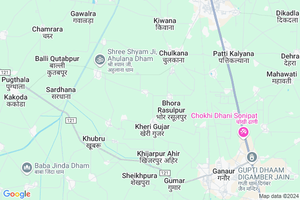
Atail Map
EDIT Map
Add Your House
 ..
..
Current Corona Virus Infected Patients Count in Sonipat District
| City Name | District Name | Total Covid cases |
|---|---|---|
| Sonipat District | Sonipat | 19 |
| Sonepat | Sonipat | 1 |
Locality Name :
Atail
( अटैल )
Tehsil Name : Ganaur
District : Sonipat
State : Haryana
Division : Rohtak
Language : Hindi and Punjabi,urdu
Current Time 12:51 PM
Date: Thursday , Apr 24,2025 (IST)
Time zone: IST (UTC+5:30)
Elevation / Altitude: 222 meters. Above Seal level
Telephone Code / Std Code: 0180
Assembly constituency : Ganaur assembly constituency
Assembly MLA : Nirmal Rani
Lok Sabha constituency : Sonipat parliamentary constituency
Parliament MP : RAMESH CHANDER KAUSHIK
Serpanch Name :
Pin Code : 131101
Post Office Name : Ganaur
Commodities Prices : Ganaur Market / Mandi
Atail Live Weather
Temperature: 38.0 °C
clear sky
Humidity: 5%
Wind : 2.72 mt/sec towards SW
StationName : "SamÄ\u0081lkha"
observed on 2 Hours Back
Temperature: 38.0 °C
clear sky
Humidity: 5%
Wind : 2.72 mt/sec towards SW
StationName : "SamÄ\u0081lkha"
observed on 2 Hours Back
Atail Weather Forecast for Next 5 days
25-04-2025
28.0°C to 41.6°C
clear sky
28.0°C to 41.6°C
clear sky
26-04-2025
26.9°C to 42.6°C
clear sky, few clouds, scattered clouds, broken clouds, overcast clouds
26.9°C to 42.6°C
clear sky, few clouds, scattered clouds, broken clouds, overcast clouds
27-04-2025
27.7°C to 40.9°C
broken clouds, overcast clouds
27.7°C to 40.9°C
broken clouds, overcast clouds
28-04-2025
27.0°C to 42.3°C
overcast clouds, scattered clouds, clear sky
27.0°C to 42.3°C
overcast clouds, scattered clouds, clear sky
29-04-2025
24.9°C to 41.5°C
clear sky, scattered clouds, broken clouds, overcast clouds
24.9°C to 41.5°C
clear sky, scattered clouds, broken clouds, overcast clouds
Edit below overview about Atail
Edit below overview about Atail
OverView of Atail
Atai is a such a nice place where are people loving each other. Atail is only pure jatt village.Edit below overview about Atail
National Highways Reachable To Atail
Nationa High Way :NH44
Nationa High Way :NH9
Nationa High Way :NH44
Nationa High Way :NH9
About Atail
Atail is a Village in Ganaur Tehsil in Sonipat District of Haryana State, India. It belongs to Rohtak Division . It is located 26 KM towards North from District head quarters Sonipat. 10 KM from Ganaur. 202 KM from State capital Chandigarh
Atail Pin code is 131101 and postal head office is Ganaur .
Kheri Gujjar ( 2 KM ) , Naya Bans ( 3 KM ) , Bulandpur ( 4 KM ) , Khubru ( 5 KM ) , Sardhana ( 6 KM ) are the nearby Villages to Atail. Atail is surrounded by Ganaur Tehsil towards South , Israna Tehsil towards North , Sonipat Tehsil towards South , Gohana Tehsil towards west .
Samalkha , Ganaur , Sonipat , Panipat are the near by Cities to Atail.
This Place is in the border of the Sonipat District and Panipat District. Panipat District Samalkha is East towards this place . Also it is in the Border of other district Baghpat . It is near to the Uttar Pradesh State Border.
Atail 2011 Census Details
Atail Local Language is Hindi. Atail Village Total population is 1468 and number of houses are 267. Female Population is 47.1%. Village literacy rate is 70.4% and the Female Literacy rate is 30.0%.
Population
| Census Parameter | Census Data |
| Total Population | 1468 |
| Total No of Houses | 267 |
| Female Population % | 47.1 % ( 691) |
| Total Literacy rate % | 70.4 % ( 1034) |
| Female Literacy rate | 30.0 % ( 441) |
| Scheduled Tribes Population % | 0.0 % ( 0) |
| Scheduled Caste Population % | 12.2 % ( 179) |
| Working Population % | 48.3 % |
| Child(0 -6) Population by 2011 | 170 |
| Girl Child(0 -6) Population % by 2011 | 42.4 % ( 72) |
Atail Census More Deatils.
Politics in Atail
Bharatiya Janata Party , BJP , INC , INLD are the major political parties in this area.Polling Stations /Booths near Atail
1)Govt. Middle School2)Govt. Middle School
3)Govt. Senior Secondry School South Wing
4)Govt. Senior Secondry School North Wing
5)Near The House Of Ramesh S/o Ratan Chaupal Of Schedule Caste
HOW TO REACH Atail
By Rail
Bhodwal Majri Rail Way Station , Samalkha Rail Way Station are the very nearby railway stations to Atail.Colleges near Atail
Puran Murti College Of Engineering In Kami (jagpal Singh)
Address :
Hindu College Sonipat
Address :
Bharat Nain S/o Jagpal Singh Nain
Address :
Jagpal Nain S/o Dharam Singh Nain
Address :
Schools in Atail
Gms
Address : atail , ganaur , sonipat , Haryana . PIN- 131101 , Post - Ganaur
Govt Health Centers near Atail
1) Ahulana , , ,2) Kheri Gujar , , ,
3) Naya Bans , , ,
Hospitals in Atail,Ganaur
Sehrawat hospital
Near fly over ; khubru road Ganaur; Gannaur; Haryana 131101; India
7.3 KM distance Detail
Dhankar Nursing Home
Gannaur Road; Vasant Vihar; Gannaur; Haryana 131101; India
7.5 KM distance Detail
more ..
Petrol Bunks in Atail,Ganaur
Baba Sankar Nath Filling Station Indian Oil Petrol Pump
Ganaur - Gohana Rd; Sonipat; Haryana 131101; India
6.8 KM distance Detail
Mahadevi Filling Station
Ganaur Rd; BST Colony; Gannaur; Haryana 131101; India
7.4 KM distance Detail
more ..
Colleges in Atail,Ganaur
TCM College of Enginering
G.T. Kamal Road; Charishmi; Tehsil Gannaur; National Highway 1; Sonepat; Haryana 131101; India
7.7 KM distance Detail
Innovative Institute of Technology & Management
Chirasmi; Gannaur;; National Highway 1; Sonepat; Haryana 131101; India
7.8 KM distance Detail
more ..
Schools in Atail,Ganaur
Govt. Sr. Sec. School; Kheri Gujjar [3470]
Kheri Gujar; Haryana 131101; India
1.7 KM distance Detail
Local Parks in Atail,Ganaur
Railway Park Ganaur
Market Committee Rd; Gandhi Nagar; Sonipat District; Gannaur; Haryana 131101; India
7.6 KM distance Detail
About Atail &
History
How to reach Atail
Tourist Places Near By Atail
Schools in Atail
Colleges in Atail
Temperature & weather of Atail
places in Atail
Atail photos
More Information
How to reach Atail
Tourist Places Near By Atail
Schools in Atail
Colleges in Atail
Temperature & weather of Atail
places in Atail
Atail photos
More Information
Village Talk
Post News or Events about this Village
Near Cities
Samalkha 7 KM near
Ganaur 8 KM near
Sonipat 25 KM near
Panipat 26 KM near
Samalkha 7 KM near
Ganaur 8 KM near
Sonipat 25 KM near
Panipat 26 KM near
Near By Taluks
Samalkha 8 KM near
Ganaur 9 KM near
Israna 17 KM near
Sonipat 23 KM near
Samalkha 8 KM near
Ganaur 9 KM near
Israna 17 KM near
Sonipat 23 KM near
Near By Air Ports
Indira Gandhi International Airport 78 KM near
Muzaffarnagar Airport 81 KM near
Dehra Dun Airport 182 KM near
Chandigarh Airport 187 KM near
Indira Gandhi International Airport 78 KM near
Muzaffarnagar Airport 81 KM near
Dehra Dun Airport 182 KM near
Chandigarh Airport 187 KM near
Near By Tourist Places
panipat 25 KM near
Karna lake 70 KM near
Delhi 73 KM near
Meerut 82 KM near
Noida 85 KM near
panipat 25 KM near
Karna lake 70 KM near
Delhi 73 KM near
Meerut 82 KM near
Noida 85 KM near
Near By Districts
Sonipat 24 KM near
Panipat 25 KM near
Baghpat 40 KM near
North West Delhi 51 KM near
Sonipat 24 KM near
Panipat 25 KM near
Baghpat 40 KM near
North West Delhi 51 KM near
Near By RailWay Station
Bhodwal Majri Rail Way Station 4.4 KM near
Ganaur Rail Way Station 7.8 KM near
Samalkha Rail Way Station 8.9 KM near
Bhodwal Majri Rail Way Station 4.4 KM near
Ganaur Rail Way Station 7.8 KM near
Samalkha Rail Way Station 8.9 KM near