| Home | City Bus | Maps | Villages | Cities | Rail | Tourist Places | School | College | Pin Codes | Corona Cases Count |
| Distance Calculator Bus Services IFSC Codes Trace Mobile Number Weather Search Place Trace IP Available Cash ATM/Banks Locate Polling Booth Report an Error contact People |
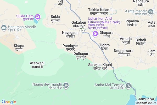
Dulhapur
Dulhapur Map
EDIT Map
Add Your House
 ..
..
Current Corona Virus Infected Patients Count in Seoni District
| City Name | District Name | Total Covid cases |
|---|
Locality Name :
Dulhapur
( दुल्हापुर )
Tehsil Name : Barghat
District : Seoni
State : Madhya Pradesh
Division : Jabalpur
Language : Hindi
Current Time 05:27 PM
Date: Tuesday , Apr 29,2025 (IST)
Time zone: IST (UTC+5:30)
Elevation / Altitude: 529 meters. Above Seal level
Telephone Code / Std Code: 07692
Assembly constituency : Barghat assembly constituency
Assembly MLA : Kamal Marskole
Lok Sabha constituency : Balaghat parliamentary constituency
Parliament MP : DR DHAL SINGH BISEN
Serpanch Name :
Pin Code : 480661
Post Office Name : Seoni
Commodities Prices : Khairlangi Market / Mandi
Rivers Near Dulhapur
Chadan
Ghisri
Chadan
Ghisri
About Dulhapur
Correct below Info and add more info about DulhapurDulhapur is a Village in Barghat Tehsil in Seoni District of Madhya Pradesh State, India. It belongs to Jabalpur Division . It is located 33 KM towards South from District head quarters Seoni. 16 KM from Barghat. 330 KM from State capital Bhopal
Dulhapur Pin code is 480661 and postal head office is Seoni .
Tighra ( 3 KM ) , Sarekhakhurd ( 3 KM ) , Gokalpur ( 3 KM ) , Dhapara(gangrua) ( 3 KM ) , Dhapara ( 5 KM ) are the nearby Villages to Dulhapur. Dulhapur is surrounded by Katangi Tehsil towards South , Kurai Tehsil towards west , Seoni Tehsil towards North , Lalbarra Tehsil towards East .
Seoni , Wara Seoni , Balaghat , Tumsar are the near by Cities to Dulhapur.
Dulhapur 2011 Census Details
Dulhapur Local Language is Hindi. Dulhapur Village Total population is 1539 and number of houses are 397. Female Population is 51.2%. Village literacy rate is 71.5% and the Female Literacy rate is 33.1%.
Population
| Census Parameter | Census Data |
| Total Population | 1539 |
| Total No of Houses | 397 |
| Female Population % | 51.2 % ( 788) |
| Total Literacy rate % | 71.5 % ( 1101) |
| Female Literacy rate | 33.1 % ( 510) |
| Scheduled Tribes Population % | 22.7 % ( 349) |
| Scheduled Caste Population % | 5.8 % ( 90) |
| Working Population % | 53.6 % |
| Child(0 -6) Population by 2011 | 183 |
| Girl Child(0 -6) Population % by 2011 | 49.2 % ( 90) |
Dulhapur Census More Deatils.
Politics in Dulhapur
Bharatiya Janata Party , BJP , INC are the major political parties in this area.Polling Stations /Booths near Dulhapur
1)Doudiwara2)Mohgaon
3)Thavarjhodi
4)Dhapara
5)Sarekhakala
HOW TO REACH Dulhapur
By Rail
There is no railway station near to Dulhapur in less than 10 km.Colleges near Dulhapur
Govt. Art And Commerce College , Keolari
Address :
Universal Institute Of Computer Technology
Address : Bineki Road Keolari
Aman Institute Of Computer Technology
Address : Palari
Gwlior Institute Of Technology And Science
Address : Kedarpur, Shivpuri Link Road, Lashkar, Gwalior
Schools in Dulhapur
Gps Heti Tola(dulhapur)
Address : dulhapur , barghat , seoni , Madhya Pradesh . PIN- 480661 , Post - Seoni
Uegs Bapu Tola
Address : dulhapur , barghat , seoni , Madhya Pradesh . PIN- 480661 , Post - Seoni
Gps Dulhapur
Address : dulhapur , barghat , seoni , Madhya Pradesh . PIN- 480661 , Post - Seoni
Govt Health Centers near Dulhapur
1) PHC Dhapara , PHC DHAPARA , GRAMPANCHAT DHAPARA , BAJAR CHOK DHAPARA2) PHC Behrai , PHC BEHRAI , GRAMPANCHAT BEHRAI , BAGAR CHOK BEHRAI
3) SHC Gokalpur , SHC GOKALPUR , GRAM PANCHAT GOKALPUR ,
Hospitals in Dulhapur,Barghat
indira gandhi hospitol barghat
MP SH 26; Barghat; Madhya Pradesh 480667; India
18.1 KM distance Detail
more ..
Petrol Bunks in Dulhapur,Barghat
HP PETROL PUMP - ADHOC RAM PETROLEUM
HPC Dealer Vill-khunt; Tehsil-barghat Balaghat Road; Jabalpur; Madhya Pradesh 480667; India
18.7 KM distance Detail
more ..
Colleges in Dulhapur,Barghat
AIMS College of Paramedical & Science;Barghat
MP SH 26; Barghat; Madhya Pradesh 480667; India
18.4 KM distance Detail
more ..
Schools in Dulhapur,Barghat
SHRI NARBADA PLAY SCHOOL
DHHAPARA ROAD; GANGERUA;; Seoni; Madhya Pradesh 480661; India
2.9 KM distance Detail
Government Higher Secondary School Gangerua
Dhapara; Madhya Pradesh 480771; India
2.9 KM distance Detail
CAREER POINT COACHING GANGERUA
gangerua; Dhapara; Madhya Pradesh 480771; India
3.0 KM distance Detail
Government Higher Secondary School; Gangerua
Gangerua Road; Dhapara; Madhya Pradesh 480771; India
3.2 KM distance Detail
Bhoj University; Examination Centre
Gangerua Road; Dhapara; Madhya Pradesh 480771; India
3.3 KM distance Detail
Super Markets in Dulhapur,Barghat
temhre auto and computer center
Katangi Rd; Mohgaon; Madhya Pradesh 480771; India
2.9 KM distance Detail
Local Parks in Dulhapur,Barghat
Gandhi Baag Barghat
20; Madhya Pradesh State Highway 26; Barghat; Madhya Pradesh 480667; India
18.9 KM distance Detail
Governement Offices near Dulhapur,Barghat
Krishi Upaj Mandi Barghat
20; Madhya Pradesh State Highway 26; Madhya Pradesh 480667; India
18.4 KM distance Detail
About Dulhapur &
History
How to reach Dulhapur
Tourist Places Near By Dulhapur
Schools in Dulhapur
Colleges in Dulhapur
Temperature & weather of Dulhapur
places in Dulhapur
Dulhapur photos
More Information
How to reach Dulhapur
Tourist Places Near By Dulhapur
Schools in Dulhapur
Colleges in Dulhapur
Temperature & weather of Dulhapur
places in Dulhapur
Dulhapur photos
More Information
Village Talk
Post News or Events about this Village
Near Cities
Seoni 30 KM near
Wara Seoni 41 KM near
Balaghat 55 KM near
Tumsar 62 KM near
Seoni 30 KM near
Wara Seoni 41 KM near
Balaghat 55 KM near
Tumsar 62 KM near
Near By Taluks
Barghat 15 KM near
Katangi 21 KM near
Kurai 25 KM near
Seoni 37 KM near
Barghat 15 KM near
Katangi 21 KM near
Kurai 25 KM near
Seoni 37 KM near
Near By Air Ports
Jabalpur Airport 99 KM near
Sonegaon Airport 125 KM near
Raipur Airport 249 KM near
Bhopal Airport 323 KM near
Jabalpur Airport 99 KM near
Sonegaon Airport 125 KM near
Raipur Airport 249 KM near
Bhopal Airport 323 KM near
Near By Tourist Places
Pench National Park 11 KM near
Seoni 31 KM near
Bhandara 90 KM near
Kanha National park 114 KM near
Nagpur 117 KM near
Pench National Park 11 KM near
Seoni 31 KM near
Bhandara 90 KM near
Kanha National park 114 KM near
Nagpur 117 KM near
Near By Districts
Seoni 31 KM near
Balaghat 54 KM near
Gondia 77 KM near
Bhandara 89 KM near
Seoni 31 KM near
Balaghat 54 KM near
Gondia 77 KM near
Bhandara 89 KM near
Near By RailWay Station
Tirora Rail Way Station 63 KM near
Tumsar Road Junction Rail Way Station 68 KM near
Tirora Rail Way Station 63 KM near
Tumsar Road Junction Rail Way Station 68 KM near