| Home | City Bus | Maps | Villages | Cities | Rail | Tourist Places | School | College | Pin Codes | Corona Cases Count |
| Distance Calculator Bus Services IFSC Codes Trace Mobile Number Weather Search Place Trace IP Available Cash ATM/Banks Locate Polling Booth Report an Error contact People |
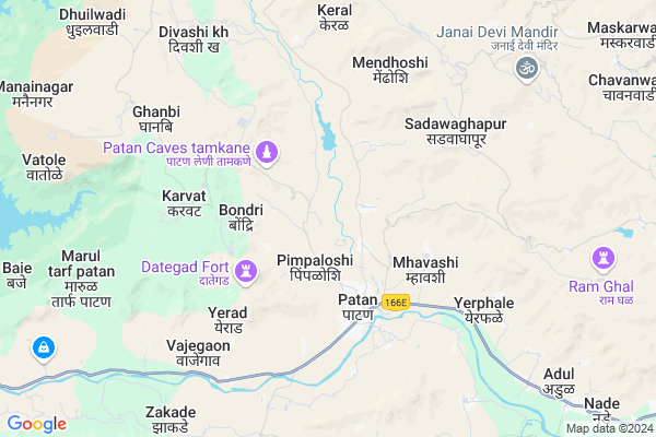
Ker
Ker Map
EDIT Map
Add Your House
 ..
..
Current Corona Virus Infected Patients Count in Satara District
| City Name | District Name | Total Covid cases |
|---|---|---|
| Satara District | Satara | 16 |
| Khandala | Satara | 1 |
Locality Name :
Ker
( केर )
Taluka Name : Patan
District : Satara
State : Maharashtra
Region : Desh or Paschim Maharashtra
Division : Pune
Language : Marathi and Satara
Current Time 11:18 AM
Date: Sunday , Apr 27,2025 (IST)
Time zone: IST (UTC+5:30)
Elevation / Altitude: 610 meters. Above Seal level
Telephone Code / Std Code: 02372
Assembly constituency : Patan assembly constituency
Assembly MLA : Desai Shambhuraj Shivajirao
Lok Sabha constituency : Satara parliamentary constituency
Parliament MP : SHRIMANT CHH. UDAYANRAJE PRATAPSINHMAHARAJ BHONSLE
Serpanch Name :
Pin Code : 415206
Post Office Name : Patan (Satara)
Commodities Prices : Patan Market / Mandi
Ker Live Weather
Temperature: 37.5 °C
few clouds
Humidity: 18%
Wind : 1.66 mt/sec towards NE
StationName : "PÄ\u0081tan"
observed on Now
Temperature: 37.5 °C
few clouds
Humidity: 18%
Wind : 1.66 mt/sec towards NE
StationName : "PÄ\u0081tan"
observed on Now
Ker Weather Forecast for Next 5 days
28-04-2025
20.6°C to 37.5°C
few clouds, scattered clouds, clear sky
20.6°C to 37.5°C
few clouds, scattered clouds, clear sky
29-04-2025
20.9°C to 39.0°C
scattered clouds, overcast clouds, broken clouds, few clouds
20.9°C to 39.0°C
scattered clouds, overcast clouds, broken clouds, few clouds
30-04-2025
20.0°C to 38.9°C
few clouds, scattered clouds, clear sky
20.0°C to 38.9°C
few clouds, scattered clouds, clear sky
01-05-2025
19.9°C to 37.3°C
scattered clouds, few clouds, clear sky
19.9°C to 37.3°C
scattered clouds, few clouds, clear sky
02-05-2025
20.7°C to 38.7°C
clear sky, scattered clouds
20.7°C to 38.7°C
clear sky, scattered clouds
National Highways Reachable To Ker
Nationa High Way :NH166E
Nationa High Way :NH48
Nationa High Way :NH166E
Nationa High Way :NH48
Rivers Near Ker
Tulsi
Tulsi
About Ker
Correct below Info and add more info about KerKer is a Village in Patan Taluka in Satara District of Maharashtra State, India. It belongs to Desh or Paschim Maharashtra region . It belongs to Pune Division . It is located 39 KM towards South from District head quarters Satara. 8 KM from Patan. 245 KM from State capital Mumbai
Ker Pin code is 415206 and postal head office is Patan (Satara).
Pimpaloshi ( 2 KM ) , Ambavane ( 2 KM ) , Bondri ( 2 KM ) , Katwadi ( 2 KM ) , Chiteghar ( 2 KM ) are the nearby Villages to Ker. Ker is surrounded by Karad Taluka towards East , Satara Taluka towards North , Chipalun Taluka towards west , Sangmeshwar Taluka towards west .
Karad , Satara , Chiplun , Uran Islampur are the near by Cities to Ker.
Ker 2011 Census Details
Ker Local Language is Marathi. Ker Village Total population is 727 and number of houses are 144. Female Population is 51.2%. Village literacy rate is 63.3% and the Female Literacy rate is 26.4%.
Population
| Census Parameter | Census Data |
| Total Population | 727 |
| Total No of Houses | 144 |
| Female Population % | 51.2 % ( 372) |
| Total Literacy rate % | 63.3 % ( 460) |
| Female Literacy rate | 26.4 % ( 192) |
| Scheduled Tribes Population % | 0.0 % ( 0) |
| Scheduled Caste Population % | 18.2 % ( 132) |
| Working Population % | 55.4 % |
| Child(0 -6) Population by 2011 | 78 |
| Girl Child(0 -6) Population % by 2011 | 48.7 % ( 38) |
Ker Census More Deatils.
Politics in Ker
Nationalist Congress Party , NCP , SHS are the major political parties in this area.Polling Stations /Booths near Ker
1)Samajmandir Vasti Sakurdi2)Z.p.primary School Room No.1 Awarde
3)Z.p.primary School Room No.1 Humbarne
4)Z.p.primary School Room No 1 Shindewadi
5)Grampanchayat Karyalaya Gokul Tarf Helwak
HOW TO REACH Ker
By Road
Karad is the Nearest Town to Ker. Karad is 39 km from Ker. Road connectivity is there from Karad to Ker.By Rail
There is no railway station near to Ker in less than 10 km. How ever there are railway Stations from Near By town Karad. are the railway Stations near to Karad. You can reach from Karad to Ker by road after .Colleges near Ker
Zhilha Parishad Prathmic Shala,vekhandwadi
Address :
Shri Naikaba Vidyalaya, Galmewadi
Address :
Balasaheb Desai College Patan
Address :
Schools in Ker
Z.p.ps Ker
Address : ker , patan , satara , Maharashtra . PIN- 415206 , Post - Patan (Satara)
Govt Health Centers near Ker
1) Mhavashi , , ,2) Mendhoshi , , ,
3) Keral , 140 , keral rod , keral village
Hospitals in Ker,Patan
Patan Gramin Rugnalaya (Patan Cottage Hospital)
Patan; Maharashtra 415206; India
2.9 KM distance Detail
more ..
Colleges in Ker,Patan
Balasaheb Desai College; Patan
Balasaheb Desai College Rd; Patan; Maharashtra 415206; India
2.7 KM distance Detail
Modarn Computer Institute Patan
Zenda Chowk; Kumbharwada; Patan; Maharashtra 415206; India
3.9 KM distance Detail
more ..
Schools in Ker,Patan
Mane Deshmukh Vidyalay ; Patan
near mahalaxmi temple;; Surul Road; Patan; India
2.9 KM distance Detail
Electronic Shops in Ker,Patan
Hind Electronics And Mobiles
Somwar Peth Main Raod;; Tal-Patan; Dist-Satara;; Patan; Maharashtra 415206; India
3.6 KM distance Detail
Local Parks in Ker,Patan
reves water fall lugadewadi
Patan - Mandure Road; Surul; Maharashtra 415206; India
2.0 KM distance Detail
Governement Offices near Ker,Patan
Tahasil Office Patan
Surul Road; Brahmanpuri; Patan; Maharashtra 415206; India
3.0 KM distance Detail
About Ker &
History
How to reach Ker
Tourist Places Near By Ker
Schools in Ker
Colleges in Ker
Temperature & weather of Ker
places in Ker
Ker photos
More Information
How to reach Ker
Tourist Places Near By Ker
Schools in Ker
Colleges in Ker
Temperature & weather of Ker
places in Ker
Ker photos
More Information
Village Talk
Post News or Events about this Village
Near Cities
Karad 28 KM near
Satara 39 KM near
Chiplun 46 KM near
Uran Islampur 62 KM near
Karad 28 KM near
Satara 39 KM near
Chiplun 46 KM near
Uran Islampur 62 KM near
Near By Taluks
Patan 7 KM near
Karad 31 KM near
Satara 35 KM near
Chipalun 46 KM near
Patan 7 KM near
Karad 31 KM near
Satara 35 KM near
Chipalun 46 KM near
Near By Air Ports
Kolhapur Airport 105 KM near
Lohegaon Airport 147 KM near
Sambre Airport 210 KM near
Chhatrapati Shivaji International Airport 242 KM near
Kolhapur Airport 105 KM near
Lohegaon Airport 147 KM near
Sambre Airport 210 KM near
Chhatrapati Shivaji International Airport 242 KM near
Near By Tourist Places
Mandwa 21 KM near
Satara 39 KM near
Panchgani 65 KM near
Mahabaleshwar 70 KM near
Panhala 77 KM near
Mandwa 21 KM near
Satara 39 KM near
Panchgani 65 KM near
Mahabaleshwar 70 KM near
Panhala 77 KM near
Near By Districts
Satara 38 KM near
Ratnagiri 87 KM near
Kolhapur 96 KM near
Sangli 106 KM near
Satara 38 KM near
Ratnagiri 87 KM near
Kolhapur 96 KM near
Sangli 106 KM near
Near By RailWay Station
Karad Rail Way Station 40 KM near
Satara Rail Way Station 41 KM near
Karad Rail Way Station 40 KM near
Satara Rail Way Station 41 KM near