| Home | City Bus | Maps | Villages | Cities | Rail | Tourist Places | School | College | Pin Codes | Corona Cases Count |
| Distance Calculator Bus Services IFSC Codes Trace Mobile Number Weather Search Place Trace IP Available Cash ATM/Banks Locate Polling Booth Report an Error contact People |
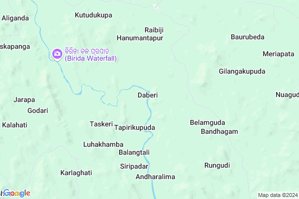
Daberi
Daberi Map
EDIT Map
Add Your House
 ..
..
Current Corona Virus Infected Patients Count in Rayagada District
| City Name | District Name | Total Covid cases |
|---|
Locality Name :
Daberi
( ଦାବେରି )
Tehsil Name : Chandrapur
District : Rayagada
State : Odisha
Language : Oriya and Hindi, Telugu
Current Time 09:45 AM
Date: Thursday , Apr 24,2025 (IST)
Time zone: IST (UTC+5:30)
Elevation / Altitude: 335 meters. Above Seal level
Telephone Code / Std Code: 06862
Assembly constituency : Gunupur assembly constituency
Assembly MLA : trinath gomango
Lok Sabha constituency : Koraput parliamentary constituency
Parliament MP : SAPTAGIRI SANKAR ULAKA
Serpanch Name :
Commodities Prices : Rayagada(Muniguda) Market / Mandi
Rivers Near Daberi
Nagavali
Vamsadhara
Nagavali
Vamsadhara
About Daberi
Correct below Info and add more info about DaberiDaberi is a small Village/hamlet in Chandrapur Tehsil in Rayagada District of Odisha State, India. It is located 61 KM towards North from District head quarters Rayagada. 6 KM from Chandrapur. 274 KM from State capital Bhubaneswar
Piskapanga ( 12 KM ) , Dangasorada ( 15 KM ) , Siriguda ( 16 KM ) are the nearby Villages to Daberi. Daberi is surrounded by Gudari Tehsil towards South , Bissamcuttack Tehsil towards west , Muniguda Tehsil towards west , Padmapur Tehsil towards South .
Gunupur , Rayagada , Bhawanipatna , Parvathipuram are the near by Cities to Daberi.
Daberi 2011 Census Details
Daberi Local Language is Oriya. Daberi Village Total population is 313 and number of houses are 65. Female Population is 53.7%. Village literacy rate is 11.8% and the Female Literacy rate is 2.2%.
Population
| Census Parameter | Census Data |
| Total Population | 313 |
| Total No of Houses | 65 |
| Female Population % | 53.7 % ( 168) |
| Total Literacy rate % | 11.8 % ( 37) |
| Female Literacy rate | 2.2 % ( 7) |
| Scheduled Tribes Population % | 98.1 % ( 307) |
| Scheduled Caste Population % | 0.0 % ( 0) |
| Working Population % | 29.7 % |
| Child(0 -6) Population by 2011 | 88 |
| Girl Child(0 -6) Population % by 2011 | 55.7 % ( 49) |
Daberi Census More Deatils.
Politics in Daberi
BJP , BJD , INC are the major political parties in this area.Polling Stations /Booths near Daberi
1)Upper Primary School Pradhaniguda2)Primary School Gumuda Laxmipur
3)U.g.m.e. School(college Road) Upper Block Colony Gudari
4)Sevashram Bharsing
5)Primary School Kothapeta
HOW TO REACH Daberi
By Rail
There is no railway station near to Daberi in less than 10 km.Pincodes near Daberi
765020 ( Muniguda ) , 765026 ( Gudari ) , 765019 ( Bissamcuttack )Colleges near Daberi
Ma College Arts Kashipur
Address :
Centre For World Education Service
Address : Centre For World Education Service , Raniguda Far
Draupadi Junior College
Address : Gumuda
Institute Of Advanced Computer & Research
Address : Prajukti Vihar, Aurobindo Marg, Rayagada - 765 00
Majhighariani Institute Of Technology & Science
Address : Rayagada - 765017
Schools near Daberi
Govt Health Centers near Daberi
1) SC-Akhusingi , , ,2) SC-Judo , Judo, Sub-Center , Sahada Sector , Judo
3) SC-Seriguma , Seriguma SC , , Near GPO Office
Schools in Daberi,Chandrapur
Odisha Adarsha Vidyalaya (OAV); Gudari; Rayagada
Bamuni Dangar; Odisha 765026; India
22.3 KM distance Detail
Local Parks in Daberi,Chandrapur
Police Stations near Daberi,Chandrapur
Governement Offices near Daberi,Chandrapur
Tahasil Office; Gudari
19°21'01. 83°47'24.; 3; 4th Rd; Ram Krishna Nagar; Khar West; Mumbai; Maharashtra; India
22.9 KM distance Detail
About Daberi &
History
How to reach Daberi
Tourist Places Near By Daberi
Schools in Daberi
Colleges in Daberi
Temperature & weather of Daberi
places in Daberi
Daberi photos
More Information
How to reach Daberi
Tourist Places Near By Daberi
Schools in Daberi
Colleges in Daberi
Temperature & weather of Daberi
places in Daberi
Daberi photos
More Information
Village Talk
Post News or Events about this Village
Near Cities
Gunupur 54 KM near
Rayagada 58 KM near
Bhawanipatna 83 KM near
Parvathipuram 98 KM near
Gunupur 54 KM near
Rayagada 58 KM near
Bhawanipatna 83 KM near
Parvathipuram 98 KM near
Near By Taluks
Chandrapur 6 KM near
Gudari 20 KM near
Bissamcuttack 23 KM near
Muniguda 34 KM near
Chandrapur 6 KM near
Gudari 20 KM near
Bissamcuttack 23 KM near
Muniguda 34 KM near
Near By Air Ports
Vishakhapatnam Airport 231 KM near
Bhubaneswar Airport 259 KM near
Raipur Airport 312 KM near
Rajahmundry Airport 376 KM near
Vishakhapatnam Airport 231 KM near
Bhubaneswar Airport 259 KM near
Raipur Airport 312 KM near
Rajahmundry Airport 376 KM near
Near By Tourist Places
Kalahandi 79 KM near
Berhampur 126 KM near
Phulbani 132 KM near
Gopalpur 140 KM near
Jeypore 160 KM near
Kalahandi 79 KM near
Berhampur 126 KM near
Phulbani 132 KM near
Gopalpur 140 KM near
Jeypore 160 KM near
Near By Districts
Rayagada 58 KM near
Gajapati 59 KM near
Kalahandi 83 KM near
Kandhamal 132 KM near
Rayagada 58 KM near
Gajapati 59 KM near
Kalahandi 83 KM near
Kandhamal 132 KM near
Near By RailWay Station
Muniguda Rail Way Station 32 KM near
Therubali Rail Way Station 44 KM near
Muniguda Rail Way Station 32 KM near
Therubali Rail Way Station 44 KM near