| Home | City Bus | Maps | Villages | Cities | Rail | Tourist Places | School | College | Pin Codes | Corona Cases Count |
| Distance Calculator Bus Services IFSC Codes Trace Mobile Number Weather Search Place Trace IP Available Cash ATM/Banks Locate Polling Booth Report an Error contact People |
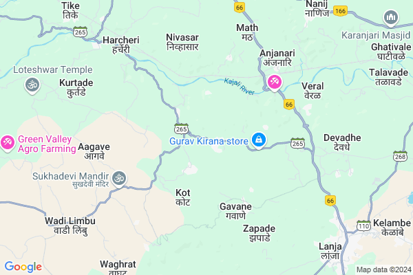
Punas
Punas Map
EDIT Map
Add Your House
 ..
..
Current Corona Virus Infected Patients Count in Ratnagiri District
| City Name | District Name | Total Covid cases |
|---|---|---|
| Ratnagiri District | Ratnagiri | 7 |
| Shrungartali | Ratnagiri | 1 |
Locality Name :
Punas
( पूनम )
Taluka Name : Lanja
District : Ratnagiri
State : Maharashtra
Region : Konkan
Division : Konkan
Language : Marathi and Daldi
Current Time 05:57 AM
Date: Saturday , Apr 26,2025 (IST)
Time zone: IST (UTC+5:30)
Elevation / Altitude: 72 meters. Above Seal level
Telephone Code / Std Code: 02351
Assembly constituency : Rajapur assembly constituency
Assembly MLA : Avinash Shantaram Lad
Lok Sabha constituency : Ratnagiri-Sindhudurg parliamentary constituency
Parliament MP : Vinayak Raut
Serpanch Name :
Pin Code : 416712
Post Office Name : Devadhe
Commodities Prices : Ratnagiri (Nachane) Market / Mandi
Punas Live Weather
Temperature: 22.9 °C
few clouds
Humidity: 82%
Wind : 1.83 mt/sec towards N
StationName : "LÄ\u0081nja"
observed on 2 Hours Back
Temperature: 22.9 °C
few clouds
Humidity: 82%
Wind : 1.83 mt/sec towards N
StationName : "LÄ\u0081nja"
observed on 2 Hours Back
Punas Weather Forecast for Next 5 days
27-04-2025
22.1°C to 36.9°C
clear sky, few clouds
22.1°C to 36.9°C
clear sky, few clouds
28-04-2025
22.4°C to 35.6°C
scattered clouds, broken clouds, clear sky
22.4°C to 35.6°C
scattered clouds, broken clouds, clear sky
29-04-2025
22.3°C to 35.9°C
scattered clouds, broken clouds, clear sky
22.3°C to 35.9°C
scattered clouds, broken clouds, clear sky
30-04-2025
21.8°C to 34.8°C
clear sky, few clouds
21.8°C to 34.8°C
clear sky, few clouds
National Highways Reachable To Punas
Nationa High Way :NH66
Nationa High Way :NH66;NH166
Nationa High Way :NH66
Nationa High Way :NH66;NH166
Rivers Near Punas
Warna River
Kumbhi
Warna River
Kumbhi
About Punas
Correct below Info and add more info about PunasPunas is a Village in Lanja Taluka in Ratnagiri District of Maharashtra State, India. It belongs to Konkan region . It belongs to Konkan Division . It is located 25 KM towards East from District head quarters Ratnagiri. 11 KM from Lanja. 285 KM from State capital Mumbai
Punas Pin code is 416712 and postal head office is Devadhe .
Nivsar ( 4 KM ) , Kot ( 4 KM ) , Anjanari ( 6 KM ) , Veral ( 6 KM ) , Math ( 6 KM ) are the nearby Villages to Punas. Punas is surrounded by Ratnagiri Taluka towards west , Rajapur Taluka towards South , Sangmeshwar Taluka towards North , Shahuwadi Taluka towards East .
Ratnagiri , Devgarh , Chiplun , Kolhapur are the near by Cities to Punas.
It is near to arabian sea. There is a chance of humidity in the weather.
Punas 2011 Census Details
Punas Local Language is Marathi. Punas Village Total population is 1334 and number of houses are 320. Female Population is 52.6%. Village literacy rate is 69.9% and the Female Literacy rate is 32.1%.
Population
| Census Parameter | Census Data |
| Total Population | 1334 |
| Total No of Houses | 320 |
| Female Population % | 52.6 % ( 702) |
| Total Literacy rate % | 69.9 % ( 932) |
| Female Literacy rate | 32.1 % ( 428) |
| Scheduled Tribes Population % | 0.0 % ( 0) |
| Scheduled Caste Population % | 0.2 % ( 3) |
| Working Population % | 34.7 % |
| Child(0 -6) Population by 2011 | 126 |
| Girl Child(0 -6) Population % by 2011 | 48.4 % ( 61) |
Punas Census More Deatils.
Politics in Punas
INC , SHS are the major political parties in this area.Polling Stations /Booths near Punas
1)Gavane2)Gavane
3)Punas
4)Chafavali
5)Kurchumb
HOW TO REACH Punas
By Rail
Nivasar Rail Way Station is the very nearby railway stations to Punas. Ratnagiri Rail Way Station (near to Ratnagiri) are the Rail way stations reachable from near by towns.By Road
Rajapur , Ratnagiri are the nearby by towns to Punas having road connectivity to PunasColleges near Punas
Saraswati Madhamic & Uchha Madhamic Vidya Mandir Ringane
Address :
Br. Nath Pai Jr. College Of Science
Address :
Schools in Punas
New English Sch. Punas
Address : punas , lanja , ratnagiri , Maharashtra . PIN- 416712 , Post - Devadhe
Zpps K.s. Punaskadu
Address : punas , lanja , ratnagiri , Maharashtra . PIN- 416712 , Post - Devadhe
Govt Health Centers near Punas
1) Punas , At Punas , Punas , Primary School2) Gawane , At Gawane , Karmbele Wadi , Near Grampanchayat
3) Koladhe , 340 , Kumbhargaon , Primary School
Schools in Punas,Lanja
Electronic Shops in Punas,Lanja
Super Markets in Punas,Lanja
Local Parks in Punas,Lanja
Police Stations near Punas,Lanja
Governement Offices near Punas,Lanja
About Punas &
History
How to reach Punas
Tourist Places Near By Punas
Schools in Punas
Colleges in Punas
Temperature & weather of Punas
places in Punas
Punas photos
More Information
How to reach Punas
Tourist Places Near By Punas
Schools in Punas
Colleges in Punas
Temperature & weather of Punas
places in Punas
Punas photos
More Information
Village Talk
Post News or Events about this Village
Near Cities
Ratnagiri 24 KM near
Devgarh 67 KM near
Chiplun 77 KM near
Kolhapur 91 KM near
Ratnagiri 24 KM near
Devgarh 67 KM near
Chiplun 77 KM near
Kolhapur 91 KM near
Near By Taluks
Lanja 11 KM near
Ratnagiri 19 KM near
Rajapur 31 KM near
Sangmeshwar 33 KM near
Lanja 11 KM near
Ratnagiri 19 KM near
Rajapur 31 KM near
Sangmeshwar 33 KM near
Near By Air Ports
Kolhapur Airport 106 KM near
Sambre Airport 188 KM near
Dabolim Airport 194 KM near
Lohegaon Airport 214 KM near
Kolhapur Airport 106 KM near
Sambre Airport 188 KM near
Dabolim Airport 194 KM near
Lohegaon Airport 214 KM near
Near By Tourist Places
Ratnagiri 24 KM near
Vijaydurg 47 KM near
Velneshwar 66 KM near
Kunkeshwar 72 KM near
Panhala 77 KM near
Ratnagiri 24 KM near
Vijaydurg 47 KM near
Velneshwar 66 KM near
Kunkeshwar 72 KM near
Panhala 77 KM near
Near By Districts
Ratnagiri 24 KM near
Kolhapur 94 KM near
Sindhudurg 102 KM near
Satara 114 KM near
Ratnagiri 24 KM near
Kolhapur 94 KM near
Sindhudurg 102 KM near
Satara 114 KM near
Near By RailWay Station
Nivasar Rail Way Station 5.7 KM near
Adavali Rail Way Station 13 KM near
Ratnagiri Rail Way Station 18 KM near
Nivasar Rail Way Station 5.7 KM near
Adavali Rail Way Station 13 KM near
Ratnagiri Rail Way Station 18 KM near