| Home | City Bus | Maps | Villages | Cities | Rail | Tourist Places | School | College | Pin Codes | Corona Cases Count |
| Distance Calculator Bus Services IFSC Codes Trace Mobile Number Weather Search Place Trace IP Available Cash ATM/Banks Locate Polling Booth Report an Error contact People |
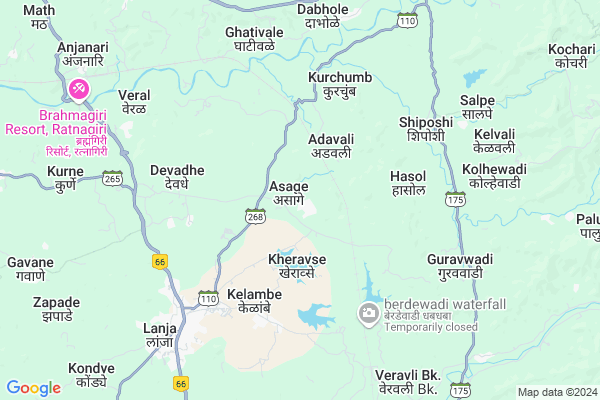
Asage
Asage Map
EDIT Map
Add Your House
 ..
..
Current Corona Virus Infected Patients Count in Ratnagiri District
| City Name | District Name | Total Covid cases |
|---|---|---|
| Ratnagiri District | Ratnagiri | 7 |
| Shrungartali | Ratnagiri | 1 |
Locality Name :
Asage
( असगे )
Taluka Name : Lanja
District : Ratnagiri
State : Maharashtra
Region : Konkan
Division : Konkan
Language : Marathi and Daldi
Current Time 07:14 PM
Date: Tuesday , Apr 29,2025 (IST)
Time zone: IST (UTC+5:30)
Elevation / Altitude: 72 meters. Above Seal level
Telephone Code / Std Code: 02351
Assembly constituency : Rajapur assembly constituency
Assembly MLA : Avinash Shantaram Lad
Lok Sabha constituency : Ratnagiri-Sindhudurg parliamentary constituency
Parliament MP : Vinayak Raut
Serpanch Name :
Pin Code : 416712
Post Office Name : Devadhe
Commodities Prices : Ratnagiri (Nachane) Market / Mandi
Asage Live Weather
Temperature: 27.4 °C
clear sky
Humidity: 66%
Wind : 2.39 mt/sec towards W
StationName : "LÄ\u0081nja"
observed on Now
Temperature: 27.4 °C
clear sky
Humidity: 66%
Wind : 2.39 mt/sec towards W
StationName : "LÄ\u0081nja"
observed on Now
Asage Weather Forecast for Next 5 days
30-04-2025
22.8°C to 25.9°C
clear sky
22.8°C to 25.9°C
clear sky
01-05-2025
21.9°C to 38.4°C
clear sky
21.9°C to 38.4°C
clear sky
02-05-2025
22.3°C to 37.9°C
clear sky, scattered clouds
22.3°C to 37.9°C
clear sky, scattered clouds
03-05-2025
22.4°C to 38.0°C
scattered clouds, few clouds, clear sky
22.4°C to 38.0°C
scattered clouds, few clouds, clear sky
04-05-2025
21.8°C to 38.1°C
clear sky, few clouds, scattered clouds
21.8°C to 38.1°C
clear sky, few clouds, scattered clouds
National Highways Reachable To Asage
Nationa High Way :NH66
Nationa High Way :NH66;NH166
Nationa High Way :NH66
Nationa High Way :NH66;NH166
Rivers Near Asage
Warna River
Kumbhi
Warna River
Kumbhi
About Asage
Correct below Info and add more info about AsageAsage is a Village in Lanja Taluka in Ratnagiri District of Maharashtra State, India. It belongs to Konkan region . It belongs to Konkan Division . It is located 38 KM towards East from District head quarters Ratnagiri. 8 KM from Lanja. 289 KM from State capital Mumbai
Asage Pin code is 416712 and postal head office is Devadhe .
Wadgaon ( 5 KM ) , Govil ( 5 KM ) , Ghativale ( 6 KM ) , Salape ( 7 KM ) , Veral ( 7 KM ) are the nearby Villages to Asage. Asage is surrounded by Ratnagiri Taluka towards west , Rajapur Taluka towards South , Sangmeshwar Taluka towards North , Shahuwadi Taluka towards East .
Ratnagiri , Devgarh , Chiplun , Kolhapur are the near by Cities to Asage.
It is near to arabian sea. There is a chance of humidity in the weather.
Asage 2011 Census Details
Asage Local Language is Marathi. Asage Village Total population is 1734 and number of houses are 411. Female Population is 54.6%. Village literacy rate is 67.0% and the Female Literacy rate is 32.1%.
Population
| Census Parameter | Census Data |
| Total Population | 1734 |
| Total No of Houses | 411 |
| Female Population % | 54.6 % ( 946) |
| Total Literacy rate % | 67.0 % ( 1162) |
| Female Literacy rate | 32.1 % ( 556) |
| Scheduled Tribes Population % | 0.1 % ( 1) |
| Scheduled Caste Population % | 6.2 % ( 108) |
| Working Population % | 58.9 % |
| Child(0 -6) Population by 2011 | 175 |
| Girl Child(0 -6) Population % by 2011 | 50.9 % ( 89) |
Asage Census More Deatils.
Politics in Asage
INC , SHS are the major political parties in this area.Polling Stations /Booths near Asage
1)Asage2)Aragaon Kunane
3)Vivali
4)Sakharapa
5)Kondagaon
HOW TO REACH Asage
By Rail
Adavali Rail Way Station is the very nearby railway stations to Asage. Ratnagiri Rail Way Station (near to Ratnagiri) are the Rail way stations reachable from near by towns.By Road
Rajapur , Ratnagiri are the nearby by towns to Asage having road connectivity to AsageColleges near Asage
Saraswati Madhamic & Uchha Madhamic Vidya Mandir Ringane
Address :
Br. Nath Pai Jr. College Of Science
Address :
Schools near Asage
La.r.s. Berde Vidya. Sapu.tal
Address : wadilimbu , lanja , ratnagiri , Maharashtra . PIN- 416712 , Post - Devadhe
Harche High School
Address : harche , lanja , ratnagiri , Maharashtra . PIN- 416712 , Post - Devadhe
R.s. Berde High. Sch. Satawa
Address : satawali , lanja , ratnagiri , Maharashtra . PIN- 416701 , Post - Lanja
Ringane High School
Address : ringane , lanja , ratnagiri , Maharashtra . PIN- 415643 , Post - Watul
Govt Health Centers near Asage
1) Beni Kh. , Beni Kh , Nivdekarwadi , Beni kh2) Wadgaon , Wadgaon , Paschim Patolewadi , Post Office
3) Hasol T. Soundal , , , at po hasol t soundal
Electronic Shops in Asage,Lanja
Super Markets in Asage,Lanja
Local Parks in Asage,Lanja
Police Stations near Asage,Lanja
Governement Offices near Asage,Lanja
About Asage &
History
How to reach Asage
Tourist Places Near By Asage
Schools in Asage
Colleges in Asage
Temperature & weather of Asage
places in Asage
Asage photos
More Information
How to reach Asage
Tourist Places Near By Asage
Schools in Asage
Colleges in Asage
Temperature & weather of Asage
places in Asage
Asage photos
More Information
Village Talk
Post News or Events about this Village
Near Cities
Ratnagiri 37 KM near
Devgarh 70 KM near
Chiplun 78 KM near
Kolhapur 79 KM near
Ratnagiri 37 KM near
Devgarh 70 KM near
Chiplun 78 KM near
Kolhapur 79 KM near
Near By Taluks
Lanja 8 KM near
Rajapur 30 KM near
Ratnagiri 31 KM near
Sangmeshwar 32 KM near
Lanja 8 KM near
Rajapur 30 KM near
Ratnagiri 31 KM near
Sangmeshwar 32 KM near
Near By Air Ports
Kolhapur Airport 93 KM near
Sambre Airport 178 KM near
Dabolim Airport 191 KM near
Lohegaon Airport 213 KM near
Kolhapur Airport 93 KM near
Sambre Airport 178 KM near
Dabolim Airport 191 KM near
Lohegaon Airport 213 KM near
Near By Tourist Places
Ratnagiri 37 KM near
Vijaydurg 52 KM near
Panhala 63 KM near
Dajipur Wildlife Sanctuary 69 KM near
Kunkeshwar 74 KM near
Ratnagiri 37 KM near
Vijaydurg 52 KM near
Panhala 63 KM near
Dajipur Wildlife Sanctuary 69 KM near
Kunkeshwar 74 KM near
Near By Districts
Ratnagiri 37 KM near
Kolhapur 82 KM near
Sindhudurg 98 KM near
Satara 109 KM near
Ratnagiri 37 KM near
Kolhapur 82 KM near
Sindhudurg 98 KM near
Satara 109 KM near
Near By RailWay Station
Adavali Rail Way Station 2.8 KM near
Vilavade Rail Way Station 14 KM near
Adavali Rail Way Station 2.8 KM near
Vilavade Rail Way Station 14 KM near