| Home | City Bus | Maps | Villages | Cities | Rail | Tourist Places | School | College | Pin Codes | Corona Cases Count |
| Distance Calculator Bus Services IFSC Codes Trace Mobile Number Weather Search Place Trace IP Available Cash ATM/Banks Locate Polling Booth Report an Error contact People |
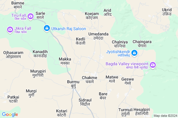
Pokhertoli Map
EDIT Map
Add Your House
 ..
..
Current Corona Virus Infected Patients Count in Ranchi District
| City Name | District Name | Total Covid cases |
|---|---|---|
| Ranchi District | Ranchi | 32 |
| Hindpiri | Ranchi | 12 |
| Hindipiri | Ranchi | 5 |
| Hindpidi | Ranchi | 2 |
| Lowadih | Ranchi | 2 |
| Azad Basti | Ranchi | 2 |
Locality Name :
Pokhertoli
( पोखरटोली )
Block Name : Burmu
District : Ranchi
State : Jharkhand
Language : Hindi and Urdu, Bengali, Asuri, Munda
Current Time 01:31 PM
Date: Wednesday , Apr 30,2025 (IST)
Time zone: IST (UTC+5:30)
Elevation / Altitude: 447 meters. Above Seal level
Telephone Code / Std Code: 06530
Assembly constituency : Kanke assembly constituency
Assembly MLA : SAMMARI LAL
Lok Sabha constituency : Ranchi parliamentary constituency
Parliament MP : SANJAY SETH
Serpanch Name :
Main Village Name : Ithe
Commodities Prices : Khunti Market / Mandi
Pokhertoli Live Weather
Temperature: 35.2 °C
clear sky
Humidity: 21%
Wind : 2.49 mt/sec towards S
StationName : "RÄ\u0081y"
observed on 16 Mins Back
Temperature: 35.2 °C
clear sky
Humidity: 21%
Wind : 2.49 mt/sec towards S
StationName : "RÄ\u0081y"
observed on 16 Mins Back
Pokhertoli Weather Forecast for Next 5 days
01-05-2025
23.3°C to 35.3°C
clear sky, light rain, scattered clouds
23.3°C to 35.3°C
clear sky, light rain, scattered clouds
02-05-2025
21.1°C to 34.6°C
clear sky, light rain, moderate rain, overcast clouds, scattered clouds
21.1°C to 34.6°C
clear sky, light rain, moderate rain, overcast clouds, scattered clouds
03-05-2025
20.9°C to 35.1°C
few clouds, clear sky, scattered clouds, light rain
20.9°C to 35.1°C
few clouds, clear sky, scattered clouds, light rain
04-05-2025
23.8°C to 36.8°C
clear sky, light rain, broken clouds, scattered clouds
23.8°C to 36.8°C
clear sky, light rain, broken clouds, scattered clouds
05-05-2025
24.4°C to 37.2°C
clear sky, broken clouds, light rain, scattered clouds, overcast clouds
24.4°C to 37.2°C
clear sky, broken clouds, light rain, scattered clouds, overcast clouds
Rivers Near Pokhertoli
Saphi Nadi
Damodar
Saphi Nadi
Damodar
About Pokhertoli
Correct below Info and add more info about PokhertoliPokhertoli is a small Village/hamlet in Burmu Block in Ranchi District of Jharkhand State, India. It comes under Ithe Panchayath. It is located 39 KM towards North from District head quarters Ranchi. 38 KM from State capital Ranchi
Pokhertoli is surrounded by Patratu Block towards East , Mandar Block towards South , Chanho Block towards west , Ratu Block towards South .
Patratu , Churi , Saunda , Ranchi are the near by Cities to Pokhertoli.
This Place is in the border of the Ranchi District and Ramgarh District. Ramgarh District Patratu is East towards this place .
Demographics of Pokhertoli
Hindi is the Local Language here.Politics in Pokhertoli
Bharatiya Janata Party , BJP , INC are the major political parties in this area.Polling Stations /Booths near Pokhertoli
1)Govt. Basic School Kanke2)Govt. Pri. School Soba
3)Govt. P.s. Marwa
4)Govt. Pri. School Patkoi
5)Govt. Middle Sch. Umedanda (middle Part)
HOW TO REACH Pokhertoli
By Rail
There is no railway station near to Pokhertoli in less than 10 km.Pincodes near Pokhertoli
829209 ( Ray ) , 835205 ( Brambe ) , 829205 ( Khalari )Colleges near Pokhertoli
R.t.c Inter College Turmuli
Address :
Schools near Pokhertoli
D.a.v Public School Hesalpiri
Address : Near panchayat bhavan hesalpiri
Sachindra Choudhry High School Hesalpiri
Address : Hesalpiri
Sachindra Institute Of Technology
Address : Near deepak kirana storê
Rtc High School Turmuli
Address : near hesalpiri
Govt Health Centers near Pokhertoli
1) HSC CHAMAY , HSC Chakme , Chakme , Chakme Talab2) HSC MAKKA , HSC MAKKA , MAKKA ,
3) CHC BURMU , Burmu , Burmu , Burmu Block
Hospitals in Pokhertoli,Burmu
Community Health Center
Burmu; Ranchi; Ratu Road; Ranchi; Ranchi; Jharkhand 835214; India
4.4 KM distance Detail
Rajkiya Ayurvedic Hospital
Burmu; Ranchi; Ratu Road; Ranchi; Ranchi; Jharkhand 835214; India
4.4 KM distance Detail
more ..
Colleges in Pokhertoli,Burmu
Nilaai Educational Trusts Group of Institutions
Ginjo Thakurgaon; Jharkhand 835205; India
9.5 KM distance Detail
more ..
Super Markets in Pokhertoli,Burmu
Rajesh jaiswal seed and fertilizers shop
Burmu; Umedanda; Jharkhand 829209; India
3.6 KM distance Detail
Police Stations near Pokhertoli,Burmu
Burmu Police Station
Burmu Chowk; Main Road; Burmu; Ranchi; Jharkhand 835214; India
4.5 KM distance Detail
Governement Offices near Pokhertoli,Burmu
Makka Gram Panchyat
835214; Macca Masjid Rd; Nizam Nagar; Hindpiri; Ranchi; Jharkhand 834001; India
1.9 KM distance Detail
About Pokhertoli &
History
How to reach Pokhertoli
Tourist Places Near By Pokhertoli
Schools in Pokhertoli
Colleges in Pokhertoli
Temperature & weather of Pokhertoli
places in Pokhertoli
Pokhertoli photos
More Information
How to reach Pokhertoli
Tourist Places Near By Pokhertoli
Schools in Pokhertoli
Colleges in Pokhertoli
Temperature & weather of Pokhertoli
places in Pokhertoli
Pokhertoli photos
More Information
Village Talk
Post News or Events about this Village
Near Cities
Patratu 15 KM near
Churi 16 KM near
Saunda 24 KM near
Ranchi 37 KM near
Patratu 15 KM near
Churi 16 KM near
Saunda 24 KM near
Ranchi 37 KM near
Near By Taluks
Burmu 0 KM near
Patratu 18 KM near
Mandar 23 KM near
Chanho 23 KM near
Burmu 0 KM near
Patratu 18 KM near
Mandar 23 KM near
Chanho 23 KM near
Near By Air Ports
Ranchi Airport 40 KM near
Gaya Airport 144 KM near
Patna Airport 248 KM near
Varanasi Airport 347 KM near
Ranchi Airport 40 KM near
Gaya Airport 144 KM near
Patna Airport 248 KM near
Varanasi Airport 347 KM near
Near By Tourist Places
Ranchi 36 KM near
Lohardaga 57 KM near
Dassam Falls 65 KM near
Chotanagpur 75 KM near
Latehar 77 KM near
Ranchi 36 KM near
Lohardaga 57 KM near
Dassam Falls 65 KM near
Chotanagpur 75 KM near
Latehar 77 KM near
Near By Districts
Ranchi 37 KM near
Ramgarh 40 KM near
Hazaribagh 54 KM near
Lohardaga 57 KM near
Ranchi 37 KM near
Ramgarh 40 KM near
Hazaribagh 54 KM near
Lohardaga 57 KM near
Near By RailWay Station
Ray Rail Way Station 13 KM near
Khalari Rail Way Station 18 KM near
Ray Rail Way Station 13 KM near
Khalari Rail Way Station 18 KM near