| Home | City Bus | Maps | Villages | Cities | Rail | Tourist Places | School | College | Pin Codes | Corona Cases Count |
| Distance Calculator Bus Services IFSC Codes Trace Mobile Number Weather Search Place Trace IP Available Cash ATM/Banks Locate Polling Booth Report an Error contact People |
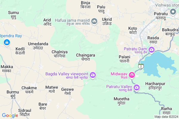
Dahutoli Map
EDIT Map
Add Your House
 ..
..
Current Corona Virus Infected Patients Count in Ranchi District
| City Name | District Name | Total Covid cases |
|---|---|---|
| Ranchi District | Ranchi | 32 |
| Hindpiri | Ranchi | 12 |
| Hindipiri | Ranchi | 5 |
| Hindpidi | Ranchi | 2 |
| Lowadih | Ranchi | 2 |
| Azad Basti | Ranchi | 2 |
Locality Name :
Dahutoli
( दाहुतोली )
Block Name : Burmu
District : Ranchi
State : Jharkhand
Language : Hindi and Urdu, Bengali, Asuri, Munda
Current Time 01:42 PM
Date: Wednesday , Apr 30,2025 (IST)
Time zone: IST (UTC+5:30)
Elevation / Altitude: 447 meters. Above Seal level
Telephone Code / Std Code: 06530
Assembly constituency : Kanke assembly constituency
Assembly MLA : SAMMARI LAL
Lok Sabha constituency : Ranchi parliamentary constituency
Parliament MP : SANJAY SETH
Serpanch Name :
Pin Code : 829209
Post Office Name : Ray
Main Village Name : Chaingara
Commodities Prices : Khunti Market / Mandi
Dahutoli Live Weather
Temperature: 34.7 °C
clear sky
Humidity: 21%
Wind : 3.12 mt/sec towards SW
StationName : "RÄ\u0081y"
observed on Now
Temperature: 34.7 °C
clear sky
Humidity: 21%
Wind : 3.12 mt/sec towards SW
StationName : "RÄ\u0081y"
observed on Now
Dahutoli Weather Forecast for Next 5 days
01-05-2025
24.6°C to 36.8°C
clear sky, light rain, scattered clouds
24.6°C to 36.8°C
clear sky, light rain, scattered clouds
02-05-2025
22.3°C to 36.2°C
clear sky, light rain, moderate rain, overcast clouds, scattered clouds
22.3°C to 36.2°C
clear sky, light rain, moderate rain, overcast clouds, scattered clouds
03-05-2025
22.2°C to 36.5°C
few clouds, clear sky, scattered clouds, light rain
22.2°C to 36.5°C
few clouds, clear sky, scattered clouds, light rain
04-05-2025
25.2°C to 38.2°C
clear sky, light rain, broken clouds, scattered clouds, few clouds
25.2°C to 38.2°C
clear sky, light rain, broken clouds, scattered clouds, few clouds
05-05-2025
25.7°C to 38.8°C
clear sky, broken clouds, overcast clouds, scattered clouds
25.7°C to 38.8°C
clear sky, broken clouds, overcast clouds, scattered clouds
Rivers Near Dahutoli
Saphi Nadi
Damodar
Saphi Nadi
Damodar
About Dahutoli
Correct below Info and add more info about DahutoliDahutoli is a small Village/hamlet in Burmu Block in Ranchi District of Jharkhand State, India. It comes under Chaingara Panchayath. It is located 37 KM towards North from District head quarters Ranchi. 8 KM from Burmu. 36 KM from State capital Ranchi
Dahutoli Pin code is 829209 and postal head office is Ray .
Dahutoli is surrounded by Patratu Block towards East , Kanke Block towards South , Ratu Block towards South , Mandar Block towards South .
Patratu , Saunda , Churi , Ramngarh are the near by Cities to Dahutoli.
This Place is in the border of the Ranchi District and Ramgarh District. Ramgarh District Patratu is East towards this place .
Demographics of Dahutoli
Hindi is the Local Language here.Politics in Dahutoli
Bharatiya Janata Party , BJP , INC are the major political parties in this area.Polling Stations /Booths near Dahutoli
1)Govt. Midd. Sch. Burmu(east Part)2)Govt. Midd. Sch. Burmu(middle Part)
3)Don Bosco School Kokar Khorhatoli Room No-4
4)Govt. Midd. Sch. Chakme ( West Part)
5)Govt. Midd. Sch. Burmu(west Part)
HOW TO REACH Dahutoli
By Rail
Tokisud Rail Way Station is the very nearby railway stations to Dahutoli.Colleges near Dahutoli
R.t.c Inter College Turmuli
Address :
Schools near Dahutoli
D.a.v Public School Hesalpiri
Address : Near panchayat bhavan hesalpiri
Sachindra Choudhry High School Hesalpiri
Address : Hesalpiri
Sachindra Institute Of Technology
Address : Near deepak kirana storê
Rtc High School Turmuli
Address : near hesalpiri
Govt Health Centers near Dahutoli
1) HSC CHAINGADA , HSC CHAINGADA , CHAINGADA , CHAINGADA PANCHYAT BHAWAN2) HSC HAPHUA , , ,
3) HSC GUSURAY , HSC Geswe , Geswe , Kisan High School
Colleges in Dahutoli,Burmu
Gridih College
Ranchi Patratu Ramgarh Rd; Kodram; Patratu; Jharkhand 829119; India
7.1 KM distance Detail
more ..
Electronic Shops in Dahutoli,Burmu
ASHOK DJ SOUND BARTUWA; PATRATU; RAMGARH
Bartuwa; Patratu; Jharkhand 829119; India
4.9 KM distance Detail
Super Markets in Dahutoli,Burmu
Ranchi Town
Ranchi Patratu Ramgarh Rd; Kodram; Patratu; Jharkhand 829119; India
7.1 KM distance Detail
Police Stations near Dahutoli,Burmu
Burmu Police Station
Burmu Chowk; Main Road; Burmu; Ranchi; Jharkhand 835214; India
11.7 KM distance Detail
Governement Offices near Dahutoli,Burmu
Makka Gram Panchyat
835214; Macca Masjid Rd; Nizam Nagar; Hindpiri; Ranchi; Jharkhand 834001; India
10.3 KM distance Detail
Panchayat Sachiwalaya Sankul
Sankul Patratu Road; Patratu; Jharkhand 829118; India
11.6 KM distance Detail
About Dahutoli &
History
How to reach Dahutoli
Tourist Places Near By Dahutoli
Schools in Dahutoli
Colleges in Dahutoli
Temperature & weather of Dahutoli
places in Dahutoli
Dahutoli photos
More Information
How to reach Dahutoli
Tourist Places Near By Dahutoli
Schools in Dahutoli
Colleges in Dahutoli
Temperature & weather of Dahutoli
places in Dahutoli
Dahutoli photos
More Information
Village Talk
Post News or Events about this Village
Near Cities
Patratu 7 KM near
Saunda 16 KM near
Churi 22 KM near
Ramngarh 29 KM near
Patratu 7 KM near
Saunda 16 KM near
Churi 22 KM near
Ramngarh 29 KM near
Near By Taluks
Burmu 8 KM near
Patratu 9 KM near
Kanke 22 KM near
Ratu 27 KM near
Burmu 8 KM near
Patratu 9 KM near
Kanke 22 KM near
Ratu 27 KM near
Near By Air Ports
Ranchi Airport 38 KM near
Gaya Airport 144 KM near
Patna Airport 247 KM near
Varanasi Airport 352 KM near
Ranchi Airport 38 KM near
Gaya Airport 144 KM near
Patna Airport 247 KM near
Varanasi Airport 352 KM near
Near By Tourist Places
Ranchi 34 KM near
Dassam Falls 61 KM near
Lohardaga 65 KM near
Chotanagpur 78 KM near
Chatra 83 KM near
Ranchi 34 KM near
Dassam Falls 61 KM near
Lohardaga 65 KM near
Chotanagpur 78 KM near
Chatra 83 KM near
Near By Districts
Ramgarh 32 KM near
Ranchi 35 KM near
Hazaribagh 50 KM near
Lohardaga 65 KM near
Ramgarh 32 KM near
Ranchi 35 KM near
Hazaribagh 50 KM near
Lohardaga 65 KM near
Near By RailWay Station
Tokisud Rail Way Station 9.2 KM near
Patratu Rail Way Station 12 KM near
Ray Rail Way Station 19 KM near
Tokisud Rail Way Station 9.2 KM near
Patratu Rail Way Station 12 KM near
Ray Rail Way Station 19 KM near