| Home | City Bus | Maps | Villages | Cities | Rail | Tourist Places | School | College | Pin Codes | Corona Cases Count |
| Distance Calculator Bus Services IFSC Codes Trace Mobile Number Weather Search Place Trace IP Available Cash ATM/Banks Locate Polling Booth Report an Error contact People |
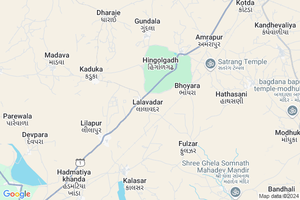
Lalavadar Map
EDIT Map
Add Your House
 ..
..
Current Corona Virus Infected Patients Count in Rajkot District
| City Name | District Name | Total Covid cases |
|---|---|---|
| Rajkot District | Rajkot | 38 |
| Rajkot | Rajkot | 7 |
Locality Name :
Lalavadar
( લાલાવદર )
Taluka Name : Jasdan
District : Rajkot
State : Gujarat
Language : Gujarati and Hindi, Urdu, English, Sindhi, Bengali, Tamil, Malayalam And Marathi
Current Time 10:59 AM
Date: Sunday , Apr 27,2025 (IST)
Time zone: IST (UTC+5:30)
Elevation / Altitude: 165 meters. Above Seal level
Telephone Code / Std Code: 02821
Assembly constituency : Jasdan assembly constituency
Assembly MLA : Kunvarjibhai Mohanbhai Bavaliya
Lok Sabha constituency : Rajkot parliamentary constituency
Parliament MP : KUNDARIA MOHANBHAI KALYANJIBHAI
Serpanch Name :
Pin Code : 360050
Post Office Name : Jasdan
Commodities Prices : Jasdan Market / Mandi
Edit below overview about Lalavadar
Edit below overview about Lalavadar
OverView of Lalavadar
lalavadar village near hingolgadh hill station. It is the small village. There is a small pond. most of people of lalavadar are farmers. They are very simple person. The population of lalavadar is 3000. There is small school. There is an old hospital. There is jay gurudev ashram. Tourists can rest their. PRATIK AND DARSHIT KATESHIYA.Edit below overview about Lalavadar
National Highways Reachable To Lalavadar
Nationa High Way :NH27
Nationa High Way :NH27
Rivers Near Lalavadar
Aji :આજી
Aji :આજી
Aji :આજી
Aji :આજી
About Lalavadar
Lalavadar is a Village in Jasdan Taluka in Rajkot District of Gujarat State, India. It is located 65 KM towards East from District head quarters Rajkot. 8 KM from . 215 KM from State capital Gandhinagar
Lalavadar Pin code is 360050 and postal head office is Jasdan .
Hingolgadh ( 3 KM ) , Bhonyra ( 4 KM ) , Fulzar ( 4 KM ) , Lilapur ( 4 KM ) , Kaduka ( 5 KM ) are the nearby Villages to Lalavadar. Lalavadar is surrounded by Babra Taluka towards South , Chotila Taluka towards North , Botad Taluka towards East , Gadhada Taluka towards East .
Lathi , Thangadh , Rajkot , Amreli are the near by Cities to Lalavadar.
Lalavadar 2011 Census Details
Lalavadar Local Language is Gujarati. Lalavadar Village Total population is 1155 and number of houses are 219. Female Population is 47.3%. Village literacy rate is 60.0% and the Female Literacy rate is 23.8%.
Population
| Census Parameter | Census Data |
| Total Population | 1155 |
| Total No of Houses | 219 |
| Female Population % | 47.3 % ( 546) |
| Total Literacy rate % | 60.0 % ( 693) |
| Female Literacy rate | 23.8 % ( 275) |
| Scheduled Tribes Population % | 0.0 % ( 0) |
| Scheduled Caste Population % | 1.6 % ( 19) |
| Working Population % | 54.5 % |
| Child(0 -6) Population by 2011 | 138 |
| Girl Child(0 -6) Population % by 2011 | 47.1 % ( 65) |
Lalavadar Census More Deatils.
Politics in Lalavadar
BJP , INC are the major political parties in this area.Polling Stations /Booths near Lalavadar
1)Kundani2)Karmal Kotada
3)Bhdali-3
4)Lilapur-1
5)Lalavdar
HOW TO REACH Lalavadar
By Rail
There is no railway station near to Lalavadar in less than 10 km.Colleges near Lalavadar
Government Arts And Commerce Colledge
Address :
Sarvopari Science College
Address :
Shri Hn And Rn Doshi
Address :
Nanibrar Kumar Sala
Address :
Creation Bsw / Msw College
Address :
Schools in Lalavadar
Lalavadar Primary School
Address : lalavadar , jasdan , rajkot , Gujarat . PIN- 360050 , Post - Jasdan
Govt Health Centers near Lalavadar
1) Dhokadava , subcenter -Dhokadava , ,2) Vadali , Subcenter -Vadali , ,
3) Pipliya(Dho) , Subcenter -Pipliya(Dho) , ,
Hospitals in Lalavadar,Jasdan
shree Ram Hospital. Health Centre
Jasdan - Vinchhiya Rd; Lilapur; Gujarat 360050; India
5.0 KM distance Detail
more ..
Colleges in Lalavadar,Jasdan
Hari Baapa College
lati plot; SH 119; Lati Plot; Rameswara Nagar; Jasdan; Gujarat 360050; India
16.6 KM distance Detail
more ..
Local Parks in Lalavadar,Jasdan
Hingolgadh Nature Education Sanctuary
Jasdan-Ahmedabad highway; Taluka Vinchhiya; Post Amarapur; Rajkot District; Hingolgadh; Gujarat 360055; India
3.1 KM distance Detail
Police Stations near Lalavadar,Jasdan
Vajsurpara Police Station
main road;VAJSURPARA; Vajsurpara; Jasdan; Gujarat 360050; India
16.5 KM distance Detail
About Lalavadar &
History
How to reach Lalavadar
Tourist Places Near By Lalavadar
Schools in Lalavadar
Colleges in Lalavadar
Temperature & weather of Lalavadar
places in Lalavadar
Lalavadar photos
More Information
How to reach Lalavadar
Tourist Places Near By Lalavadar
Schools in Lalavadar
Colleges in Lalavadar
Temperature & weather of Lalavadar
places in Lalavadar
Lalavadar photos
More Information
Village Talk
Post News or Events about this Village
Near Cities
Lathi 51 KM near
Thangadh 56 KM near
Rajkot 62 KM near
Amreli 65 KM near
Lathi 51 KM near
Thangadh 56 KM near
Rajkot 62 KM near
Amreli 65 KM near
Near By Taluks
Jasdan 8 KM near
Babra 29 KM near
Chotila 34 KM near
Botad 35 KM near
Jasdan 8 KM near
Babra 29 KM near
Chotila 34 KM near
Botad 35 KM near
Near By Air Ports
Civil Airport 64 KM near
Bhavnagar Airport 111 KM near
Govardhanpur Airport 155 KM near
Diu Airport 181 KM near
Civil Airport 64 KM near
Bhavnagar Airport 111 KM near
Govardhanpur Airport 155 KM near
Diu Airport 181 KM near
Near By Tourist Places
Gondal 62 KM near
Rajkot 64 KM near
Wankaner 73 KM near
Surendranagar 86 KM near
Palitana 95 KM near
Gondal 62 KM near
Rajkot 64 KM near
Wankaner 73 KM near
Surendranagar 86 KM near
Palitana 95 KM near
Near By Districts
Rajkot 63 KM near
Amreli 65 KM near
Surendranagar 82 KM near
Bhavnagar 103 KM near
Rajkot 63 KM near
Amreli 65 KM near
Surendranagar 82 KM near
Bhavnagar 103 KM near
Near By RailWay Station
Botad Junction Rail Way Station 41 KM near
Than Junction Rail Way Station 57 KM near
Botad Junction Rail Way Station 41 KM near
Than Junction Rail Way Station 57 KM near