| Home | City Bus | Maps | Villages | Cities | Rail | Tourist Places | School | College | Pin Codes | Corona Cases Count |
| Distance Calculator Bus Services IFSC Codes Trace Mobile Number Weather Search Place Trace IP Available Cash ATM/Banks Locate Polling Booth Report an Error contact People |
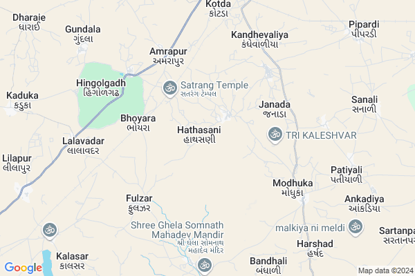
Hathasani Map
EDIT Map
Add Your House
 ..
..
Current Corona Virus Infected Patients Count in Rajkot District
| City Name | District Name | Total Covid cases |
|---|---|---|
| Rajkot District | Rajkot | 38 |
| Rajkot | Rajkot | 7 |
Locality Name :
Hathasani
( હાથસણી )
Taluka Name : Jasdan
District : Rajkot
State : Gujarat
Language : Gujarati and Hindi, Urdu, English, Sindhi, Bengali, Tamil, Malayalam And Marathi
Current Time 11:43 AM
Date: Wednesday , Apr 30,2025 (IST)
Time zone: IST (UTC+5:30)
Elevation / Altitude: 165 meters. Above Seal level
Telephone Code / Std Code: 02821
Assembly constituency : Jasdan assembly constituency
Assembly MLA : Kunvarjibhai Mohanbhai Bavaliya
Lok Sabha constituency : Rajkot parliamentary constituency
Parliament MP : KUNDARIA MOHANBHAI KALYANJIBHAI
Serpanch Name :
Pin Code : 360055
Post Office Name : Vinchhiya
Commodities Prices : Jasdan Market / Mandi
National Highways Reachable To Hathasani
Nationa High Way :NH27
Nationa High Way :NH27
Rivers Near Hathasani
Aji :આજી
Aji :આજી
Aji :આજી
Aji :આજી
About Hathasani
Correct below Info and add more info about HathasaniHathasani is a Village in Jasdan Taluka in Rajkot District of Gujarat State, India. It is located 72 KM towards East from District head quarters Rajkot. 15 KM from . 210 KM from State capital Gandhinagar
Hathasani Pin code is 360055 and postal head office is Vinchhiya .
Amrapur ( 5 KM ) , Fulzar ( 5 KM ) , Bhonyra ( 5 KM ) , Modhuka ( 6 KM ) , Hingolgadh ( 6 KM ) are the nearby Villages to Hathasani. Hathasani is surrounded by Botad Taluka towards East , Babra Taluka towards South , Gadhada Taluka towards East , Chotila Taluka towards North .
Lathi , Thangadh , Amreli , Rajkot are the near by Cities to Hathasani.
Hathasani 2011 Census Details
Hathasani Local Language is Gujarati. Hathasani Village Total population is 3480 and number of houses are 712. Female Population is 48.3%. Village literacy rate is 46.4% and the Female Literacy rate is 17.8%.
Population
| Census Parameter | Census Data |
| Total Population | 3480 |
| Total No of Houses | 712 |
| Female Population % | 48.3 % ( 1682) |
| Total Literacy rate % | 46.4 % ( 1614) |
| Female Literacy rate | 17.8 % ( 621) |
| Scheduled Tribes Population % | 0.3 % ( 11) |
| Scheduled Caste Population % | 1.6 % ( 56) |
| Working Population % | 44.3 % |
| Child(0 -6) Population by 2011 | 533 |
| Girl Child(0 -6) Population % by 2011 | 47.1 % ( 251) |
Hathasani Census More Deatils.
Politics in Hathasani
BJP , INC are the major political parties in this area.Polling Stations /Booths near Hathasani
1)Hadmatia Khanda2)Hathasni-1
3)Bhdali-3
4)Amrapur-2
5)Amrapur-1
HOW TO REACH Hathasani
By Rail
There is no railway station near to Hathasani in less than 10 km.Colleges near Hathasani
Government Arts And Commerce Colledge
Address :
Sarvopari Science College
Address :
Shri Hn And Rn Doshi
Address :
Nanibrar Kumar Sala
Address :
Creation Bsw / Msw College
Address :
Schools near Hathasani
Moti Lakhavad Kanya Primary Sc
Address : moti lakhavad , jasdan , rajkot , Gujarat . PIN- 360055 , Post - Vinchhiya
Jaymohan Dada Vidhiyalay
Address : lilapur , jasdan , rajkot , Gujarat . PIN- 360050 , Post - Jasdan
Nutan Sarasvati Vidhyalaya
Address : jasdan , jasdan , rajkot , Gujarat . PIN- 360050 , Post - Jasdan
Siddharth Vidhyabhavan
Address : atkot , jasdan , rajkot , Gujarat . PIN- 360040 , Post - Atkot
Govt Health Centers near Hathasani
1) Dhokadava , subcenter -Dhokadava , ,2) Ninama , SubCentar-Ninama , , Near Watar tank
3) Kashvali , SubCentar-Kashvali , , Opp Primary School
Colleges in Hathasani,Jasdan
Hari Baapa College
lati plot; SH 119; Lati Plot; Rameswara Nagar; Jasdan; Gujarat 360050; India
22.3 KM distance Detail
more ..
Schools in Hathasani,Jasdan
Amrapur Kumar Taluka School
Jasdan - Vinchhiya Rd; Amrapur; Gujarat 360055; India
4.7 KM distance Detail
Local Parks in Hathasani,Jasdan
Hingolgadh Nature Education Sanctuary
Jasdan-Ahmedabad highway; Taluka Vinchhiya; Post Amarapur; Rajkot District; Hingolgadh; Gujarat 360055; India
7.0 KM distance Detail
Police Stations near Hathasani,Jasdan
Vajsurpara Police Station
main road;VAJSURPARA; Vajsurpara; Jasdan; Gujarat 360050; India
22.4 KM distance Detail
About Hathasani &
History
How to reach Hathasani
Tourist Places Near By Hathasani
Schools in Hathasani
Colleges in Hathasani
Temperature & weather of Hathasani
places in Hathasani
Hathasani photos
More Information
How to reach Hathasani
Tourist Places Near By Hathasani
Schools in Hathasani
Colleges in Hathasani
Temperature & weather of Hathasani
places in Hathasani
Hathasani photos
More Information
Village Talk
Post News or Events about this Village
Near Cities
Lathi 50 KM near
Thangadh 58 KM near
Amreli 67 KM near
Rajkot 69 KM near
Lathi 50 KM near
Thangadh 58 KM near
Amreli 67 KM near
Rajkot 69 KM near
Near By Taluks
Jasdan 15 KM near
Botad 28 KM near
Babra 32 KM near
Gadhada 32 KM near
Jasdan 15 KM near
Botad 28 KM near
Babra 32 KM near
Gadhada 32 KM near
Near By Air Ports
Civil Airport 71 KM near
Bhavnagar Airport 105 KM near
Govardhanpur Airport 161 KM near
Diu Airport 183 KM near
Civil Airport 71 KM near
Bhavnagar Airport 105 KM near
Govardhanpur Airport 161 KM near
Diu Airport 183 KM near
Near By Tourist Places
Gondal 68 KM near
Rajkot 70 KM near
Wankaner 77 KM near
Surendranagar 83 KM near
Palitana 91 KM near
Gondal 68 KM near
Rajkot 70 KM near
Wankaner 77 KM near
Surendranagar 83 KM near
Palitana 91 KM near
Near By Districts
Amreli 66 KM near
Rajkot 69 KM near
Surendranagar 79 KM near
Bhavnagar 96 KM near
Amreli 66 KM near
Rajkot 69 KM near
Surendranagar 79 KM near
Bhavnagar 96 KM near
Near By RailWay Station
Botad Junction Rail Way Station 34 KM near
Dhola Junction Rail Way Station 57 KM near
Botad Junction Rail Way Station 34 KM near
Dhola Junction Rail Way Station 57 KM near