| Home | City Bus | Maps | Villages | Cities | Rail | Tourist Places | School | College | Pin Codes | Corona Cases Count |
| Distance Calculator Bus Services IFSC Codes Trace Mobile Number Weather Search Place Trace IP Available Cash ATM/Banks Locate Polling Booth Report an Error contact People |
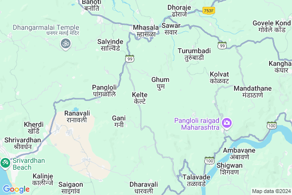
Kelte
Kelte Map
EDIT Map
Add Your House
 ..
..
Current Corona Virus Infected Patients Count in Raigad District
| City Name | District Name | Total Covid cases |
|---|
Locality Name :
Kelte
( केलते )
Taluka Name : Mhasala
District : Raigad
State : Maharashtra
Region : Konkan
Division : Konkan
Language : Marathi and Hindi
Current Time 08:34 AM
Date: Wednesday , Apr 30,2025 (IST)
Time zone: IST (UTC+5:30)
Elevation / Altitude: 13 meters. Above Seal level
Telephone Code / Std Code: 02149
Assembly constituency : Shrivardhan assembly constituency
Assembly MLA : Aditi Sunil Tatkare
Lok Sabha constituency : Raigad parliamentary constituency
Parliament MP : Tatkare Sunil Dattatray
Serpanch Name :
Pin Code : 402105
Post Office Name : Mhasla
Commodities Prices : Mangaon Market / Mandi
Kelte Live Weather
Temperature: 25.2 °C
clear sky
Humidity: 75%
Wind : 1.14 mt/sec towards NE
StationName : "Mhasla"
observed on 37 Mins Back
Temperature: 25.2 °C
clear sky
Humidity: 75%
Wind : 1.14 mt/sec towards NE
StationName : "Mhasla"
observed on 37 Mins Back
Kelte Weather Forecast for Next 5 days
01-05-2025
26.1°C to 35.5°C
clear sky
26.1°C to 35.5°C
clear sky
02-05-2025
25.4°C to 35.3°C
clear sky, few clouds
25.4°C to 35.3°C
clear sky, few clouds
03-05-2025
25.4°C to 35.6°C
few clouds, clear sky
25.4°C to 35.6°C
few clouds, clear sky
04-05-2025
25.3°C to 35.0°C
clear sky, scattered clouds, broken clouds
25.3°C to 35.0°C
clear sky, scattered clouds, broken clouds
05-05-2025
25.3°C to 33.5°C
clear sky, few clouds
25.3°C to 33.5°C
clear sky, few clouds
National Highways Reachable To Kelte
Nationa High Way :NH965DD
Nationa High Way :NH66
Nationa High Way :NH965DD
Nationa High Way :NH66
Rivers Near Kelte
Savitri River
Savitri River
Savitri River
Savitri River
About Kelte
Correct below Info and add more info about KelteKelte is a Village in Mhasala Taluka in Raigad District of Maharashtra State, India. It belongs to Konkan region . It belongs to Konkan Division . It is located 78 KM towards South from District head quarters Alibag. 5 KM from Mhasala. 124 KM from State capital Mumbai
Kelte Pin code is 402105 and postal head office is Mhasla .
Nevrul ( 2 KM ) , Gani ( 2 KM ) , Pangloli ( 3 KM ) , Jambhul ( 3 KM ) , Vadghar ( 3 KM ) are the nearby Villages to Kelte. Kelte is surrounded by Shrivardhan Taluka towards west , Mandangad Taluka towards South , Tala Taluka towards North , Mangaon Taluka towards East .
Mahad , Nandgaon , Mahabaleswar , Pen are the near by Cities to Kelte.
It is near to arabian sea. There is a chance of humidity in the weather.
Kelte 2011 Census Details
Kelte Local Language is Marathi. Kelte Village Total population is 681 and number of houses are 186. Female Population is 64.9%. Village literacy rate is 63.1% and the Female Literacy rate is 39.1%.
Population
| Census Parameter | Census Data |
| Total Population | 681 |
| Total No of Houses | 186 |
| Female Population % | 64.9 % ( 442) |
| Total Literacy rate % | 63.1 % ( 430) |
| Female Literacy rate | 39.1 % ( 266) |
| Scheduled Tribes Population % | 6.6 % ( 45) |
| Scheduled Caste Population % | 12.8 % ( 87) |
| Working Population % | 41.3 % |
| Child(0 -6) Population by 2011 | 91 |
| Girl Child(0 -6) Population % by 2011 | 52.7 % ( 48) |
Kelte Census More Deatils.
Politics in Kelte
Nationalist Congress Party , NCP , SHS , INC are the major political parties in this area.Polling Stations /Booths near Kelte
1)Kashene2)Ghotwal
3)Nanvali
4)Galsure
5)Kondepanchatan
HOW TO REACH Kelte
By Rail
There is no railway station near to Kelte in less than 10 km. are the Rail way stations reachable from near by towns.By Road
Shrivardhan are the nearby by towns to Kelte having road connectivity to KelteColleges near Kelte
S A K Juniour College Pangloli
Address :
Vasant Rao Naik College
Address :
Schools in Kelte
Prabhakar Patil Edu. Soct.kele
Address : kelte , mhasala , raigarh (maharashtra) , Maharashtra . PIN- 402105 , Post - Mhasla
R.z.p. School Kelte
Address : kelte , mhasala , raigarh (maharashtra) , Maharashtra . PIN- 402105 , Post - Mhasla
Govt Health Centers near Kelte
1) Nevrul , Sc Nevrul , At-Nevrul,post-Kelte, l Nevrul , in front of lad chaul2) Jambhul , Sc Jambhul , At-Post-Jambhul Jambhul Near Samaj Mandir , At-Post-Jambhul Jambhul Near Samaj Mandir
3) Mhasala , PHC Mhasala , Behind ST Stand mhasala , Behind ST Stand Mhasala
Sub Villages in Kelte
Hospitals in Kelte,Mhasala
Dhanvantari Hospital; Maternity clinic Ozone Therapy centre
Mhapral; Maharashtra 415203; India
21.6 KM distance Detail
more ..
Colleges in Kelte,Mhasala
Loknete Gopinathji Munde Arts Commerce and Science College
Mandangad; Maharashtra 415203; India
23.1 KM distance Detail
more ..
Schools in Kelte,Mhasala
Anjuman urdu high school
At Wani; Post Purar; Tal Mangaon Dist Raigad 402103; Nandavi - Kestuli Road; Madhegaon; Maharashtra 402103; India
21.9 KM distance Detail
About Kelte &
History
How to reach Kelte
Tourist Places Near By Kelte
Schools in Kelte
Colleges in Kelte
Temperature & weather of Kelte
places in Kelte
Kelte photos
More Information
How to reach Kelte
Tourist Places Near By Kelte
Schools in Kelte
Colleges in Kelte
Temperature & weather of Kelte
places in Kelte
Kelte photos
More Information
Village Talk
Post News or Events about this Village
Near Cities
Mahad 33 KM near
Nandgaon 42 KM near
Mahabaleswar 67 KM near
Pen 80 KM near
Mahad 33 KM near
Nandgaon 42 KM near
Mahabaleswar 67 KM near
Pen 80 KM near
Near By Taluks
Mhasala 4 KM near
Shrivardhan 10 KM near
Mandangad 20 KM near
Tala 24 KM near
Mhasala 4 KM near
Shrivardhan 10 KM near
Mandangad 20 KM near
Tala 24 KM near
Near By Air Ports
Lohegaon Airport 113 KM near
Chhatrapati Shivaji International Airport 128 KM near
Kolhapur Airport 229 KM near
Gandhinagar Airport 247 KM near
Lohegaon Airport 113 KM near
Chhatrapati Shivaji International Airport 128 KM near
Kolhapur Airport 229 KM near
Gandhinagar Airport 247 KM near
Near By Tourist Places
Shrivardhan 12 KM near
Harihareshwar 15 KM near
Murud Janjira 31 KM near
Harnai 39 KM near
Kolad 41 KM near
Shrivardhan 12 KM near
Harihareshwar 15 KM near
Murud Janjira 31 KM near
Harnai 39 KM near
Kolad 41 KM near
Near By Districts
Raigad 75 KM near
Pune 104 KM near
Mumbai 114 KM near
Satara 116 KM near
Raigad 75 KM near
Pune 104 KM near
Mumbai 114 KM near
Satara 116 KM near
Near By RailWay Station
Veer Rail Way Station 26 KM near
Mangaon Rail Way Station 27 KM near
Veer Rail Way Station 26 KM near
Mangaon Rail Way Station 27 KM near