| Home | City Bus | Maps | Villages | Cities | Rail | Tourist Places | School | College | Pin Codes | Corona Cases Count |
| Distance Calculator Bus Services IFSC Codes Trace Mobile Number Weather Search Place Trace IP Available Cash ATM/Banks Locate Polling Booth Report an Error contact People |
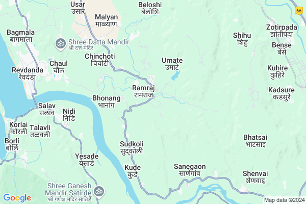
Ramraj
Ramraj Map
EDIT Map
Add Your House
 ..
..
Current Corona Virus Infected Patients Count in Raigad District
| City Name | District Name | Total Covid cases |
|---|
Locality Name :
Ramraj
( रामराज )
Taluka Name : Alibag
District : Raigad
State : Maharashtra
Region : Konkan
Division : Konkan
Language : Marathi and Hindi
Current Time 12:36 PM
Date: Friday , Apr 25,2025 (IST)
Time zone: IST (UTC+5:30)
Elevation / Altitude: 7 meters. Above Seal level
Telephone Code / Std Code: 02141
Assembly constituency : Alibag assembly constituency
Assembly MLA : Mahendra Hari Dalvi
Lok Sabha constituency : Raigad parliamentary constituency
Parliament MP : Tatkare Sunil Dattatray
Serpanch Name :
Pin Code : 402203
Post Office Name : Chaul
Alternate Village Name : Ramaraj
Commodities Prices : Roha Market / Mandi
Ramraj Live Weather
Temperature: 33.3 °C
broken clouds
Humidity: 35%
Wind : 1.63 mt/sec towards NW
StationName : "Revadanda"
observed on 2 Hours Back
Temperature: 33.3 °C
broken clouds
Humidity: 35%
Wind : 1.63 mt/sec towards NW
StationName : "Revadanda"
observed on 2 Hours Back
Ramraj Weather Forecast for Next 5 days
26-04-2025
26.0°C to 36.0°C
broken clouds, scattered clouds, clear sky
26.0°C to 36.0°C
broken clouds, scattered clouds, clear sky
27-04-2025
25.1°C to 36.6°C
scattered clouds, clear sky
25.1°C to 36.6°C
scattered clouds, clear sky
28-04-2025
24.7°C to 36.2°C
clear sky, few clouds
24.7°C to 36.2°C
clear sky, few clouds
29-04-2025
24.2°C to 34.8°C
clear sky
24.2°C to 34.8°C
clear sky
30-04-2025
24.6°C to 34.6°C
clear sky
24.6°C to 34.6°C
clear sky
Edit below overview about Ramraj
Edit below overview about Ramraj
OverView of Ramraj
The village Ramraj is having a beautifull landscape of river flowing adjoining tothe village and forming a loop with large number of farms and houses near it.Edit below overview about Ramraj
National Highways Reachable To Ramraj
Nationa High Way :NH48
Nationa High Way :NH166A
Nationa High Way :NH48
Nationa High Way :NH166A
Rivers Near Ramraj
Kasarsai :कासारसई
Pavana River :पवना
Kasarsai :कासारसई
Pavana River :पवना
About Ramraj
Ramraj is a Village in Alibag Taluka in Raigad District of Maharashtra State, India. It belongs to Konkan region . It belongs to Konkan Division . It is located 22 KM towards East from District head quarters Alibag. 19 KM from Alibag. 65 KM from State capital Mumbai
Ramraj Pin code is 402203 and postal head office is Chaul .
Chinchoti ( 5 KM ) , Mithekhar ( 6 KM ) , Sanegaon ( 6 KM ) , Dapoli ( 7 KM ) , Wavepotge ( 7 KM ) are the nearby Villages to Ramraj. Ramraj is surrounded by Alibag Taluka towards North , Raigad Taluka towards west , Murud Taluka towards South , Pen Taluka towards North .
Nandgaon , Pen , Uran , Lonavla are the near by Cities to Ramraj.
It is near to arabian sea. There is a chance of humidity in the weather.
Ramraj 2011 Census Details
Ramraj Local Language is Marathi. Ramraj Village Total population is 1636 and number of houses are 379. Female Population is 49.7%. Village literacy rate is 61.9% and the Female Literacy rate is 28.1%.
Population
| Census Parameter | Census Data |
| Total Population | 1636 |
| Total No of Houses | 379 |
| Female Population % | 49.7 % ( 813) |
| Total Literacy rate % | 61.9 % ( 1012) |
| Female Literacy rate | 28.1 % ( 459) |
| Scheduled Tribes Population % | 40.9 % ( 669) |
| Scheduled Caste Population % | 13.4 % ( 219) |
| Working Population % | 46.1 % |
| Child(0 -6) Population by 2011 | 183 |
| Girl Child(0 -6) Population % by 2011 | 46.4 % ( 85) |
Ramraj Census More Deatils.
Politics in Ramraj
PWPI , Nationalist Congress Party , PWP , NCP , SHS , INC are the major political parties in this area.Polling Stations /Booths near Ramraj
1)Malade 12)Ramraj 1
3)Rajpuri 3
4)Boraghar 2
5)Majgaon 3
HOW TO REACH Ramraj
By Rail
There is no railway station near to Ramraj in less than 10 km. are the Rail way stations reachable from near by towns.By Road
Alibag are the nearby by towns to Ramraj having road connectivity to RamrajColleges near Ramraj
J.b.sawant Edu.societys Tmc College
Address :
G.b.wader Collage Pali
Address :
S A K Juniour College Pangloli
Address :
Doshi Vakil Arts & G.c.u.b Sci & Com Collage - Goregaon
Address :
M.t.e.s. Doshi Vakil Arts & G.c.u.b Sci & Com Collage - Goregaon
Address :
Schools in Ramraj
R.z.p. Urdu School Ramraj
Address : ramraj , alibag , raigarh (maharashtra) , Maharashtra . PIN- 402203 , Post - Chaul
R.z.p. School Ramraj
Address : ramraj , alibag , raigarh (maharashtra) , Maharashtra . PIN- 402203 , Post - Chaul
Govt Health Centers near Ramraj
1) Cheher , UNSURVIED GAAVTHAN , CHEHER VILLAGE , NEAR CHEHER ANGANWADI2) Wave , Subcenter Wave , Wave Revdanda ,
3) Agrao , Subcenter Agrao , Agrao ,
Schools in Ramraj,Alibag
Electronic Shops in Ramraj,Alibag
Super Markets in Ramraj,Alibag
Local Parks in Ramraj,Alibag
Police Stations near Ramraj,Alibag
Governement Offices near Ramraj,Alibag
About Ramraj &
History
How to reach Ramraj
Tourist Places Near By Ramraj
Schools in Ramraj
Colleges in Ramraj
Temperature & weather of Ramraj
places in Ramraj
Ramraj photos
More Information
How to reach Ramraj
Tourist Places Near By Ramraj
Schools in Ramraj
Colleges in Ramraj
Temperature & weather of Ramraj
places in Ramraj
Ramraj photos
More Information
Village Talk
Post News or Events about this Village
Near Cities
Nandgaon 22 KM near
Pen 26 KM near
Uran 42 KM near
Lonavla 53 KM near
Nandgaon 22 KM near
Pen 26 KM near
Uran 42 KM near
Lonavla 53 KM near
Near By Taluks
Roha 18 KM near
Alibag 18 KM near
Raigad 20 KM near
Murud 22 KM near
Roha 18 KM near
Alibag 18 KM near
Raigad 20 KM near
Murud 22 KM near
Near By Air Ports
Chhatrapati Shivaji International Airport 70 KM near
Lohegaon Airport 107 KM near
Gandhinagar Airport 201 KM near
Kolhapur Airport 281 KM near
Chhatrapati Shivaji International Airport 70 KM near
Lohegaon Airport 107 KM near
Gandhinagar Airport 201 KM near
Kolhapur Airport 281 KM near
Near By Tourist Places
Nagaon Beach 14 KM near
Nagothane 14 KM near
Kashid 17 KM near
Raigad 20 KM near
Alibag 22 KM near
Nagaon Beach 14 KM near
Nagothane 14 KM near
Kashid 17 KM near
Raigad 20 KM near
Alibag 22 KM near
Near By Districts
Raigad 21 KM near
Mumbai 58 KM near
Thane 89 KM near
Pune 100 KM near
Raigad 21 KM near
Mumbai 58 KM near
Thane 89 KM near
Pune 100 KM near
Near By RailWay Station
Roha Rail Way Station 17 KM near
Mangaon Rail Way Station 48 KM near
Roha Rail Way Station 17 KM near
Mangaon Rail Way Station 48 KM near