| Home | City Bus | Maps | Villages | Cities | Rail | Tourist Places | School | College | Pin Codes | Corona Cases Count |
| Distance Calculator Bus Services IFSC Codes Trace Mobile Number Weather Search Place Trace IP Available Cash ATM/Banks Locate Polling Booth Report an Error contact People |
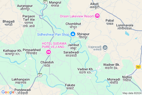
Jambut
Jambut Map
EDIT Map
Add Your House
 ..
..
Current Corona Virus Infected Patients Count in Pune District
| City Name | District Name | Total Covid cases |
|---|---|---|
| Pune District | Pune | 514 |
| PMC | Pune | 69 |
| Pimpri-Chinchwad | Pune | 49 |
| Pune | Pune | 40 |
| Pune Rural | Pune | 17 |
| PCMC | Pune | 8 |
| Parvati - Pune | Pune | 3 |
| Baramati | Pune | 1 |
| Hadapsar-Pune | Pune | 1 |
| Bhawani Peth Pune | Pune | 1 |
| Pune Dist | Pune | 1 |
| Limboni Nagar Pune | Pune | 1 |
| Hadapsar - Pune | Pune | 1 |
Locality Name :
Jambut
( जांबुत )
Taluka Name : Shirur
District : Pune
State : Maharashtra
Region : Desh or Paschim Maharashtra
Division : Pune
Language : Marathi and Hindi, Kannada, Marwari
Current Time 07:05 AM
Date: Saturday , Apr 26,2025 (IST)
Time zone: IST (UTC+5:30)
Elevation / Altitude: 186 meters. Above Seal level
Telephone Code / Std Code: 02138
Assembly constituency : Ambegaon assembly constituency
Assembly MLA : Dilip Dattatray Walse Patil
Lok Sabha constituency : Shirur parliamentary constituency
Parliament MP : Dr. Amol Ramsing Kolhe
Serpanch Name :
Pin Code : 410504
Post Office Name : Narayangaon
Commodities Prices : Parner Market / Mandi
Edit below overview about Jambut
Edit below overview about Jambut
OverView of Jambut
Jambut is a big village in shirur.It is known as BET BHAG, located on kukadi river. It is a village of temples.population of its is above 6000 . It is a midpoint between Narayangaon and shirur. mostly farmers taking crops of onion, sugarcane, corn, tomato, chillies ,gabbage etc, and selling near by markets Milk producion in Village is another important buisness(jod-dhanda), average each farmer is selling 30+ litre of milk daily.Edit below overview about Jambut
National Highways Reachable To Jambut
Nationa High Way :NH48
Nationa High Way :NH60
Nationa High Way :NH48
Nationa High Way :NH60
Rivers Near Jambut
Vel :वेळ
Kasarsai :कासारसई
Vel :वेळ
Kasarsai :कासारसई
About Jambut
Jambut is a Village in Shirur Taluka in Pune District of Maharashtra State, India. It belongs to Desh or Paschim Maharashtra region . It belongs to Pune Division . It is located 74 KM towards North from District head quarters Pune. 32 KM from Shirur. 165 KM from State capital Mumbai
Jambut Pin code is 410504 and postal head office is Narayangaon .
Chandoh ( 5 KM ) , Pimparkhed ( 7 KM ) , Lakhangaon ( 8 KM ) , Kathapur Kh. ( 9 KM ) , Pondewadi ( 11 KM ) are the nearby Villages to Jambut. Jambut is surrounded by Shirur Taluka towards South , Ambegaon Taluka towards west , Junnar Taluka towards west , Khed Taluka towards west .
Shirur , Manchar , Junnar , Ahmednagar are the near by Cities to Jambut.
Jambut 2011 Census Details
Jambut Local Language is Marathi. Jambut Village Total population is 3448 and number of houses are 722. Female Population is 49.4%. Village literacy rate is 70.1% and the Female Literacy rate is 31.3%.
Population
| Census Parameter | Census Data |
| Total Population | 3448 |
| Total No of Houses | 722 |
| Female Population % | 49.4 % ( 1704) |
| Total Literacy rate % | 70.1 % ( 2416) |
| Female Literacy rate | 31.3 % ( 1079) |
| Scheduled Tribes Population % | 0.9 % ( 31) |
| Scheduled Caste Population % | 6.1 % ( 212) |
| Working Population % | 56.5 % |
| Child(0 -6) Population by 2011 | 467 |
| Girl Child(0 -6) Population % by 2011 | 46.0 % ( 215) |
Jambut Census More Deatils.
Politics in Jambut
Nationalist Congress Party , NCP , SHS are the major political parties in this area.Polling Stations /Booths near Jambut
1)Jambhori2)Dabhademala
3)Kushire Bk.
4)Lakhangaon
5)Belsarwadi
HOW TO REACH Jambut
By Rail
There is no railway station near to Jambut in less than 10 km. Daund Junction Rail Way Station (near to Daund) , Pune Junction Rail Way Station (near to Pune) , Shivajinagar Rail Way Station (near to Pune) , Shrigonda Road Rail Way Station (near to Shrigonda) , Kashti Rail Way Station (near to Daund) are the Rail way stations reachable from near by towns.By Road
Shirur , Daund , Pune , Shrigonda are the nearby by towns to Jambut having road connectivity to JambutColleges near Jambut
Shree Datta Vidyalaya&junior Collage Pimperkhed
Address :
Sahebrao Shankarrao Dhamdhere Arts And Commerce College
Address : Talegaon Dhamdhere Tal- Shirur Dist-pune
Vidha Dham Junuor
Address :
Schools in Jambut
Adarsh New English School, Jambut
Address : Jambut
Govt Health Centers near Jambut
1) Jambhut , , ,2) Vadner Kh. , , ,
3) Phakate , , ,
Petrol Bunks in Jambut,Shirur
HP PETROL PUMP - PVP AUTO SERVICE
GAT NO.185/2 Jambut TAL Shirur Dist.; Pune; Maharashtra 410504; India
0.1 KM distance Detail
HP PETROL PUMP - OM SAI KRISHI SEVA KENDRA
GUT NO 715; AT Post Alkuti; Alkuti Belhe State Highway; TQ. Parner;; Maharashtra 414303; India
8.9 KM distance Detail
more ..
Colleges in Jambut,Shirur
Samarth Rural Educational institute
Bangarwadi; Belhe; Kalyan - Ahmednagar Highway; Pune; Maharashtra 412410; India
16.0 KM distance Detail
Samarth Group of Institutions Faculty of Management
Nagar- Kalyan highway; Bangarwadi; Belhe; Tal: Junnar; Dist: Pune; National Highway 222; Maharashtra 412410; India
16.8 KM distance Detail
more ..
Electronic Shops in Jambut,Shirur
श्री राम पाॅवर टिलर सर्विस
Kawathe - Jambut Road; Fakate; Maharashtra 410504; India
7.0 KM distance Detail
Local Parks in Jambut,Shirur
About Jambut &
History
How to reach Jambut
Tourist Places Near By Jambut
Schools in Jambut
Colleges in Jambut
Temperature & weather of Jambut
places in Jambut
Jambut photos
More Information
How to reach Jambut
Tourist Places Near By Jambut
Schools in Jambut
Colleges in Jambut
Temperature & weather of Jambut
places in Jambut
Jambut photos
More Information
Village Talk
Post News or Events about this Village
Near Cities
Shirur 29 KM near
Manchar 31 KM near
Junnar 45 KM near
Ahmednagar 65 KM near
Shirur 29 KM near
Manchar 31 KM near
Junnar 45 KM near
Ahmednagar 65 KM near
Near By Taluks
Parner 25 KM near
Shirur 30 KM near
Ambegaon 39 KM near
Junnar 43 KM near
Parner 25 KM near
Shirur 30 KM near
Ambegaon 39 KM near
Junnar 43 KM near
Near By Air Ports
Lohegaon Airport 61 KM near
Gandhinagar Airport 128 KM near
Chhatrapati Shivaji International Airport 156 KM near
Chikkalthana Airport 177 KM near
Lohegaon Airport 61 KM near
Gandhinagar Airport 128 KM near
Chhatrapati Shivaji International Airport 156 KM near
Chikkalthana Airport 177 KM near
Near By Tourist Places
Ozar 36 KM near
Junnar 45 KM near
Vadhu Tulapur 45 KM near
Ahmednagar 63 KM near
Pimpri-Chinchwad 66 KM near
Ozar 36 KM near
Junnar 45 KM near
Vadhu Tulapur 45 KM near
Ahmednagar 63 KM near
Pimpri-Chinchwad 66 KM near
Near By Districts
Ahmednagar 64 KM near
Pune 71 KM near
Nashik 131 KM near
Thane 154 KM near
Ahmednagar 64 KM near
Pune 71 KM near
Nashik 131 KM near
Thane 154 KM near
Near By RailWay Station
Ahmednagar Rail Way Station 62 KM near
Uruli Rail Way Station 63 KM near
Ahmednagar Rail Way Station 62 KM near
Uruli Rail Way Station 63 KM near