| Home | City Bus | Maps | Villages | Cities | Rail | Tourist Places | School | College | Pin Codes | Corona Cases Count |
| Distance Calculator Bus Services IFSC Codes Trace Mobile Number Weather Search Place Trace IP Available Cash ATM/Banks Locate Polling Booth Report an Error contact People |
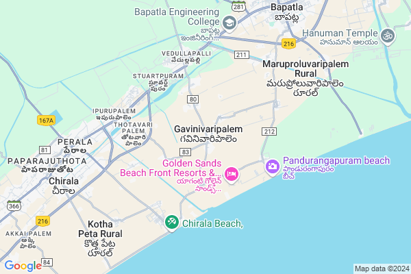
Tulasinagar
Tulasinagar Map
EDIT Map
Add Your House
 ..
..
Current Corona Virus Infected Patients Count in Prakasam District
| City Name | District Name | Total Covid cases |
|---|---|---|
| Prakasam District | Prakasam | 23 |
| Ongole | Prakasam | 19 |
| Chirala | Prakasam | 7 |
| Kunkalamarru,karamchedu | Prakasam | 2 |
| Konakalamitta Mandal | Prakasam | 1 |
| Kandukuru | Prakasam | 1 |
| Kunkala Marru | Prakasam | 1 |
| Markapur | Prakasam | 1 |
| Islamapet | Prakasam | 1 |
Locality Name :
Tulasinagar
( తులసినగర్ )
Mandal Name : Chirala
District : Prakasam
State : Andhra Pradesh
Region : Andhra
Language : Telugu
Current Time 05:42 AM
Date: Saturday , Apr 26,2025 (IST)
Time zone: IST (UTC+5:30)
Elevation / Altitude: 8 meters. Above Seal level
Telephone Code / Std Code: 08594
Assembly constituency : assembly constituency
Assembly MLA : KARANAM BALARAMA KRISHNA MURTHY
Lok Sabha constituency : parliamentary constituency
Parliament MP :
Serpanch Name :
Pin Code : 523166
Post Office Name : Ipurupalem
Main Village Name : Gavinivaripalem
Commodities Prices : Tenali Market / Mandi
Tulasinagar Live Weather
Temperature: 28.2 °C
scattered clouds
Humidity: 85%
Wind : 5.26 mt/sec towards S
StationName : "ChÄ«rÄ\u0081la"
observed on Now
Temperature: 28.2 °C
scattered clouds
Humidity: 85%
Wind : 5.26 mt/sec towards S
StationName : "ChÄ«rÄ\u0081la"
observed on Now
Tulasinagar Weather Forecast for Next 5 days
27-04-2025
28.1°C to 32.3°C
scattered clouds, broken clouds, few clouds, clear sky
28.1°C to 32.3°C
scattered clouds, broken clouds, few clouds, clear sky
28-04-2025
28.1°C to 32.3°C
light rain, broken clouds, scattered clouds, clear sky
28.1°C to 32.3°C
light rain, broken clouds, scattered clouds, clear sky
29-04-2025
28.4°C to 33.0°C
scattered clouds, few clouds, clear sky
28.4°C to 33.0°C
scattered clouds, few clouds, clear sky
30-04-2025
28.4°C to 33.0°C
clear sky
28.4°C to 33.0°C
clear sky
01-05-2025
28.6°C to 33.3°C
few clouds, clear sky, light rain, broken clouds
28.6°C to 33.3°C
few clouds, clear sky, light rain, broken clouds
National Highways Reachable To Tulasinagar
Nationa High Way :NH544D
Nationa High Way :NH216
Nationa High Way :NH544D
Nationa High Way :NH216
Rivers Near Tulasinagar
Nallamada Vagu
Nallamada Vagu
About Tulasinagar
Correct below Info and add more info about TulasinagarTulasinagar is a small Village/hamlet in Chirala Mandal in Prakasam District of Andhra Pradesh State, India. It comes under Gavinivaripalem Panchayath. It belongs to Andhra region . It is located 65 KM towards East from District head quarters Ongole. 7 KM from Chirala Nagar. 314 KM from State capital Hyderabad
Tulasinagar Pin code is 523166 and postal head office is Ipurupalem .
Tulasinagar is surrounded by Bapatla Mandal towards North , Vetapalem Mandal towards west , Karlapalem Mandal towards East , Karamchedu Mandal towards west .
Chirala , Bapatla , Ponnur , Chilakaluripet are the near by Cities to Tulasinagar.
This Place is in the border of the Prakasam District and Guntur District. Guntur District Bapatla is North towards this place . It is near to bay of bengal. There is a chance of humidity in the weather.
Demographics of Tulasinagar
Telugu is the Local Language here. Total population of Tulasinagar is 10987 .Males are 5583 and Females are 5,404 living in 2813 Houses. Total area of Tulasinagar is 2139 hectares.HOW TO REACH Tulasinagar
By Road
Chirala is the Nearest Town to Tulasinagar. Chirala is 10 km from Tulasinagar. Road connectivity is there from Chirala to Tulasinagar.By Rail
Stuartpuram Rail Way Station , Ipurupalem Rail Way Station are the very nearby railway stations to Tulasinagar. Also you can consider railway Stations from Near By town Chirala. Chirala Rail Way Station , Jandrapeta Rail Way Station are the railway Stations near to Chirala. You can reach from Chirala to Tulasinagar by road after .By Bus
Bapatla APSRTC Bus Station , Chirala APSRTC Bus Station , Karamchedu APSRTC Bus Station are the nearby by Bus Stations to Tulasinagar .APSRTC runs Number of busses from major cities to here.Colleges near Tulasinagar
Bharathi Degree College
Address :
Sri Vani Jr College Chirala
Address : Sri Vani Jr College Chirala
Vrs & Yrn College Of Engineering & Technology
Address : Vodarevu Road, Chirala - 523 157, Prakasam Dist.
Schools in Tulasinagar
Mpups Gavinivari Palem
Address : gavinivari palem , chirala , prakasam , Andhra Pradesh . PIN- 523166 , Post - Ipurupalem
Govt Health Centers near Tulasinagar
1) GAVINIVARIPALEM , PANCHAYATHI OFFICE , mainbazar gavinivaripalem , near panchayathi office2) Vedullapalli , GOVT , VRUKSHANAGAR , VEDULAPALLI CENTER
3) Vedullapalli , GOVT , VRUKSHANAGAR , VEDULAPALLI CENTER
Hospitals in Tulasinagar,Chirala
Dr Satyam Hospital
NH216; Vedullapalli; Bapatla West Rural; Andhra Pradesh 522317; India
4.6 KM distance Detail
bapuji Hospital
1-116;Gavinivaripalem Road; NH216; Vedullapalli; Chirala; Andhra Pradesh 522317; India
4.8 KM distance Detail
more ..
Petrol Bunks in Tulasinagar,Chirala
HP PETROL PUMP - SANTHOSH PETROLEUMS
HPC Dealers Vodarevu-chirala Road Vodarevu; Andhra Pradesh 523157; India
5.7 KM distance Detail
more ..
Colleges in Tulasinagar,Chirala
SKBNM ITI COLLEGE IPURUPALEM
Chirala Bypass Rd; Ipurupalem; Ipuru Palem Rural; Andhra Pradesh 523166; India
4.9 KM distance Detail
Sk Bhahmmanaidu Memorial Iti Epurupalem
Chirala; Ipuru Palem Rural; Andhra Pradesh 523166; India
5.0 KM distance Detail
VRS & YRN College of Engineering & Technology
Bypass Road; NTR Nagar; Chirala; Andhra Pradesh 523157; India
6.1 KM distance Detail
more ..
Schools in Tulasinagar,Chirala
Sri Sai Vidya Nikethan High School
Thotavari Palem; Chirala; Andhra Pradesh 523166; India
4.4 KM distance Detail
Vivek Vidyashram High School
NH216; Vedullapalli; Chirala; Andhra Pradesh 522317; India
4.6 KM distance Detail
Sa Aided Elementary School
NH216; Stuartpuram; Chirala; Andhra Pradesh 522317; India
4.6 KM distance Detail
Electronic Shops in Tulasinagar,Chirala
Sri Veera Brahmendra General Store
Chinabethapudi; Chirala; Andhra Pradesh 522317; India
5.2 KM distance Detail
S S Mobiles&services
Chirala;; Boyinavaripalem; Chirala; Andhra Pradesh 523166; India
5.4 KM distance Detail
KoteswaraRao TV Shop
Chirala; Ipuru Palem Rural; Andhra Pradesh 523166; India
5.5 KM distance Detail
Super Markets in Tulasinagar,Chirala
Chandra Kirana Shop
R T C Line; Kothapalem; Bapatla West Rural; Andhra Pradesh 522317; India
5.6 KM distance Detail
Royal Star Prabhu Teja
Ramanagar;; Cheetar Vihar; Ramanagar; Chirala; Andhra Pradesh 523157; India
6.8 KM distance Detail
Sri Srinivasa Killy & Cooldrinks
Vadarevu Rd; Perala; Chirala; Andhra Pradesh 523157; India
8.5 KM distance Detail
Local Parks in Tulasinagar,Chirala
Pragada Kotaiah Children Park
NH216; Ipurupalem; Chirala; Andhra Pradesh 523166; India
5.1 KM distance Detail
Police Stations near Tulasinagar,Chirala
Agriculture Committee Police Check Post
1-116;Gavinivaripalem Road; NH216; Vedullapalli; Bapatla West Rural; Andhra Pradesh 522317; India
4.6 KM distance Detail
Chirala Rural Police Station
NH216; Ipurupalem; Chirala; Andhra Pradesh 523166; India
4.9 KM distance Detail
Ipurupalem Police Station
NH216; Ipurupalem; Ipuru Palem Rural; Andhra Pradesh 523166; India
5.0 KM distance Detail
Governement Offices near Tulasinagar,Chirala
MeeSeva Center
Vedullapalli(L);Bapatla(M);Guntur(Dist); Vedullapalli; Andhra Pradesh 522317; India
4.8 KM distance Detail
Near LIC Office
opp; Railway Station Rd; Ipurupalem; Ipuru Palem Rural; Andhra Pradesh 523166; India
5.6 KM distance Detail
About Tulasinagar &
History
How to reach Tulasinagar
Tourist Places Near By Tulasinagar
Schools in Tulasinagar
Colleges in Tulasinagar
Temperature & weather of Tulasinagar
places in Tulasinagar
Tulasinagar photos
More Information
How to reach Tulasinagar
Tourist Places Near By Tulasinagar
Schools in Tulasinagar
Colleges in Tulasinagar
Temperature & weather of Tulasinagar
places in Tulasinagar
Tulasinagar photos
More Information
Village Talk
Post News or Events about this Village
Near Cities
Chirala 8 KM near
Bapatla 9 KM near
Ponnur 32 KM near
Chilakaluripet 44 KM near
Chirala 8 KM near
Bapatla 9 KM near
Ponnur 32 KM near
Chilakaluripet 44 KM near
Near By Taluks
Chirala 6 KM near
Bapatla 10 KM near
Vetapalem 13 KM near
Karlapalem 19 KM near
Chirala 6 KM near
Bapatla 10 KM near
Vetapalem 13 KM near
Karlapalem 19 KM near
Near By Air Ports
Vijayawada Airport 96 KM near
Rajahmundry Airport 229 KM near
Tirupati Airport 294 KM near
Rajiv Gandhi International Airport 295 KM near
Vijayawada Airport 96 KM near
Rajahmundry Airport 229 KM near
Tirupati Airport 294 KM near
Rajiv Gandhi International Airport 295 KM near
Near By Tourist Places
Guntur 58 KM near
Vijayawada 87 KM near
Amaravathi 90 KM near
Machelipatnam 94 KM near
Nagarjunakonda 128 KM near
Guntur 58 KM near
Vijayawada 87 KM near
Amaravathi 90 KM near
Machelipatnam 94 KM near
Nagarjunakonda 128 KM near
Near By Districts
Guntur 57 KM near
Prakasam 62 KM near
Krishna 93 KM near
West Godavari 135 KM near
Guntur 57 KM near
Prakasam 62 KM near
Krishna 93 KM near
West Godavari 135 KM near
Near By RailWay Station
Stuartpuram Rail Way Station 4.6 KM near
Ipurupalem Rail Way Station 5.7 KM near
Chirala Rail Way Station 9 KM near
Bapatla Rail Way Station 9 KM near
Stuartpuram Rail Way Station 4.6 KM near
Ipurupalem Rail Way Station 5.7 KM near
Chirala Rail Way Station 9 KM near
Bapatla Rail Way Station 9 KM near