| Home | City Bus | Maps | Villages | Cities | Rail | Tourist Places | School | College | Pin Codes | Corona Cases Count |
| Distance Calculator Bus Services IFSC Codes Trace Mobile Number Weather Search Place Trace IP Available Cash ATM/Banks Locate Polling Booth Report an Error contact People |
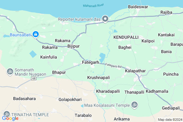
Fategarh Map
EDIT Map
Add Your House
 ..
..
Current Corona Virus Infected Patients Count in Nayagarh District
| City Name | District Name | Total Covid cases |
|---|
Locality Name :
Fategarh
( ଫତେଗଡ )
Tehsil Name : Bhapur
District : Nayagarh
State : Odisha
Language : Oriya and Hindi
Current Time 03:06 PM
Date: Wednesday , Feb 05,2025 (IST)
Time zone: IST (UTC+5:30)
Telephone Code / Std Code: 06756
Assembly constituency : Khandapada assembly constituency
Assembly MLA : anubhav patnaik
Lok Sabha constituency : Cuttack parliamentary constituency
Parliament MP : BHARTRUHARI MAHTAB
Serpanch Name :
Pin Code : 752063
Post Office Name : Bhapur (Nayagarh)
Commodities Prices : Banki Market / Mandi
Fategarh Live Weather
Temperature: 34.7 °C
overcast clouds
Humidity: 28%
Wind : 0.78 mt/sec towards NW
StationName : "Kantilo"
observed on 1 Hours Back
Temperature: 34.7 °C
overcast clouds
Humidity: 28%
Wind : 0.78 mt/sec towards NW
StationName : "Kantilo"
observed on 1 Hours Back
Fategarh Weather Forecast for Next 5 days
06-02-2025
22.6°C to 34.9°C
overcast clouds, scattered clouds
22.6°C to 34.9°C
overcast clouds, scattered clouds
07-02-2025
21.4°C to 35.2°C
overcast clouds, clear sky, few clouds
21.4°C to 35.2°C
overcast clouds, clear sky, few clouds
08-02-2025
21.4°C to 34.3°C
clear sky, scattered clouds, light rain
21.4°C to 34.3°C
clear sky, scattered clouds, light rain
09-02-2025
20.3°C to 34.2°C
clear sky
20.3°C to 34.2°C
clear sky
10-02-2025
19.3°C to 33.8°C
clear sky
19.3°C to 33.8°C
clear sky
National Highways Reachable To Fategarh
Nationa High Way :NH316
Nationa High Way :NH16
Nationa High Way :NH316
Nationa High Way :NH16
Rivers Near Fategarh
Rana
Mainshia
Rana
Mainshia
About Fategarh
Correct below Info and add more info about FategarhFategarh is a Village in Bhapur Tehsil in Nayagarh District of Odisha State, India. It is located 38 KM towards East from District head quarters Nayagarh. 5 KM from Bhapur. 62 KM from State capital Bhubaneswar
Fategarh Pin code is 752063 and postal head office is Bhapur (Nayagarh).
Sasana ( 3 KM ) , Salajharia ( 4 KM ) , Bhapur ( 4 KM ) , Karabara ( 5 KM ) , Kainfulia ( 5 KM ) are the nearby Villages to Fategarh. Fategarh is surrounded by Banki Tehsil towards East , Bolagarh Tehsil towards South , Badamba Tehsil towards North , Khandapara Tehsil towards west .
Khordha , Jatani , Dhenkanal , Bhubaneswar are the near by Cities to Fategarh.
Fategarh 2011 Census Details
Fategarh Local Language is Oriya. Fategarh Village Total population is 4611 and number of houses are 1098. Female Population is 48.2%. Village literacy rate is 71.1% and the Female Literacy rate is 30.5%.
Population
| Census Parameter | Census Data |
| Total Population | 4611 |
| Total No of Houses | 1098 |
| Female Population % | 48.2 % ( 2224) |
| Total Literacy rate % | 71.1 % ( 3278) |
| Female Literacy rate | 30.5 % ( 1405) |
| Scheduled Tribes Population % | 0.1 % ( 6) |
| Scheduled Caste Population % | 7.2 % ( 334) |
| Working Population % | 32.2 % |
| Child(0 -6) Population by 2011 | 483 |
| Girl Child(0 -6) Population % by 2011 | 46.2 % ( 223) |
Fategarh Census More Deatils.
Politics in Fategarh
BJD , is the major political party in this area.Polling Stations /Booths near Fategarh
1)Elapada U.g.m.e. School2)Fategarh M.e. School (r. No-1)
3)Fategarh Pry. School (r. No-1)
4)Patna Jamusahi Pry. School
5)Manibandha Kendupalli Pry. School
HOW TO REACH Fategarh
By Rail
There is no railway station near to Fategarh in less than 10 km.Colleges near Fategarh
Prahallada Mahavidyalaya, Padmabati
Address :
Bhapur Anchalika Mahavidyala Bhapur
Address : Jagannath Temple Road Bhapur
Schools in Fategarh
Fategarh Hs
Address : fategarh , bhapur , nayagarh , Sikkim . PIN- 752063 , Post - Bhapur (Nayagarh)
B.d.ups, Fatehgarh
Address : fategarh , bhapur , nayagarh , Sikkim . PIN- 752063 , Post - Bhapur (Nayagarh)
Govt Health Centers near Fategarh
1) Srirampur , Srirampur SubCentre , Srirampur , Srirampur2) Kodaberini , Koudaberini SubCentre , Koudaberini , Koudaberini
3) Kotasingh , Kotasinga SubCentre , Kotasinga , Kotasinga
Petrol Bunks in Fategarh,Bhapur
Kodabereni Petrol Station Chakadola Filling Station
Kodabereni; Odisha 752064; India
8.7 KM distance Detail
more ..
Electronic Shops in Fategarh,Bhapur
Tarini Electronics
Kalapather; Kalapathar - Banki Rd; Kalapathar; Odisha 754009; India
6.2 KM distance Detail
Governement Offices near Fategarh,Bhapur
New Gram Panchayat Office
Homeopathic Medical Road; Fategarh; Fategarh; Odisha 752063; India
0.4 KM distance Detail
MATHURA PRADHAN
At- Swapneswarpur; Po- Krushnapalli Patana; Kalapathar; Odisha 754009; India
6.2 KM distance Detail
About Fategarh &
History
How to reach Fategarh
Tourist Places Near By Fategarh
Schools in Fategarh
Colleges in Fategarh
Temperature & weather of Fategarh
places in Fategarh
Fategarh photos
More Information
How to reach Fategarh
Tourist Places Near By Fategarh
Schools in Fategarh
Colleges in Fategarh
Temperature & weather of Fategarh
places in Fategarh
Fategarh photos
More Information
Village Talk
Post News or Events about this Village
Near Cities
Khordha 37 KM near
Jatani 46 KM near
Dhenkanal 55 KM near
Bhubaneswar 56 KM near
Khordha 37 KM near
Jatani 46 KM near
Dhenkanal 55 KM near
Bhubaneswar 56 KM near
Near By Taluks
Bhapur 5 KM near
Banki 13 KM near
Bolagarh 15 KM near
Badamba 16 KM near
Bhapur 5 KM near
Banki 13 KM near
Bolagarh 15 KM near
Badamba 16 KM near
Near By Air Ports
Bhubaneswar Airport 57 KM near
Ranchi Airport 375 KM near
Vishakhapatnam Airport 404 KM near
Raipur Airport 432 KM near
Bhubaneswar Airport 57 KM near
Ranchi Airport 375 KM near
Vishakhapatnam Airport 404 KM near
Raipur Airport 432 KM near
Near By Tourist Places
Bhubaneswar 57 KM near
Nandan Kanan National Park 57 KM near
Chilika 62 KM near
Cuttack 67 KM near
Puri 84 KM near
Bhubaneswar 57 KM near
Nandan Kanan National Park 57 KM near
Chilika 62 KM near
Cuttack 67 KM near
Puri 84 KM near
Near By Districts
Nayagarh 36 KM near
Dhenkanal 53 KM near
Khordha 56 KM near
Cuttack 68 KM near
Nayagarh 36 KM near
Dhenkanal 53 KM near
Khordha 56 KM near
Cuttack 68 KM near
Near By RailWay Station
Nirakarpur Rail Way Station 45 KM near
Khurda Road Junction Rail Way Station 47 KM near
Nirakarpur Rail Way Station 45 KM near
Khurda Road Junction Rail Way Station 47 KM near