| Home | City Bus | Maps | Villages | Cities | Rail | Tourist Places | School | College | Pin Codes | Corona Cases Count |
| Distance Calculator Bus Services IFSC Codes Trace Mobile Number Weather Search Place Trace IP Available Cash ATM/Banks Locate Polling Booth Report an Error contact People |
 ..
..
Current Corona Virus Infected Patients Count in Nalgonda District
| City Name | District Name | Total Covid cases |
|---|---|---|
| Suryapet District | Suryapet | 72 |
| Nalgonda District | Nalgonda | 15 |
Mandal Name : Penpahad
District : Nalgonda
State : Telangana
Region : Telangana
Language : Telugu and Urdu
Current Time 04:28 AM
Date: Friday , Nov 01,2024 (IST)
Time zone: IST (UTC+5:30)
Elevation / Altitude: 152 meters. Above Seal level
Telephone Code / Std Code: 08684
Assembly constituency : Suryapet assembly constituency
Assembly MLA : Guntakandla Jagadish Reddy
Lok Sabha constituency : Nalgonda parliamentary constituency
Parliament MP : UTTAM KUMAR REDDY NALAMADA
Serpanch Name :
Pin Code : 508233
Post Office Name : Munagala
Alternate Village Name : Mukundapuram
Commodities Prices : Suryapeta Market / Mandi
Temperature: 22.5 °C
few clouds
Humidity: 94%
Wind : 1.57 mt/sec towards SE
StationName : "SuriÄ\u0081pet"
observed on 13 Mins Back
22.4°C to 30.0°C
few clouds, clear sky, light rain, scattered clouds
22.8°C to 30.0°C
clear sky, light rain, moderate rain
22.5°C to 29.9°C
light rain, scattered clouds, clear sky
22.2°C to 30.5°C
clear sky, scattered clouds, few clouds
OverView of Mukunda Poor
Mukunda name is derived from mukunda family that is surname this is i heard from senior citizen in my village,now this is modified chatlamukundapuram all are called this name,this village somany years under in chedalla, this village formed at 150 yers before so many familly's are came to different villag's and formed small village. according to in my village senior citizens some peoples are started constructed for crows house from chedalla then started came to differnt villages form a village.
Culturely this village is bhagavatham,scipt, singers,dancers, specific event is kabadi ,youth clubs are conducted so many culturel programes in this village main occupation cultivation some peoples are depending on dailly works
Edit below overview about Mukunda Poor
Nationa High Way :NH365BB
Nationa High Way :Old NH9
Musi River
About Mukunda Poor
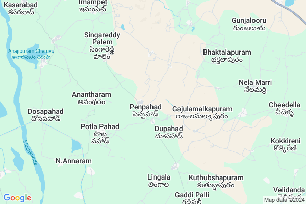
Mukunda Poor is a Village in Penpahad Mandal in Nalgonda District of Telangana State, India. It belongs to Telangana region . As part Telangana Districts re-organisation , Mukunda Poor Village Penpahad Mandal re organised from Nalgonda District to Suryapet district. It is located 53 KM towards East from District head quarters Nalgonda.
Mukunda Poor Pin code is 508233 and postal head office is Munagala .
Mukunda Poor is surrounded by Chivvemla Mandal towards North , Munagala Mandal towards East , Garide Pally Mandal towards South , Suryapet Mandal towards North .
Suryapet , Miryalaguda , Kodad , Jaggaiahpet are the near by Cities to Mukunda Poor.
Demographics of Mukunda Poor
Telugu is the Local Language here.Politics in Mukunda Poor
TDP , TRS , INC are the major political parties in this area.Polling Stations /Booths near Mukunda Poor
1)Patharla Pahad2)Penpahad
3)Lingala
4)Macharam
5)Isthalapuram
HOW TO REACH Mukunda Poor
By Rail
There is no railway station near to Mukunda Poor in less than 10 km. are the Rail way stations reachable from near by towns.By Road
Suryapet are the nearby by towns to Mukunda Poor having road connectivity to Mukunda PoorColleges near Mukunda Poor
R J R Memorial Jr College, PenpahadSchools near Mukunda Poor
Kgbv PenpahadGovt Health Centers near Mukunda Poor
1) Primary Health Centre, Penpahad , Public , Main Road , Opp High School2) SubCentre, Penpahad , Public , Main Road , Opp High School
3) SubCentre, Guddimalkapur , 3-8 / , Main Road , Beside GP
Sub Villages in Mukunda Poor
Hospitals in Mukunda Poor,Penpahad
jyothi multi speciality hospital
telangana talli statue lakshmi vilas bank; Nalgonda; Telangana 508213; India
5.8 KM distance Detail
more ..
Petrol Bunks in Mukunda Poor,Penpahad
SHIVA PETROLEUM COMPANY
Lingamanthula Swamy Temple Durajpally; Lingamanthula Swamy Temple Road; Suryapet; Telangana 508213; India
10.8 KM distance Detail
more ..
Colleges in Mukunda Poor,Penpahad
Sidhartha Physical Education College
Janareddy Nagar; Telangana 508213; India
7.0 KM distance Detail
K.J.R College Of Pharmacy
Dosapahad Village; Penpahad Mandal; Suryapet; Telangana; India
9.5 KM distance Detail
PRATISHTA INSTITUTE OF PHARMACEUTICAL SCIENCES
Durajpally; Chivemla; Suryapet; Telangana 508214; India
10.2 KM distance Detail
Kamakshi College of Engineering and Technology
Durajpally;Chivvemal; Telangana 508214; India
10.3 KM distance Detail
more ..
Schools in Mukunda Poor,Penpahad
Sri. Rangineni Jagannadha Rao Cooperative Junior College
Main Road; Penpahad (Village and Mandal). Nalgonda District; Telangana 508213; India; India
0.9 KM distance Detail
Mandal Praja Parishad High School
Penpahad (Village); Penpahad (Mandal); Nalgonda; Telangana; India
1.0 KM distance Detail
Oruganti Veera Raagavulu Memorial Primary School
Macharam; Telangana 508213; India
1.7 KM distance Detail
Police Stations near Mukunda Poor,Penpahad
Police Station Suryapet
Barlapenta Bazaar; Suryapet; Telangana 508213; India
16.8 KM distance Detail
Suryapet Rural Police Station
Thallagadda; Suryapet; Telangana 508213; India
18.3 KM distance Detail
How to reach Mukunda Poor
Tourist Places Near By Mukunda Poor
Schools in Mukunda Poor
Colleges in Mukunda Poor
Temperature & weather of Mukunda Poor
places in Mukunda Poor
Mukunda Poor photos
More Information
Village Talk
Post News or Events about this Village
Suryapet 15 KM near
Miryalaguda 23 KM near
Kodad 32 KM near
Jaggaiahpet 51 KM near
Penpahad 0 KM near
Chivvemla 11 KM near
Munagala 14 KM near
Garide Pally 15 KM near
Vijayawada Airport 145 KM near
Rajiv Gandhi International Airport 152 KM near
Rajahmundry Airport 253 KM near
Nanded Airport 388 KM near
Nagarjunakonda 44 KM near
Khammam 61 KM near
Nagarjunsagar 72 KM near
Amaravathi 99 KM near
Warangal 120 KM near
Nalgonda 51 KM near
Khammam 61 KM near
Warangal 119 KM near
Guntur 126 KM near
Miryalaguda Rail Way Station 28 KM near
Vishnupuram Rail Way Station 40 KM near
