| Home | City Bus | Maps | Villages | Cities | Rail | Tourist Places | School | College | Pin Codes | Corona Cases Count |
| Distance Calculator Bus Services IFSC Codes Trace Mobile Number Weather Search Place Trace IP Available Cash ATM/Banks Locate Polling Booth Report an Error contact People |
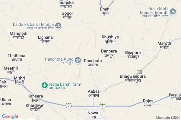
Panchota Map
EDIT Map
Add Your House
 ..
..
Current Corona Virus Infected Patients Count in Nagaur District
| City Name | District Name | Total Covid cases |
|---|---|---|
| Nagaur District | Nagaur | 113 |
Locality Name :
Panchota
( पांचोता )
Tehsil Name : Kuchaman
District : Nagaur
State : Rajasthan
Division : Ajmer
Language : Marwari and Hindi, English, Urdu Rajasthani
Current Time 06:57 PM
Date: Tuesday , Apr 29,2025 (IST)
Time zone: IST (UTC+5:30)
Elevation / Altitude: 404 meters. Above Seal level
Telephone Code / Std Code: 01586
Assembly constituency : Parbatsar assembly constituency
Assembly MLA : Ramniwas Gawriya
Lok Sabha constituency : Nagaur parliamentary constituency
Parliament MP : HANUMAN BENIWAL
Serpanch Name :
Pin Code : 341509
Post Office Name : Nawacity Lsg
Commodities Prices : Kishan Renwal(Sambhar) Market / Mandi
Rivers Near Panchota
Mendha
Mendha
About Panchota
Correct below Info and add more info about PanchotaPanchota is a Village in Kuchaman Tehsil in Nagaur District of Rajasthan State, India. It belongs to Ajmer Division . It is located 147 KM towards East from District head quarters Nagaur. 12 KM from Kuchaman. 96 KM from State capital Jaipur
Panchota Pin code is 341509 and postal head office is Nawacity Lsg .
Bhooni ( 6 KM ) , Lichana ( 6 KM ) , Maharajpura ( 8 KM ) , Indokha ( 9 KM ) , Maroth ( 9 KM ) are the nearby Villages to Panchota. Panchota is surrounded by Danta Ramgarh Tehsil towards North , Sambhar Tehsil towards East , Makrana Tehsil towards west , Dudu Tehsil towards South .
Makrana , Sambhar , Phulera , Losal are the near by Cities to Panchota.
Panchota 2011 Census Details
Panchota Local Language is Marwari. Panchota Village Total population is 3411 and number of houses are 587. Female Population is 49.6%. Village literacy rate is 55.9% and the Female Literacy rate is 21.8%.
Population
| Census Parameter | Census Data |
| Total Population | 3411 |
| Total No of Houses | 587 |
| Female Population % | 49.6 % ( 1691) |
| Total Literacy rate % | 55.9 % ( 1907) |
| Female Literacy rate | 21.8 % ( 745) |
| Scheduled Tribes Population % | 5.7 % ( 193) |
| Scheduled Caste Population % | 18.7 % ( 639) |
| Working Population % | 43.9 % |
| Child(0 -6) Population by 2011 | 474 |
| Girl Child(0 -6) Population % by 2011 | 52.3 % ( 248) |
Panchota Census More Deatils.
Politics in Panchota
Rashtriya Loktantrik Party , BJP , INC are the major political parties in this area.Polling Stations /Booths near Panchota
1)Govt. Secondary School Khardia2)Govt. Secondry School East Block Rasal
3)Govt. Secondry School Nenia
4)Govt. Upper Primary School Kalkalan Ki Dhani
5)Govt. Secondary School West Block Kinsariya
HOW TO REACH Panchota
By Rail
Nawa City Rail Way Station , Naya Kharadia Rail Way Station are the very nearby railway stations to Panchota.Colleges near Panchota
Tagore Engg. College
Address :
Jupiter Institute Of Technology And Management
Address : S
Nalanda Girls College Maroth
Address :
Marwar Health Care Society , Ayurved Nurse/comp. College
Address : Marwar Health Care Society , Ayurved Nurse/comp. C
Schools in Panchota
Anand Public School
Address : panchota , kuchaman , nagaur , Rajasthan . PIN- 341509 , Post - Nawacity Lsg
Gups Kalali Nadi
Address : panchota , kuchaman , nagaur , Rajasthan . PIN- 341509 , Post - Nawacity Lsg
Gss Panchota
Address : panchota , kuchaman , nagaur , Rajasthan . PIN- 341509 , Post - Nawacity Lsg
Govt Health Centers near Panchota
1) DANPURA , SUB HEALTH CENTER DANPURA , DANPURA , DANPURA2) Nawan City , COMMUNITY HEALTH CENTER NAWA CITY , Nawan City , Nawan City
3) MAROTH , COMMUNITY HEALTH CENTER MAROTH , NALLA BAZAR , MAROTH
Petrol Bunks in Panchota,Kuchaman
petrol Pump Lichana
341533; RD Complex; U-3; Unnamed Rd; Sector 3; Avas Vikas Colony; Sikandra; Agra; Rajasthan 282004; India
6.2 KM distance Detail
more ..
Colleges in Panchota,Kuchaman
B.R.Kabra Mahila Shikshak Prashikshan Mahavidhyalaya
Station Road; Near Reliance Petrol Pump ; Ajmer Road; Kuchaman City; Nagaur; Nagaur; Rajasthan 341508; India
16.6 KM distance Detail
Balaji B.ED College
Asanpura; Didwana Road; Kuchamancity; Nagaur; Rajasthan 341508; India
16.6 KM distance Detail
B R Khokhar Coaching Centre
Padampura Road; Kuchaman City; Rajasthan 341508; India
17.5 KM distance Detail
more ..
Super Markets in Panchota,Kuchaman
Mahalaxmi Trading Company
Prajapati Colony; Kuchaman City; Rajasthan 341508; India
18.2 KM distance Detail
Police Stations near Panchota,Kuchaman
Police Station Kuchaman City
RJ SH 2; Kuchaman City; Rajasthan 341508; India
18.4 KM distance Detail
About Panchota &
History
How to reach Panchota
Tourist Places Near By Panchota
Schools in Panchota
Colleges in Panchota
Temperature & weather of Panchota
places in Panchota
Panchota photos
More Information
How to reach Panchota
Tourist Places Near By Panchota
Schools in Panchota
Colleges in Panchota
Temperature & weather of Panchota
places in Panchota
Panchota photos
More Information
Village Talk
Post News or Events about this Village
Near Cities
Makrana 30 KM near
Sambhar 30 KM near
Phulera 36 KM near
Losal 40 KM near
Makrana 30 KM near
Sambhar 30 KM near
Phulera 36 KM near
Losal 40 KM near
Near By Taluks
Kuchaman 11 KM near
Danta Ramgarh 40 KM near
Sambhar 41 KM near
Makrana 45 KM near
Kuchaman 11 KM near
Danta Ramgarh 40 KM near
Sambhar 41 KM near
Makrana 45 KM near
Near By Air Ports
Sanganeer Airport 94 KM near
Jodhpur Airport 239 KM near
Indira Gandhi International Airport 295 KM near
Surat Gujarat Airport 300 KM near
Sanganeer Airport 94 KM near
Jodhpur Airport 239 KM near
Indira Gandhi International Airport 295 KM near
Surat Gujarat Airport 300 KM near
Near By Tourist Places
Kuchaman 17 KM near
Kishangarh 64 KM near
Sikar 69 KM near
Ajmer 87 KM near
Pushkar 88 KM near
Kuchaman 17 KM near
Kishangarh 64 KM near
Sikar 69 KM near
Ajmer 87 KM near
Pushkar 88 KM near
Near By Districts
Sikar 67 KM near
Ajmer 86 KM near
Jaipur 91 KM near
Jhunjhunu 137 KM near
Sikar 67 KM near
Ajmer 86 KM near
Jaipur 91 KM near
Jhunjhunu 137 KM near
Near By RailWay Station
Nawa City Rail Way Station 6.6 KM near
Naya Kharadia Rail Way Station 9.2 KM near
Kuchaman City Rail Way Station 16 KM near
Nawa City Rail Way Station 6.6 KM near
Naya Kharadia Rail Way Station 9.2 KM near
Kuchaman City Rail Way Station 16 KM near