| Home | City Bus | Maps | Villages | Cities | Rail | Tourist Places | School | College | Pin Codes | Corona Cases Count |
| Distance Calculator Bus Services IFSC Codes Trace Mobile Number Weather Search Place Trace IP Available Cash ATM/Banks Locate Polling Booth Report an Error contact People |
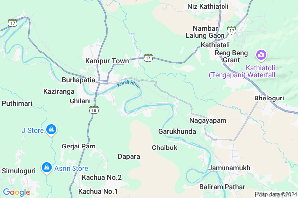
Barpathar
Barpathar Map
EDIT Map
Add Your House
 ..
..
Current Corona Virus Infected Patients Count in Nagaon District
| City Name | District Name | Total Covid cases |
|---|
Locality Name :
Barpathar
( बर्पाथर )
Tehsil Name : Kathiatoli
District : Nagaon
State : Assam
Language : Assamese and Bengali
Current Time 08:46 AM
Date: Wednesday , Apr 30,2025 (IST)
Time zone: IST (UTC+5:30)
Elevation / Altitude: 70 meters. Above Seal level
Telephone Code / Std Code: 03672
Assembly constituency : Barhampur assembly constituency
Assembly MLA : Jitu Goswami
Lok Sabha constituency : Nawgong parliamentary constituency
Parliament MP : Pradyut Bordoloi
Serpanch Name :
Pin Code : 782450
Post Office Name : Baithalangsho
Commodities Prices : Jowai Market / Mandi
Barpathar Live Weather
Temperature: 21.7 °C
broken clouds
Humidity: 74%
Wind : 2.78 mt/sec towards SE
StationName : "RahÄ\u0081"
observed on 2 Hours Back
Temperature: 21.7 °C
broken clouds
Humidity: 74%
Wind : 2.78 mt/sec towards SE
StationName : "RahÄ\u0081"
observed on 2 Hours Back
Barpathar Weather Forecast for Next 5 days
01-05-2025
22.1°C to 34.3°C
broken clouds, overcast clouds, light rain
22.1°C to 34.3°C
broken clouds, overcast clouds, light rain
02-05-2025
21.8°C to 37.9°C
broken clouds, overcast clouds, light rain
21.8°C to 37.9°C
broken clouds, overcast clouds, light rain
03-05-2025
22.1°C to 37.3°C
broken clouds, overcast clouds, few clouds, scattered clouds, light rain
22.1°C to 37.3°C
broken clouds, overcast clouds, few clouds, scattered clouds, light rain
04-05-2025
22.5°C to 34.4°C
light rain, scattered clouds, broken clouds
22.5°C to 34.4°C
light rain, scattered clouds, broken clouds
05-05-2025
23.3°C to 34.6°C
light rain, broken clouds, scattered clouds
23.3°C to 34.6°C
light rain, broken clouds, scattered clouds
National Highways Reachable To Barpathar
Nationa High Way :NH306
Nationa High Way :NH6
Nationa High Way :NH306
Nationa High Way :NH6
Rivers Near Barpathar
Um Loti
Dalalma River
Um Loti
Dalalma River
About Barpathar
Correct below Info and add more info about BarpatharBarpathar is a Village in Kathiatoli Tehsil in Nagaon District of Assam State, India. It is located 26 KM towards South from District head quarters Nagaon. 110 KM from State capital Dispur
Barpathar Pin code is 782450 and postal head office is Baithalangsho .
Barpathar is surrounded by Pakhimoria Tehsil towards west , Raha Tehsil towards west , Binakandi Tehsil towards East , Khagarijan Tehsil towards North .
Hojai , Nagaon , Lanka , Marigaon are the near by Cities to Barpathar.
Borpatia 2011 Census Details
Barpathar Local Language is Assamese. Borpatia Village Total population is and number of houses are . Female Population is -1.0%. Village literacy rate is -1.0% and the Female Literacy rate is -1.0%.
Population
| Census Parameter | Census Data |
| Total Population | |
| Total No of Houses | |
| Female Population % | -1.0 % ( ) |
| Total Literacy rate % | -1.0 % ( ) |
| Female Literacy rate | -1.0 % ( ) |
| Scheduled Tribes Population % | -1.0 % ( ) |
| Scheduled Caste Population % | -1.0 % ( ) |
| Working Population % | -1.0 % |
| Child(0 -6) Population by 2011 | |
| Girl Child(0 -6) Population % by 2011 | -1.0 % ( ) |
Borpatia Census More Deatils.
Politics in Barpathar
83.87% , Indian National Congress , BJP , AGP , 66833 , INC are the major political parties in this area.Polling Stations /Booths near Barpathar
1)Maj Pathari Thiatangani Primary School2)Majarati L.p. School (east Pt.)
3)Kampur Adarsha High School
4)Kampur Girls High School
5)Kampur Higher Secondary & M.p. School
HOW TO REACH Barpathar
By Rail
Kampur Rail Way Station , Jamunamukh Rail Way Station are the very nearby railway stations to Barpathar.Colleges near Barpathar
Gurukul Junior College, Kampur
Address : Kampur
Lutumari Parizat Rastrabasha Mahabidyalaya
Address : Lutumari Bazar
Schools in Barpathar
Maj Barpathar Kacharigaon Lp
Address : barpathar , kathiatoli , nagaon , Assam . PIN- 782450 , Post - Baithalangsho
Barpathar Lp
Address : barpathar , kathiatoli , nagaon , Assam . PIN- 782450 , Post - Baithalangsho
Govt Health Centers near Barpathar
1) Kachua Model Hospital , Kachua Model Hospital , Kachua Bazar Road , Kachua Bazar2) Sitalmari SC , Sitalmari SC , Baithalangsu Road , Near Field
3) Bagalajan SD , Bagalajan SD , Bagalajan , Raha to Kampur road, Near Bagalajan LP School
Petrol Bunks in Barpathar,Kathiatoli
Kampur Oil Pump (Assam Oil)
Kampur Petrol Pump; Kampur Bazar Road; Kampur Town; Assam 782426; India
3.7 KM distance Detail
Reliance Petrol Pump; Kathiatoli; Nagaon
Pachim Nambar Lalung Gaon; Assam 782427; India
5.8 KM distance Detail
more ..
Colleges in Barpathar,Kathiatoli
KAMPUR GYANDEEP Jr.COLLEGE(Sciencee & Arts)
Near Pujabari Mandir; Kampur Town; Assam 782426; India
3.8 KM distance Detail
more ..
Schools in Barpathar,Kathiatoli
Girls' School UP(ছোৱালী স্কুল উ.প্ৰা.)
Dakhin Chang Chaki; Assam 782426; India
3.4 KM distance Detail
Sankardev Bidya Niketon; Kathiatoli
Kathiatoli Rd; Bhalbhalia Gaon; Assam 782426; India
3.5 KM distance Detail
Police Stations near Barpathar,Kathiatoli
Kathiatoli Police Patrol Post
Nagaon - Lumding Road; Kathiatali; Assam 782427; India
7.6 KM distance Detail
Governement Offices near Barpathar,Kathiatoli
Bharat Sanchar Nigam Limited
Uttar Chang Chaki; Nagaon; SH-17; Kathiatoli Road; Nagaon; Nagaon; Assam 782426; India
3.8 KM distance Detail
About Barpathar &
History
How to reach Barpathar
Tourist Places Near By Barpathar
Schools in Barpathar
Colleges in Barpathar
Temperature & weather of Barpathar
places in Barpathar
Barpathar photos
More Information
How to reach Barpathar
Tourist Places Near By Barpathar
Schools in Barpathar
Colleges in Barpathar
Temperature & weather of Barpathar
places in Barpathar
Barpathar photos
More Information
Village Talk
Post News or Events about this Village
Near Cities
Hojai 24 KM near
Nagaon 25 KM near
Lanka 41 KM near
Marigaon 41 KM near
Hojai 24 KM near
Nagaon 25 KM near
Lanka 41 KM near
Marigaon 41 KM near
Near By Taluks
Kathiatoli 0 KM near
Pakhimoria 4 KM near
Raha 17 KM near
Binakandi 21 KM near
Kathiatoli 0 KM near
Pakhimoria 4 KM near
Raha 17 KM near
Binakandi 21 KM near
Near By Air Ports
Salonibari Airport 70 KM near
Shillong Airport 115 KM near
Borjhar Airport 123 KM near
Dimapur Airport 125 KM near
Salonibari Airport 70 KM near
Shillong Airport 115 KM near
Borjhar Airport 123 KM near
Dimapur Airport 125 KM near
Near By Tourist Places
Nagaon 24 KM near
Golaghat 39 KM near
Orang National Park 63 KM near
Tezpur 63 KM near
Mangaldai 81 KM near
Nagaon 24 KM near
Golaghat 39 KM near
Orang National Park 63 KM near
Tezpur 63 KM near
Mangaldai 81 KM near
Near By Districts
Nagaon 25 KM near
Marigaon 41 KM near
Darrang 81 KM near
Sonitpur 86 KM near
Nagaon 25 KM near
Marigaon 41 KM near
Darrang 81 KM near
Sonitpur 86 KM near
Near By RailWay Station
Kampur Rail Way Station 4.0 KM near
Jamunamukh Rail Way Station 8.1 KM near
Chaparmukh Junction Rail Way Station 20 KM near
Kampur Rail Way Station 4.0 KM near
Jamunamukh Rail Way Station 8.1 KM near
Chaparmukh Junction Rail Way Station 20 KM near