| Home | City Bus | Maps | Villages | Cities | Rail | Tourist Places | School | College | Pin Codes | Corona Cases Count |
| Distance Calculator Bus Services IFSC Codes Trace Mobile Number Weather Search Place Trace IP Available Cash ATM/Banks Locate Polling Booth Report an Error contact People |
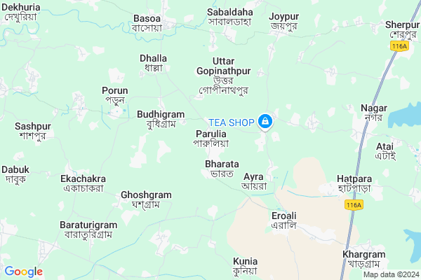
Parulia
Parulia Map
EDIT Map
Add Your House
 ..
..
Current Corona Virus Infected Patients Count in Murshidabad District
| City Name | District Name | Total Covid cases |
|---|
Locality Name :
Parulia
( পারুলিয়া )
Block Name : Khargram
District : Murshidabad
State : West Bengal
Division : Presidency
Language : Bengali and English
Current Time 07:40 AM
Date: Saturday , Apr 26,2025 (IST)
Time zone: IST (UTC+5:30)
Elevation / Altitude: 27 meters. Above Seal level
Telephone Code / Std Code: 03484
Assembly constituency : Khargram assembly constituency
Assembly MLA : Ashis Marjit
Lok Sabha constituency : Jangipur parliamentary constituency
Parliament MP : KHALILUR RAHAMAN
Serpanch Name :
Pin Code : 742147
Post Office Name : Khargram
Commodities Prices : Rampurhat Market / Mandi
Parulia Live Weather
Temperature: 26.2 °C
clear sky
Humidity: 86%
Wind : 4.97 mt/sec towards S
StationName : "Rampur Hat"
observed on 2 Hours Back
Temperature: 26.2 °C
clear sky
Humidity: 86%
Wind : 4.97 mt/sec towards S
StationName : "Rampur Hat"
observed on 2 Hours Back
Parulia Weather Forecast for Next 5 days
27-04-2025
26.2°C to 43.0°C
clear sky
26.2°C to 43.0°C
clear sky
28-04-2025
25.5°C to 40.7°C
scattered clouds, overcast clouds, light rain, broken clouds
25.5°C to 40.7°C
scattered clouds, overcast clouds, light rain, broken clouds
29-04-2025
24.3°C to 31.8°C
light rain, broken clouds, clear sky, scattered clouds
24.3°C to 31.8°C
light rain, broken clouds, clear sky, scattered clouds
30-04-2025
23.0°C to 35.1°C
broken clouds, scattered clouds, few clouds, light rain, moderate rain, overcast clouds
23.0°C to 35.1°C
broken clouds, scattered clouds, few clouds, light rain, moderate rain, overcast clouds
National Highways Reachable To Parulia
Nationa High Way :NH114
Nationa High Way :NH114
Rivers Near Parulia
Brahmani
Dwaraka
Brahmani
Dwaraka
About Parulia
Correct below Info and add more info about ParuliaParulia is a Village in Khargram Block in Murshidabad District of West Bengal State, India. It belongs to Presidency Division . It is located 42 KM towards west from District head quarters Baharampur. 8 KM from Khargram. 203 KM from State capital Kolkata
Parulia Pin code is 742147 and postal head office is Khargram .
Eroali ( 6 KM ) , Sabaldaha ( 7 KM ) , Kirtipur ( 8 KM ) , Padamkandi ( 9 KM ) , Khargram ( 11 KM ) are the nearby Villages to Parulia. Parulia is surrounded by Mayureswar-I Block towards west , Rampurhat-Ii Block towards North , Burwan Block towards South , Mayureswar-Ii Block towards South .
Rampurhat , Sainthia , Baharampur , Murshidabad are the near by Cities to Parulia.
Parulia 2011 Census Details
Parulia Local Language is Bengali. Parulia Village Total population is 4400 and number of houses are 1091. Female Population is 49.0%. Village literacy rate is 55.5% and the Female Literacy rate is 24.8%.
Population
| Census Parameter | Census Data |
| Total Population | 4400 |
| Total No of Houses | 1091 |
| Female Population % | 49.0 % ( 2154) |
| Total Literacy rate % | 55.5 % ( 2443) |
| Female Literacy rate | 24.8 % ( 1093) |
| Scheduled Tribes Population % | 6.2 % ( 272) |
| Scheduled Caste Population % | 43.6 % ( 1919) |
| Working Population % | 36.8 % |
| Child(0 -6) Population by 2011 | 534 |
| Girl Child(0 -6) Population % by 2011 | 49.6 % ( 265) |
Parulia Census More Deatils.
Politics in Parulia
CPM , All India Trinamool Congress , INC are the major political parties in this area.Polling Stations /Booths near Parulia
1)Parulia (haricharan) High School2)Parulia Dakshin Primary School
3)Jatarpur Primary School Room-2
4)Parbatipur Junior Basic School
5)Bhalkundi Primary School Room-2
HOW TO REACH Parulia
By Rail
There is no railway station near to Parulia in less than 10 km.Colleges near Parulia
Jatindra Rajendra Mahavidyalaya
Address :
Krishnath College
Address :
Paradise Institute Of Technology
Address : Vill. - Narasinghapur, P.o. - Sagarpara, P.s. - Jalangi, Dist. - Murshidabad, Pin - 742306
Sewnarayan Rameswar Fatepuria College
Address :
Charaborty Tutorial & Study Centre
Address :
Schools in Parulia
Parulia Haricharan High School ( H.s.)
Address : VILL- PARULIA, PO- PARULIA, PS + BLOCK- KHARGRAM, DIST- MURSHIDABAD
Govt Health Centers near Parulia
1) Parulia PHC SC , Parulia SC , Bayen Para ,2) Ishanpur SC , Ishanpur SC , Kanaidangapara , Podda BT High School
3) Kirtipur HQ SC , Kirtipur SC , kirtipur Hindu Para , Shib Tample
Petrol Bunks in Parulia,Khargram
Saheb Petrol Pump & Saheb Transport
SH 7; Sherpur; West Bengal 742159; India
12.8 KM distance Detail
more ..
Electronic Shops in Parulia,Khargram
Biswanath All D T H Seles&service
Bus Stand Rd; Purulia; West Bengal 723101; India
0.3 KM distance Detail
Police Stations near Parulia,Khargram
Khargram Police Station
Baadshahi Road; Near Post Office; Khargram; West Bengal 742147; India
10.7 KM distance Detail
About Parulia &
History
How to reach Parulia
Tourist Places Near By Parulia
Schools in Parulia
Colleges in Parulia
Temperature & weather of Parulia
places in Parulia
Parulia photos
More Information
How to reach Parulia
Tourist Places Near By Parulia
Schools in Parulia
Colleges in Parulia
Temperature & weather of Parulia
places in Parulia
Parulia photos
More Information
Village Talk
Post News or Events about this Village
Near Cities
Rampurhat 18 KM near
Sainthia 37 KM near
Baharampur 38 KM near
Murshidabad 44 KM near
Rampurhat 18 KM near
Sainthia 37 KM near
Baharampur 38 KM near
Murshidabad 44 KM near
Near By Taluks
Khargram 8 KM near
Mayureswar-I 13 KM near
Rampurhat-Ii 15 KM near
Burwan 18 KM near
Khargram 8 KM near
Mayureswar-I 13 KM near
Rampurhat-Ii 15 KM near
Burwan 18 KM near
Near By Air Ports
Netaji Subhas Chandra Bose Airport 188 KM near
Ranchi Airport 309 KM near
Bagdogra Airport 327 KM near
Rupsi Airport 342 KM near
Netaji Subhas Chandra Bose Airport 188 KM near
Ranchi Airport 309 KM near
Bagdogra Airport 327 KM near
Rupsi Airport 342 KM near
Near By Tourist Places
Murshidabad 42 KM near
Suri 47 KM near
Santiniketan 56 KM near
Pakur 69 KM near
Dumka 78 KM near
Murshidabad 42 KM near
Suri 47 KM near
Santiniketan 56 KM near
Pakur 69 KM near
Dumka 78 KM near
Near By Districts
Murshidabad 40 KM near
Birbhum 48 KM near
Pakur 69 KM near
Dumka 78 KM near
Murshidabad 40 KM near
Birbhum 48 KM near
Pakur 69 KM near
Dumka 78 KM near
Near By RailWay Station
Rampurhat Junction Rail Way Station 18 KM near
Nalhati Junction Rail Way Station 27 KM near
Rampurhat Junction Rail Way Station 18 KM near
Nalhati Junction Rail Way Station 27 KM near