| Home | City Bus | Maps | Villages | Cities | Rail | Tourist Places | School | College | Pin Codes | Corona Cases Count |
| Distance Calculator Bus Services IFSC Codes Trace Mobile Number Weather Search Place Trace IP Available Cash ATM/Banks Locate Polling Booth Report an Error contact People |
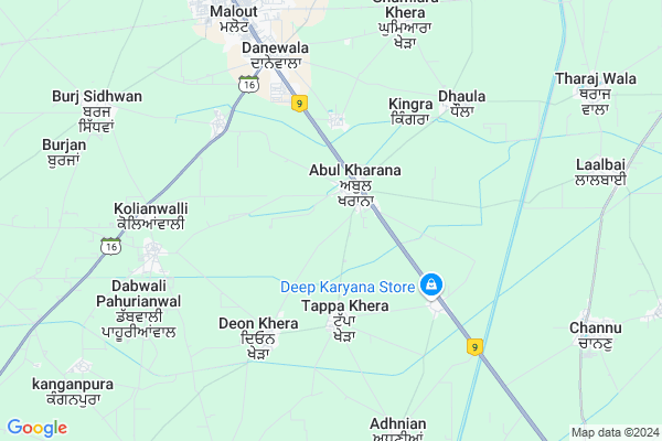
Abul Khurana Map
EDIT Map
Add Your House
 ..
..
Current Corona Virus Infected Patients Count in Muktsar District
| City Name | District Name | Total Covid cases |
|---|
Locality Name :
Abul Khurana
( ਅਬੁਲ ਖੁਰਾਣਾ )
Tehsil Name : Lambi
District : Muktsar
State : Punjab
Language : Punjabi (gurmukhi)
Current Time 11:39 AM
Date: Sunday , Apr 27,2025 (IST)
Time zone: IST (UTC+5:30)
Elevation / Altitude: 195 meters. Above Seal level
Telephone Code / Std Code: 01637
Assembly constituency : Malout assembly constituency
Assembly MLA : Dr. Baljit Kaur
Lok Sabha constituency : Ferozpur parliamentary constituency
Parliament MP : SUKHBIR SINGH BADAL
Serpanch Name :
Pin Code : 152114
Post Office Name : Tappa Khera
Commodities Prices : Malout Market / Mandi
Abul Khurana Live Weather
Temperature: 39.3 °C
clear sky
Humidity: 6%
Wind : 1.44 mt/sec towards SE
StationName : "Malaut"
observed on 1 Hours Back
Temperature: 39.3 °C
clear sky
Humidity: 6%
Wind : 1.44 mt/sec towards SE
StationName : "Malaut"
observed on 1 Hours Back
Abul Khurana Weather Forecast for Next 5 days
28-04-2025
29.0°C to 42.0°C
clear sky
29.0°C to 42.0°C
clear sky
29-04-2025
27.0°C to 43.8°C
clear sky
27.0°C to 43.8°C
clear sky
30-04-2025
29.5°C to 45.5°C
clear sky
29.5°C to 45.5°C
clear sky
01-05-2025
29.9°C to 46.6°C
clear sky, scattered clouds
29.9°C to 46.6°C
clear sky, scattered clouds
02-05-2025
32.6°C to 45.5°C
broken clouds, overcast clouds, few clouds, scattered clouds
32.6°C to 45.5°C
broken clouds, overcast clouds, few clouds, scattered clouds
Edit below overview about Abul Khurana
Edit below overview about Abul Khurana
OverView of Abul Khurana
Vinay Pratap Singh Brar the Sardar Bahadur of Abulkhurana whoes forefathers took over this village from chaudhary clan and dislocated them since then the family is the foremost .This family is the direct disendents of the earnest while Bhatti rajputs who once"s ruled the desert city or citadel of Jaislmer .Edit below overview about Abul Khurana
National Highways Reachable To Abul Khurana
Nationa High Way :NH62
Nationa High Way :NH354E
Nationa High Way :NH62
Nationa High Way :NH354E
About Abul Khurana
Abul Khurana is a Village in Lambi Tehsil in Muktsar District of Punjab State, India. It is located 45 KM towards South from District head quarters Sri Muktsar Sahib. 12 KM from Lambi. 264 KM from State capital Chandigarh
Abul Khurana Pin code is 152114 and postal head office is Tappa Khera .
Tappa Khera ( 2 KM ) , Rathrian ( 4 KM ) , Mahuanna ( 4 KM ) , Chhapian Wali ( 5 KM ) , Dane Wala ( 5 KM ) are the nearby Villages to Abul Khurana. Abul Khurana is surrounded by Malout Tehsil towards North , Gidderbaha Tehsil towards North , Sangat Tehsil towards East , Abohar Tehsil towards west .
Malout , Giddarbaha , Mukatsar , Mandi Dabwali are the near by Cities to Abul Khurana.
Demographics of Abul Khurana
Punjabi (gurmukhi) is the Local Language here.Politics in Abul Khurana
SAD , CPI , INC are the major political parties in this area.Polling Stations /Booths near Abul Khurana
1)Ghagga2)Khunde Halal
3)Eena Kherha
4)Fakarsar
5)Fakarsar
HOW TO REACH Abul Khurana
By Rail
Malout Rail Way Station , Faqar Sar Rail Way Station are the very nearby railway stations to Abul Khurana.Colleges near Abul Khurana
State Institute Of Nursing & Para Medical Sciences
Address : State Institute Of Nursing & Para Medical Sciences
Dasmesh Girls College Of Education
Address : Badal, Block Lambi, Muktsar-152113 Punjab
Schools in Abul Khurana
A.r.mem. Pb. Sch. Abul Khurana
Address : abul khurana , lambi , muktsar , Punjab . PIN- 152114 , Post - Tappa Khera
Gsss Abul Khurana(g)
Address : abul khurana , lambi , muktsar , Punjab . PIN- 152114 , Post - Tappa Khera
Gsss Abul Khurana(b)
Address : abul khurana , lambi , muktsar , Punjab . PIN- 152114 , Post - Tappa Khera
Govt Health Centers near Abul Khurana
1) Abul Khurana , SC Abul khurana , ,2) Deon Khera , SC Deon Khera , ,
3) Rathrian , , ,
Sub Villages in Abul Khurana
Petrol Bunks in Abul Khurana,Lambi
Pure Fill Abul Khurana; Indian Oil Petrol Pump
petrol pump NH-09; Abulkhurana;; Malout; Punjab 152107; India
2.4 KM distance Detail
Reliance Petroleum
RELIANCE PETRO MARKETING PVT. LIMITED; DEFENCE ROAD NEAR DANAWALA CHOWK; MALOUT; Malout; Punjab 152107; India
5.5 KM distance Detail
more ..
Colleges in Abul Khurana,Lambi
Guru Gobind Singh College of Education
Rathrian Road; Rathrian; Punjab 152114; India
3.6 KM distance Detail
more ..
Super Markets in Abul Khurana,Lambi
Bala Ji Softy And Ice Cream corner
dashmesh colony Near G.T.B school; Malout; Punjab; India
8.2 KM distance Detail
About Abul Khurana &
History
How to reach Abul Khurana
Tourist Places Near By Abul Khurana
Schools in Abul Khurana
Colleges in Abul Khurana
Temperature & weather of Abul Khurana
places in Abul Khurana
Abul Khurana photos
More Information
How to reach Abul Khurana
Tourist Places Near By Abul Khurana
Schools in Abul Khurana
Colleges in Abul Khurana
Temperature & weather of Abul Khurana
places in Abul Khurana
Abul Khurana photos
More Information
Village Talk
Post News or Events about this Village
Near Cities
Malout 6 KM near
Giddarbaha 17 KM near
Mukatsar 21 KM near
Mandi Dabwali 28 KM near
Malout 6 KM near
Giddarbaha 17 KM near
Mukatsar 21 KM near
Mandi Dabwali 28 KM near
Near By Taluks
Lambi 12 KM near
Malout 17 KM near
Gidderbaha 25 KM near
Sangat 26 KM near
Lambi 12 KM near
Malout 17 KM near
Gidderbaha 25 KM near
Sangat 26 KM near
Near By Air Ports
Surat Gujarat Airport 122 KM near
Ludhiana Airport 171 KM near
Raja Sansi Airport 198 KM near
Chandigarh Airport 252 KM near
Surat Gujarat Airport 122 KM near
Ludhiana Airport 171 KM near
Raja Sansi Airport 198 KM near
Chandigarh Airport 252 KM near
Near By Tourist Places
Muktsar 21 KM near
Bathinda 46 KM near
Faridkot 71 KM near
Shri Ganganagar 74 KM near
Mansa 94 KM near
Muktsar 21 KM near
Bathinda 46 KM near
Faridkot 71 KM near
Shri Ganganagar 74 KM near
Mansa 94 KM near
Near By Districts
Muktsar 42 KM near
Bathinda 45 KM near
Hanumangarh 69 KM near
Faridkot 70 KM near
Muktsar 42 KM near
Bathinda 45 KM near
Hanumangarh 69 KM near
Faridkot 70 KM near
Near By RailWay Station
Malout Rail Way Station 8.1 KM near
Faqar Sar Rail Way Station 9.1 KM near
Giddarbaha Rail Way Station 16 KM near
Malout Rail Way Station 8.1 KM near
Faqar Sar Rail Way Station 9.1 KM near
Giddarbaha Rail Way Station 16 KM near