| Home | City Bus | Maps | Villages | Cities | Rail | Tourist Places | School | College | Pin Codes | Corona Cases Count |
| Distance Calculator Bus Services IFSC Codes Trace Mobile Number Weather Search Place Trace IP Available Cash ATM/Banks Locate Polling Booth Report an Error contact People |
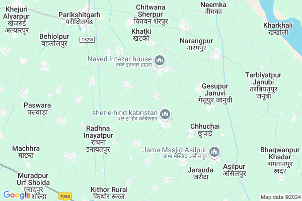
Atalpur
Atalpur Map
EDIT Map
Add Your House
 ..
..
Current Corona Virus Infected Patients Count in Meerut District
| City Name | District Name | Total Covid cases |
|---|---|---|
| Meerut District | Meerut | 89 |
Locality Name :
Atalpur
( अटलपुर )
Block Name : Parikshitgarh
District : Meerut
State : Uttar Pradesh
Division : Meerut
Language : Hindi and Urdu
Current Time 05:47 PM
Date: Saturday , Apr 26,2025 (IST)
Time zone: IST (UTC+5:30)
Elevation / Altitude: 229 meters. Above Seal level
Telephone Code / Std Code: 01233
Assembly constituency : Hastinapur assembly constituency
Assembly MLA : Dinesh
Lok Sabha constituency : Bijnor parliamentary constituency
Parliament MP : MALOOK NAGAR
Serpanch Name :
Pin Code : 250104
Post Office Name : Kithore
Commodities Prices : Parikshitgarh Market / Mandi
Atalpur Live Weather
Temperature: 42.3 °C
scattered clouds
Humidity: 4%
Wind : 3.21 mt/sec towards NW
StationName : "Kithor"
observed on 2 Hours Back
Temperature: 42.3 °C
scattered clouds
Humidity: 4%
Wind : 3.21 mt/sec towards NW
StationName : "Kithor"
observed on 2 Hours Back
Atalpur Weather Forecast for Next 5 days
27-04-2025
30.3°C to 41.8°C
scattered clouds, broken clouds, overcast clouds
30.3°C to 41.8°C
scattered clouds, broken clouds, overcast clouds
28-04-2025
29.2°C to 42.9°C
overcast clouds, broken clouds, few clouds, scattered clouds
29.2°C to 42.9°C
overcast clouds, broken clouds, few clouds, scattered clouds
29-04-2025
28.0°C to 43.8°C
broken clouds, clear sky, few clouds
28.0°C to 43.8°C
broken clouds, clear sky, few clouds
30-04-2025
26.9°C to 42.2°C
few clouds, clear sky
26.9°C to 42.2°C
few clouds, clear sky
01-05-2025
28.0°C to 40.7°C
clear sky, scattered clouds, overcast clouds
28.0°C to 40.7°C
clear sky, scattered clouds, overcast clouds
National Highways Reachable To Atalpur
Nationa High Way :NH334
Nationa High Way :NH334B
Nationa High Way :NH334
Nationa High Way :NH334B
Rivers Near Atalpur
Kali Nadi
Hindon River
Kali Nadi
Hindon River
About Atalpur
Correct below Info and add more info about AtalpurAtalpur is a Village in Parikshitgarh Block in Meerut District of Uttar Pradesh State, India. It belongs to Meerut Division . It is located 33 KM towards East from District head quarters Meerut. 5 KM from Parichhatgarh Dehat. 435 KM from State capital Lucknow
Atalpur Pin code is 250104 and postal head office is Kithore .
Laliyana ( 2 KM ) , Bondra ( 2 KM ) , Ahmadpuri Urf Amanpuri ( 2 KM ) , Amarsinghpur ( 3 KM ) , Alamgirpur Badhla ( 3 KM ) are the nearby Villages to Atalpur. Atalpur is surrounded by Machra Block towards west , Garh Mukteshwar Block towards South , Rajpura Block towards west , Simbhawali Block towards South .
Hastinapur , Meerut , Hapur , Pilkhuwa are the near by Cities to Atalpur.
Atalpur 2011 Census Details
Atalpur Local Language is Hindi. Atalpur Village Total population is 1608 and number of houses are 276. Female Population is 44.6%. Village literacy rate is 66.4% and the Female Literacy rate is 24.4%.
Population
| Census Parameter | Census Data |
| Total Population | 1608 |
| Total No of Houses | 276 |
| Female Population % | 44.6 % ( 717) |
| Total Literacy rate % | 66.4 % ( 1068) |
| Female Literacy rate | 24.4 % ( 392) |
| Scheduled Tribes Population % | 0.0 % ( 0) |
| Scheduled Caste Population % | 10.2 % ( 164) |
| Working Population % | 29.1 % |
| Child(0 -6) Population by 2011 | 213 |
| Girl Child(0 -6) Population % by 2011 | 39.9 % ( 85) |
Atalpur Census More Deatils.
Politics in Atalpur
PECP , BJP , JD , SP , BSP , INC are the major political parties in this area.Polling Stations /Booths near Atalpur
1)Ucch Prathmik Vidyalayapurab Chhucchai2)Prathmik Vidyalaya Room No.-1 Asilpur
3)Prathmik Vidyalaya Room No.-1 Khatki
4)Prathmik Vidyalaya Room No.-2 Khatki
5)Islamiyan Modern Junior High School Makhdoompur Road Mawana Room No.-2
HOW TO REACH Atalpur
By Rail
There is no railway station near to Atalpur in less than 10 km.Colleges near Atalpur
Dhara Iti, Dhara Public School
Address :
Schools near Atalpur
Jn H.s Dayal Pur
Address : dayalpur , parikshit garh , meerut , Uttar Pradesh . PIN- 250406 , Post - Parikshatgarh
Jn.h.s.rajpur
Address : dayalpur , parikshit garh , meerut , Uttar Pradesh . PIN- 250406 , Post - Parikshatgarh
Jamiatul Salehat Ikla .r.pur
Address : ikla rasulpur , parikshit garh , meerut , Uttar Pradesh . PIN- 250401 , Post - Mawana Tehsil
Jhs Chitmana Sherpur
Address : chitmana , parikshit garh , meerut , Uttar Pradesh . PIN- 250401 , Post - Mawana Tehsil
Govt Health Centers near Atalpur
1) Nawal , , KILA PARIKSHIT GARH , UTTAR PRADESH2) Kithore , , ,
3) Kithore , , ,
Schools in Atalpur,Parikshitgarh
Electronic Shops in Atalpur,Parikshitgarh
Super Markets in Atalpur,Parikshitgarh
Local Parks in Atalpur,Parikshitgarh
Police Stations near Atalpur,Parikshitgarh
Governement Offices near Atalpur,Parikshitgarh
About Atalpur &
History
How to reach Atalpur
Tourist Places Near By Atalpur
Schools in Atalpur
Colleges in Atalpur
Temperature & weather of Atalpur
places in Atalpur
Atalpur photos
More Information
How to reach Atalpur
Tourist Places Near By Atalpur
Schools in Atalpur
Colleges in Atalpur
Temperature & weather of Atalpur
places in Atalpur
Atalpur photos
More Information
Village Talk
Post News or Events about this Village
Near Cities
Hastinapur 27 KM near
Meerut 30 KM near
Hapur 34 KM near
Pilkhuwa 44 KM near
Hastinapur 27 KM near
Meerut 30 KM near
Hapur 34 KM near
Pilkhuwa 44 KM near
Near By Taluks
Parikshitgarh 5 KM near
Machra 9 KM near
Garh Mukteshwar 19 KM near
Rajpura 20 KM near
Parikshitgarh 5 KM near
Machra 9 KM near
Garh Mukteshwar 19 KM near
Rajpura 20 KM near
Near By Air Ports
Muzaffarnagar Airport 71 KM near
Indira Gandhi International Airport 106 KM near
Pantnagar Airport 163 KM near
Dehra Dun Airport 172 KM near
Muzaffarnagar Airport 71 KM near
Indira Gandhi International Airport 106 KM near
Pantnagar Airport 163 KM near
Dehra Dun Airport 172 KM near
Near By Tourist Places
Hastinapur 28 KM near
Meerut 31 KM near
Bulandshahr 67 KM near
Noida 84 KM near
Moradabad 88 KM near
Hastinapur 28 KM near
Meerut 31 KM near
Bulandshahr 67 KM near
Noida 84 KM near
Moradabad 88 KM near
Near By Districts
Meerut 31 KM near
Jyotiba Phule Nagar 53 KM near
Bijnor 57 KM near
Bulandshahr 67 KM near
Meerut 31 KM near
Jyotiba Phule Nagar 53 KM near
Bijnor 57 KM near
Bulandshahr 67 KM near
Near By RailWay Station
Garhmuktesar Rail Way Station 21 KM near
Gajraula Junction Rail Way Station 31 KM near
Garhmuktesar Rail Way Station 21 KM near
Gajraula Junction Rail Way Station 31 KM near