| Home | City Bus | Maps | Villages | Cities | Rail | Tourist Places | School | College | Pin Codes | Corona Cases Count |
| Distance Calculator Bus Services IFSC Codes Trace Mobile Number Weather Search Place Trace IP Available Cash ATM/Banks Locate Polling Booth Report an Error contact People |
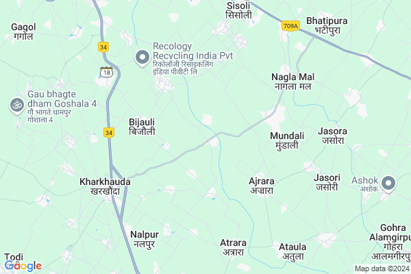
Kaul
Kaul Map
EDIT Map
Add Your House
 ..
..
Current Corona Virus Infected Patients Count in Meerut District
| City Name | District Name | Total Covid cases |
|---|---|---|
| Meerut District | Meerut | 89 |
Locality Name :
Kaul
( कॉल )
Block Name : Kharkhoda
District : Meerut
State : Uttar Pradesh
Division : Meerut
Language : Hindi and Urdu
Current Time 10:21 AM
Date: Wednesday , Apr 30,2025 (IST)
Time zone: IST (UTC+5:30)
Elevation / Altitude: 219 meters. Above Seal level
Telephone Code / Std Code: 0122
Assembly constituency : Kithore assembly constituency
Assembly MLA : Shahid Manzoor
Lok Sabha constituency : Meerut parliamentary constituency
Parliament MP : RAJENDRA AGARWAL
Serpanch Name :
Pin Code : 250401
Post Office Name : Mawana Tehsil
Commodities Prices : Meerut Market / Mandi
Kaul Live Weather
Temperature: 33.8 °C
clear sky
Humidity: 25%
Wind : 4.38 mt/sec towards SE
StationName : "Kharkhauda"
observed on Now
Temperature: 33.8 °C
clear sky
Humidity: 25%
Wind : 4.38 mt/sec towards SE
StationName : "Kharkhauda"
observed on Now
Kaul Weather Forecast for Next 5 days
01-05-2025
29.8°C to 38.1°C
clear sky, scattered clouds
29.8°C to 38.1°C
clear sky, scattered clouds
02-05-2025
27.8°C to 41.0°C
broken clouds, overcast clouds, clear sky, few clouds, scattered clouds
27.8°C to 41.0°C
broken clouds, overcast clouds, clear sky, few clouds, scattered clouds
03-05-2025
28.0°C to 41.5°C
overcast clouds, scattered clouds, few clouds, clear sky
28.0°C to 41.5°C
overcast clouds, scattered clouds, few clouds, clear sky
04-05-2025
25.9°C to 41.9°C
scattered clouds, light rain, few clouds, broken clouds, overcast clouds
25.9°C to 41.9°C
scattered clouds, light rain, few clouds, broken clouds, overcast clouds
05-05-2025
26.4°C to 40.6°C
overcast clouds, broken clouds
26.4°C to 40.6°C
overcast clouds, broken clouds
Edit below overview about Kaul
Edit below overview about Kaul
OverView of Kaul
Tyagi dominated village People main occupation is farming This village is located near the kali nadhiEdit below overview about Kaul
National Highways Reachable To Kaul
Nationa High Way :NH709B
Nationa High Way :NH34;NH334
Nationa High Way :NH709B
Nationa High Way :NH34;NH334
Rivers Near Kaul
Bagad River
Bagad River
Bagad River
Bagad River
About Kaul
Kaul is a Village in Kharkhoda Block in Meerut District of Uttar Pradesh State, India. It belongs to Meerut Division . It is located 19 KM towards South from District head quarters Meerut. 3 KM from Kharkhoda. 447 KM from State capital Lucknow
Kaul Pin code is 250401 and postal head office is Mawana Tehsil .
Nityanandpur ( 1 KM ) , Kharkhari ( 2 KM ) , Badholi ( 3 KM ) , Chhattri ( 3 KM ) , Nagla Kaboolpur ( 3 KM ) are the nearby Villages to Kaul. Kaul is surrounded by Machra Block towards East , Rajpura Block towards North , Meerut Block towards North , Bhojpur Block towards west .
Hapur , Meerut , Pilkhuwa , Modinagar are the near by Cities to Kaul.
This Place is in the border of the Meerut District and Ghaziabad District. Ghaziabad District Bhojpur is west towards this place .
Kaul 2011 Census Details
Kaul Local Language is Hindi. Kaul Village Total population is 2937 and number of houses are 429. Female Population is 47.2%. Village literacy rate is 58.9% and the Female Literacy rate is 23.5%.
Population
| Census Parameter | Census Data |
| Total Population | 2937 |
| Total No of Houses | 429 |
| Female Population % | 47.2 % ( 1385) |
| Total Literacy rate % | 58.9 % ( 1731) |
| Female Literacy rate | 23.5 % ( 690) |
| Scheduled Tribes Population % | 0.0 % ( 0) |
| Scheduled Caste Population % | 17.3 % ( 508) |
| Working Population % | 31.3 % |
| Child(0 -6) Population by 2011 | 498 |
| Girl Child(0 -6) Population % by 2011 | 45.0 % ( 224) |
Kaul Census More Deatils.
Politics in Kaul
BJP , SP , BSP , BKKGP are the major political parties in this area.Polling Stations /Booths near Kaul
1)Ucchtar Prathmik Vidhalya Room No;1 Amhera Adipur2)Unch Prathmik Vidhyalya Room No -2 Kaul
3)Prathmik Vidhalya Bijoli
4)Shree Shyamlal Junior High School West Atrara
5)Ucch Prathmik Vidhalya Gulzar Husain Room No-1 Ajrara
HOW TO REACH Kaul
By Rail
Kharkhauda Rail Way Station , Chandsara Halt Rail Way Station are the very nearby railway stations to Kaul.Colleges near Kaul
Mejar Asharam Tyagi Inter College
Address :
Dav Degree College
Address :
Schools in Kaul
D.k. Public School
Address : kaul , kharkhoda , meerut , Uttar Pradesh . PIN- 250406 , Post - Parikshatgarh
Jn H.s Kaul
Address : kaul , kharkhoda , meerut , Uttar Pradesh . PIN- 245206 , Post - Kharkhuda
Govt Health Centers near Kaul
1) BIJOLI , , ,2) PHAPHUNDA , , 204-A , UTTAR PRADESH
3) AJRADA 2nd , , ,
Schools in Kaul,Kharkhoda
Electronic Shops in Kaul,Kharkhoda
Super Markets in Kaul,Kharkhoda
Local Parks in Kaul,Kharkhoda
Police Stations near Kaul,Kharkhoda
Governement Offices near Kaul,Kharkhoda
About Kaul &
History
How to reach Kaul
Tourist Places Near By Kaul
Schools in Kaul
Colleges in Kaul
Temperature & weather of Kaul
places in Kaul
Kaul photos
More Information
How to reach Kaul
Tourist Places Near By Kaul
Schools in Kaul
Colleges in Kaul
Temperature & weather of Kaul
places in Kaul
Kaul photos
More Information
Village Talk
Post News or Events about this Village
Near Cities
Hapur 17 KM near
Meerut 18 KM near
Pilkhuwa 23 KM near
Modinagar 24 KM near
Hapur 17 KM near
Meerut 18 KM near
Pilkhuwa 23 KM near
Modinagar 24 KM near
Near By Taluks
Kharkhoda 3 KM near
Machra 13 KM near
Rajpura 15 KM near
Meerut 16 KM near
Kharkhoda 3 KM near
Machra 13 KM near
Rajpura 15 KM near
Meerut 16 KM near
Near By Air Ports
Muzaffarnagar Airport 72 KM near
Indira Gandhi International Airport 84 KM near
Dehra Dun Airport 183 KM near
Pantnagar Airport 184 KM near
Muzaffarnagar Airport 72 KM near
Indira Gandhi International Airport 84 KM near
Dehra Dun Airport 183 KM near
Pantnagar Airport 184 KM near
Near By Tourist Places
Meerut 18 KM near
Hastinapur 43 KM near
Bulandshahr 57 KM near
Noida 62 KM near
Delhi 67 KM near
Meerut 18 KM near
Hastinapur 43 KM near
Bulandshahr 57 KM near
Noida 62 KM near
Delhi 67 KM near
Near By Districts
Meerut 18 KM near
Ghaziabad 46 KM near
Bulandshahr 57 KM near
East Delhi 59 KM near
Meerut 18 KM near
Ghaziabad 46 KM near
Bulandshahr 57 KM near
East Delhi 59 KM near
Near By RailWay Station
Kharkhauda Rail Way Station 6.5 KM near
Chandsara Halt Rail Way Station 8.2 KM near
Hapur Junction Rail Way Station 14 KM near
Meerut City Junction Rail Way Station 19 KM near
Kharkhauda Rail Way Station 6.5 KM near
Chandsara Halt Rail Way Station 8.2 KM near
Hapur Junction Rail Way Station 14 KM near
Meerut City Junction Rail Way Station 19 KM near