| Home | City Bus | Maps | Villages | Cities | Rail | Tourist Places | School | College | Pin Codes | Corona Cases Count |
| Distance Calculator Bus Services IFSC Codes Trace Mobile Number Weather Search Place Trace IP Available Cash ATM/Banks Locate Polling Booth Report an Error contact People |
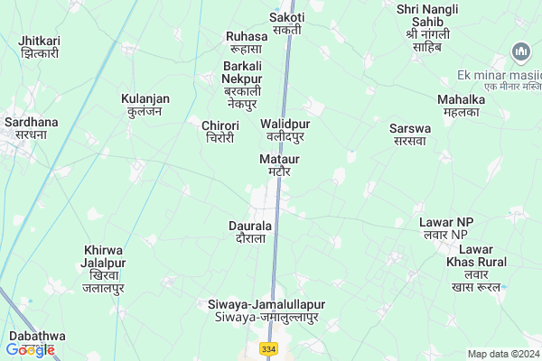
Mataur
Mataur Map
EDIT Map
Add Your House
 ..
..
Current Corona Virus Infected Patients Count in Meerut District
| City Name | District Name | Total Covid cases |
|---|---|---|
| Meerut District | Meerut | 89 |
Locality Name :
Mataur
( मटौर )
Block Name : Daurala
District : Meerut
State : Uttar Pradesh
Division : Meerut
Language : Hindi and Urdu
Current Time 11:25 AM
Date: Wednesday , Feb 05,2025 (IST)
Time zone: IST (UTC+5:30)
Elevation / Altitude: 232 meters. Above Seal level
Telephone Code / Std Code: 01237
Assembly constituency : Sardhana assembly constituency
Assembly MLA : Atul Pradhan
Lok Sabha constituency : Muzaffarnagar parliamentary constituency
Parliament MP : Sanjeev Kumar Balyan
Serpanch Name :
Pin Code : 250221
Post Office Name : Daurala
Commodities Prices : Sardhana Market / Mandi
Mataur Live Weather
Temperature: 21.5 °C
clear sky
Humidity: 43%
Wind : 3.62 mt/sec towards W
StationName : "DaurÄ\u0081la"
observed on Now
Temperature: 21.5 °C
clear sky
Humidity: 43%
Wind : 3.62 mt/sec towards W
StationName : "DaurÄ\u0081la"
observed on Now
Mataur Weather Forecast for Next 5 days
06-02-2025
11.2°C to 24.0°C
clear sky
11.2°C to 24.0°C
clear sky
07-02-2025
10.4°C to 24.6°C
clear sky, broken clouds
10.4°C to 24.6°C
clear sky, broken clouds
08-02-2025
11.3°C to 24.8°C
scattered clouds, clear sky, few clouds
11.3°C to 24.8°C
scattered clouds, clear sky, few clouds
09-02-2025
11.2°C to 26.7°C
few clouds, clear sky, broken clouds, scattered clouds
11.2°C to 26.7°C
few clouds, clear sky, broken clouds, scattered clouds
10-02-2025
12.7°C to 28.3°C
few clouds, scattered clouds, clear sky
12.7°C to 28.3°C
few clouds, scattered clouds, clear sky
Edit below overview about Mataur
Edit below overview about Mataur
OverView of Mataur
Village mataur is situated on roorkee road. Famous for BABA Bihari Das temple and Jharkhandeshwar temple of lord shiva.Edit below overview about Mataur
National Highways Reachable To Mataur
Nationa High Way :NH334
Nationa High Way :NH709A
Nationa High Way :NH334
Nationa High Way :NH709A
Rivers Near Mataur
Hindon River
Kali Nadi
Hindon River
Kali Nadi
About Mataur
Mataur is a Village in Daurala Block in Meerut District of Uttar Pradesh State, India. It belongs to Meerut Division . It is located 19 KM towards North from District head quarters Meerut. 4 KM from Daurala (Rural). 475 KM from State capital Lucknow
Mataur Pin code is 250221 and postal head office is Daurala .
Daurala (rural) ( 2 KM ) , Samoli-salempur ( 2 KM ) , Chirori ( 3 KM ) , Panwari ( 3 KM ) , Kheri Tappa Lawar ( 3 KM ) are the nearby Villages to Mataur. Mataur is surrounded by Sardhana Block towards North , Sarurpur Khurd Block towards west , Mawana Kalan Block towards East , Khatauli Block towards North .
Sardhana , Meerut , Hastinapur , Modinagar are the near by Cities to Mataur.
This Place is in the border of the Meerut District and Muzaffarnagar District. Muzaffarnagar District Khatauli is North towards this place .
Mataur 2011 Census Details
Mataur Local Language is Hindi. Mataur Village Total population is 4891 and number of houses are 925. Female Population is 47.7%. Village literacy rate is 72.3% and the Female Literacy rate is 30.8%.
Population
| Census Parameter | Census Data |
| Total Population | 4891 |
| Total No of Houses | 925 |
| Female Population % | 47.7 % ( 2332) |
| Total Literacy rate % | 72.3 % ( 3538) |
| Female Literacy rate | 30.8 % ( 1504) |
| Scheduled Tribes Population % | 0.0 % ( 0) |
| Scheduled Caste Population % | 28.4 % ( 1390) |
| Working Population % | 30.5 % |
| Child(0 -6) Population by 2011 | 543 |
| Girl Child(0 -6) Population % by 2011 | 43.1 % ( 234) |
Mataur Census More Deatils.
Politics in Mataur
BJP , RLD , BSP are the major political parties in this area.Polling Stations /Booths near Mataur
1)Prathmik Vidhalaya Milak Majra Teharki2)Rajkiya Mahila Poly College Daurala Room No.1
3)Rajkiya Mahila Poly College Daurala Room No.2
4)Rajkiya Mahila Poly College Daurala Room No.3
5)Rahawati Inter College Rahawati R.n.2
HOW TO REACH Mataur
By Rail
Daurala Rail Way Station , Sakhoti Tanda Rail Way Station are the very nearby railway stations to Mataur.Colleges near Mataur
Aadarsh Inter College Sarswa Meerut
Address : Sarswa Daurala Meerut
Adarsh Inter College Samoli Salempur
Address : Samoli Salempur
Schools in Mataur
Sri Mallhu Arya Girls I.colleg
Address : mataur , daurala , meerut , Uttar Pradesh . PIN- 250221 , Post - Daurala
Jn.h.s Mataur
Address : mataur , daurala , meerut , Uttar Pradesh . PIN- 250221 , Post - Daurala
Govt Health Centers near Mataur
1) Dourala Dehat , , ,2) Loiya , , ,
3) Kulanjan , , ,
Schools in Mataur,Daurala
Electronic Shops in Mataur,Daurala
Super Markets in Mataur,Daurala
Local Parks in Mataur,Daurala
Police Stations near Mataur,Daurala
Governement Offices near Mataur,Daurala
About Mataur &
History
How to reach Mataur
Tourist Places Near By Mataur
Schools in Mataur
Colleges in Mataur
Temperature & weather of Mataur
places in Mataur
Mataur photos
More Information
How to reach Mataur
Tourist Places Near By Mataur
Schools in Mataur
Colleges in Mataur
Temperature & weather of Mataur
places in Mataur
Mataur photos
More Information
Village Talk
Post News or Events about this Village
Near Cities
Sardhana 10 KM near
Meerut 17 KM near
Hastinapur 28 KM near
Modinagar 40 KM near
Sardhana 10 KM near
Meerut 17 KM near
Hastinapur 28 KM near
Modinagar 40 KM near
Near By Taluks
Daurala 4 KM near
Sardhana 8 KM near
Sarurpur Khurd 16 KM near
Khatauli 18 KM near
Daurala 4 KM near
Sardhana 8 KM near
Sarurpur Khurd 16 KM near
Khatauli 18 KM near
Near By Air Ports
Muzaffarnagar Airport 38 KM near
Indira Gandhi International Airport 97 KM near
Dehra Dun Airport 151 KM near
Pantnagar Airport 192 KM near
Muzaffarnagar Airport 38 KM near
Indira Gandhi International Airport 97 KM near
Dehra Dun Airport 151 KM near
Pantnagar Airport 192 KM near
Near By Tourist Places
Meerut 17 KM near
Hastinapur 31 KM near
Delhi 81 KM near
Noida 81 KM near
panipat 86 KM near
Meerut 17 KM near
Hastinapur 31 KM near
Delhi 81 KM near
Noida 81 KM near
panipat 86 KM near
Near By Districts
Meerut 18 KM near
Muzaffarnagar 42 KM near
Bijnor 54 KM near
Baghpat 57 KM near
Meerut 18 KM near
Muzaffarnagar 42 KM near
Bijnor 54 KM near
Baghpat 57 KM near
Near By RailWay Station
Daurala Rail Way Station 2.2 KM near
Sakhoti Tanda Rail Way Station 8.2 KM near
Meerut Cantt. Rail Way Station 14 KM near
Khatauli Rail Way Station 18 KM near
Daurala Rail Way Station 2.2 KM near
Sakhoti Tanda Rail Way Station 8.2 KM near
Meerut Cantt. Rail Way Station 14 KM near
Khatauli Rail Way Station 18 KM near