| Home | City Bus | Maps | Villages | Cities | Rail | Tourist Places | School | College | Pin Codes | Corona Cases Count |
| Distance Calculator Bus Services IFSC Codes Trace Mobile Number Weather Search Place Trace IP Available Cash ATM/Banks Locate Polling Booth Report an Error contact People |
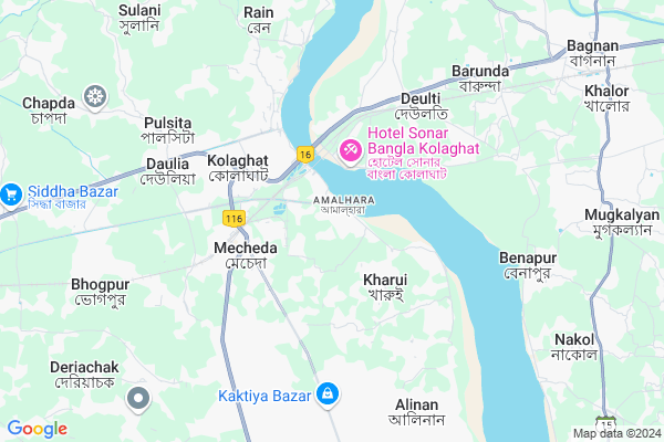
Amalhanda
Amalhanda Map
EDIT Map
Add Your House
 ..
..
Current Corona Virus Infected Patients Count in Medinipur East District
| City Name | District Name | Total Covid cases |
|---|
Locality Name :
Amalhanda
( আমালহান্ডা )
Block Name : Kolaghat
District : Medinipur East
State : West Bengal
Division : Burdwan
Language : Bengali
Current Time 02:31 PM
Date: Monday , Apr 28,2025 (IST)
Time zone: IST (UTC+5:30)
Elevation / Altitude: 9 meters. Above Seal level
Telephone Code / Std Code: 03228
Assembly constituency : Tamluk assembly constituency
Assembly MLA : Saumen Kumar Mahapatra
Lok Sabha constituency : Tamluk parliamentary constituency
Parliament MP : Adhikari Dibyendu
Serpanch Name :
Pin Code : 721134
Post Office Name : Paikpari
Commodities Prices : Kolaghat Market / Mandi
National Highways Reachable To Amalhanda
Nationa High Way :NH16
Nationa High Way :NH16
Rivers Near Amalhanda
Damodar
Rupnarayan :রূপনারায়ণ
Damodar
Rupnarayan :রূপনারায়ণ
About Amalhanda
Correct below Info and add more info about AmalhandaAmalhanda is a Village in Kolaghat Block in Medinipur East District of West Bengal State, India. It belongs to Burdwan Division . It is located 17 KM towards North from District head quarters Tamluk. 8 KM from Kolaghat. 60 KM from State capital Kolkata
Amalhanda Pin code is 721134 and postal head office is Paikpari .
Kolaghat ( 3 KM ) , Sagarbarh ( 8 KM ) , Bhogpur ( 9 KM ) , Kakharda ( 9 KM ) , Deriachak ( 10 KM ) are the nearby Villages to Amalhanda. Amalhanda is surrounded by Kolaghat Block towards west , Bagnan-Ii Block towards East , Bagnan-I Block towards North , Panskura-I Block towards west .
Tamluk , Uluberia , Panchla , Howrah are the near by Cities to Amalhanda.
This Place is in the border of the Medinipur East District and Howrah District. Howrah District Bagnan-i is North towards this place . Also it is in the Border of other district Medinipur West .
Demographics of Amalhanda
Bengali is the Local Language here.Politics in Amalhanda
CPM , AITC , CPI , All India Trinamool Congress are the major political parties in this area.Polling Stations /Booths near Amalhanda
1)Khandagram Atyayik Pry. School2)Kharui (uh)para Kananbala Special Primary Vidyalay(utta) (room-2)
3)Sonapetya High School
4)Shridhar Milan Mandir Granthagar (nichutala)
5)Kharui Banpur M S K
HOW TO REACH Amalhanda
By Rail
Kolaghat Rail Way Station , Mecheda Rail Way Station are the very nearby railway stations to Amalhanda.Colleges near Amalhanda
Palpara College
Address :
Haldia Institute Of Technology
Address :
Moyna College
Address : Moyna, Purba Medinipur, Pin-7216
Mugberia Gangadhar Mahavidyalaya
Address : Vill+p.o- Bhupatinagar,purbamedinipur
Schools in Amalhanda
Amalhanda Primary School
Address : AMALHANDA,KOLAGHAT,721134
Govt Health Centers near Amalhanda
1) Nandaigajan SC , , Bhogpur G.P , Attached Nandaigajan PHC2) Pulsita SC , , Pulsita G.P , Attached Nabarun Seba Nikatan
3) Bhogpur SC , , Bhogpur GP , Near Bhogpur Bhogpur Rly.Station
Hospitals in Amalhanda,Kolaghat
KTPS Hospital
Thermal Power Station; kolaghat;; Kolaghat; West Bengal 721134; India
2.2 KM distance Detail
more ..
Petrol Bunks in Amalhanda,Kolaghat
ALI SERVICES CENTRE
MECHEDA;SHANTIPUR;EAST MED; PURBA MEDINIPUR; West Bengal 721137; India
3.3 KM distance Detail
HP Petrol Pump (Satyanarayan Service Station)
Village - Barisha; District - Purba Medinipur; Kolaghat; West Bengal 721134; India
3.7 KM distance Detail
more ..
Colleges in Amalhanda,Kolaghat
Kolaghat Government Polytechnic College
Kolaghat; Amalhanda; West Bengal 721134; India
1.5 KM distance Detail
INTERNATIONAL INSTITUTE OF MANAGEMENT EDUCATION (IIME); 1NO. Thermal Gate; Mecheda;
Nu-Touch Building; 1no. Thermal Gate; Mecheda; West Bengal 721137; India
3.3 KM distance Detail
Matangini Nursing Training Institute
Shantipur; Thermal Gate (Near Popular Nursing Home); Mecheda; West Bengal 721137; India
3.3 KM distance Detail
more ..
Governement Offices near Amalhanda,Kolaghat
Babua Land Registry Office
Tamluk - Kolaghat Road; Babua P; West Bengal 721134; India
2.0 KM distance Detail
About Amalhanda &
History
How to reach Amalhanda
Tourist Places Near By Amalhanda
Schools in Amalhanda
Colleges in Amalhanda
Temperature & weather of Amalhanda
places in Amalhanda
Amalhanda photos
More Information
How to reach Amalhanda
Tourist Places Near By Amalhanda
Schools in Amalhanda
Colleges in Amalhanda
Temperature & weather of Amalhanda
places in Amalhanda
Amalhanda photos
More Information
Village Talk
Post News or Events about this Village
Near Cities
Tamluk 15 KM near
Uluberia 26 KM near
Panchla 32 KM near
Howrah 49 KM near
Tamluk 15 KM near
Uluberia 26 KM near
Panchla 32 KM near
Howrah 49 KM near
Near By Taluks
Shahid Matangini 4 KM near
Kolaghat 8 KM near
Bagnan-Ii 10 KM near
Bagnan-I 11 KM near
Shahid Matangini 4 KM near
Kolaghat 8 KM near
Bagnan-Ii 10 KM near
Bagnan-I 11 KM near
Near By Air Ports
Netaji Subhas Chandra Bose Airport 69 KM near
Ranchi Airport 315 KM near
Bhubaneswar Airport 361 KM near
Singerbhil Airport 425 KM near
Netaji Subhas Chandra Bose Airport 69 KM near
Ranchi Airport 315 KM near
Bhubaneswar Airport 361 KM near
Singerbhil Airport 425 KM near
Near By Tourist Places
Shankarpur 37 KM near
Raichak 37 KM near
Howrah 48 KM near
Haldia 51 KM near
Alipore 52 KM near
Shankarpur 37 KM near
Raichak 37 KM near
Howrah 48 KM near
Haldia 51 KM near
Alipore 52 KM near
Near By Districts
Medinipur East 16 KM near
Howrah 52 KM near
Kolkata 54 KM near
24 Paraganas South 54 KM near
Medinipur East 16 KM near
Howrah 52 KM near
Kolkata 54 KM near
24 Paraganas South 54 KM near
Near By RailWay Station
Kolaghat Rail Way Station 2.3 KM near
Mecheda Rail Way Station 3.9 KM near
Deulti Rail Way Station 5.2 KM near
Panskura Junction Rail Way Station 17 KM near
Kolaghat Rail Way Station 2.3 KM near
Mecheda Rail Way Station 3.9 KM near
Deulti Rail Way Station 5.2 KM near
Panskura Junction Rail Way Station 17 KM near