| Home | City Bus | Maps | Villages | Cities | Rail | Tourist Places | School | College | Pin Codes | Corona Cases Count |
| Distance Calculator Bus Services IFSC Codes Trace Mobile Number Weather Search Place Trace IP Available Cash ATM/Banks Locate Polling Booth Report an Error contact People |
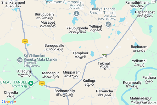
Tamploor Map
EDIT Map
Add Your House
 ..
..
Current Corona Virus Infected Patients Count in Medak District
| City Name | District Name | Total Covid cases |
|---|---|---|
| Sangareddy District | Sangareddy | 7 |
| Medak District | Medak | 5 |
Locality Name :
Tamploor
( ఠంప్లోర్ )
Mandal Name : Tekmal
District : Medak
State : Telangana
Region : Telangana
Language : Telugu
Current Time 12:49 PM
Date: Tuesday , Apr 29,2025 (IST)
Time zone: IST (UTC+5:30)
Elevation / Altitude: 530 meters. Above Seal level
Telephone Code / Std Code: 08681
Assembly constituency : Andole assembly constituency
Assembly MLA : C. Damodar Rajanarsimha
Lok Sabha constituency : Zahirabad parliamentary constituency
Parliament MP : B.B.PATIL
Serpanch Name :
Pin Code : 502302
Post Office Name : Tekmal
Alternate Village Name : Thamploor
Commodities Prices : Yellareddy Market / Mandi
Edit below overview about Tamploor
Edit below overview about Tamploor
OverView of Tamploor
In Thamploor village nearly 20 Ponds are there four ponds surrounded by village,and 10 th standard school are thereEdit below overview about Tamploor
National Highways Reachable To Tamploor
Nationa High Way :Old NH7
Nationa High Way :NH50
Nationa High Way :Old NH7
Nationa High Way :NH50
Rivers Near Tamploor
Manjira :Manjira :मांजरा :ಮಂಜೀರ :मांजरा :మంజీర
Haldi
Manjira :Manjira :मांजरा :ಮಂಜೀರ :मांजरा :మంజీర
Haldi
About Tamploor
Tamploor is a Village in Tekmal Mandal in Medak District of Telangana State, India. It belongs to Telangana region . It is located 48 KM towards North from District head quarters Sangareddi. 5 KM from Tekmal.
Tamploor Pin code is 502302 and postal head office is Tekmal .
Tekmal ( 4 KM ) , Kadloor ( 4 KM ) , Yellampalle ( 4 KM ) , Mahammadapur ( 4 KM ) , Yellupet ( 4 KM ) are the nearby Villages to Tamploor. Tamploor is surrounded by Alladurg Mandal towards South , Shankarampet[A] Mandal towards west , Papannapet Mandal towards East , Regode Mandal towards west .
Medak , Sadasivpet , Sangareddy , Kamareddy are the near by Cities to Tamploor.
This Place is in the border of the Medak District and Nizamabad District. Nizamabad District Nagireddypet is North towards this place .
Tamploor 2011 Census Details
Tamploor Local Language is Telugu. Tamploor Village Total population is 2145 and number of houses are 456. Female Population is 52.1%. Village literacy rate is 43.5% and the Female Literacy rate is 19.5%.
Population
| Census Parameter | Census Data |
| Total Population | 2145 |
| Total No of Houses | 456 |
| Female Population % | 52.1 % ( 1117) |
| Total Literacy rate % | 43.5 % ( 933) |
| Female Literacy rate | 19.5 % ( 419) |
| Scheduled Tribes Population % | 0.0 % ( 0) |
| Scheduled Caste Population % | 27.2 % ( 583) |
| Working Population % | 51.9 % |
| Child(0 -6) Population by 2011 | 292 |
| Girl Child(0 -6) Population % by 2011 | 51.7 % ( 151) |
Tamploor Census More Deatils.
Politics in Tamploor
TDP , TRS , INC are the major political parties in this area.Polling Stations /Booths near Tamploor
1)Talelma2)Tamplur
3)Saipeta
4)Sarafpally Badri Gudem
5)Munipally
HOW TO REACH Tamploor
By Road
Medak is the Nearest Town to Tamploor. Medak is 40 km from Tamploor. Road connectivity is there from Medak to Tamploor.By Rail
There is no railway station near to Tamploor in less than 10 km.Colleges near Tamploor
Govt Junior College Tekmal
Address : Govt Junior College Tekmal
Schools in Tamploor
Zphs Tamploor
Address : tamploor , tekmal , medak , Andhra Pradesh . PIN- 502302 , Post - Tekmal
Govt Health Centers near Tamploor
1) SubCentre, Mupparam , 1-89/1 , BC COLONY , NEAR GP2) Primary Health Centre Tekmal , 1/1/2001 , GOLLAGUDEM , NEAR IB
3) SubCentre Tekmal , May-49 , KUMMARIGALLY , NEAR BUSTAND
Sub Villages in Tamploor
Petrol Bunks in Tamploor,Tekmal
Sri Rajarajeshwari Filling Station
Medak - Bodmatpally Rd; Tamploor; Telangana 502302; India
3.5 KM distance Detail
more ..
Electronic Shops in Tamploor,Tekmal
Sri Lakshmi Engineering And Electronical Works
Bodmatpally; Telangana 502269; India
7.0 KM distance Detail
Pantulu Cool Drinks And Mobiles
Pantulu Cool Drinks and Mobiles.; Papannapet; Telangana; India
12.3 KM distance Detail
Governement Offices near Tamploor,Tekmal
MeeSeva Center
3-80; Hotline Photo Studio; Near Bus Stand; Tekmal; Telangana 502302; India
4.6 KM distance Detail
About Tamploor &
History
How to reach Tamploor
Tourist Places Near By Tamploor
Schools in Tamploor
Colleges in Tamploor
Temperature & weather of Tamploor
places in Tamploor
Tamploor photos
More Information
How to reach Tamploor
Tourist Places Near By Tamploor
Schools in Tamploor
Colleges in Tamploor
Temperature & weather of Tamploor
places in Tamploor
Tamploor photos
More Information
Village Talk
Post News or Events about this Village
Near Cities
Medak 32 KM near
Sadasivpet 46 KM near
Sangareddy 47 KM near
Kamareddy 56 KM near
Medak 32 KM near
Sadasivpet 46 KM near
Sangareddy 47 KM near
Kamareddy 56 KM near
Near By Taluks
Tekmal 5 KM near
Alladurg 11 KM near
Shankarampet[A] 12 KM near
Papannapet 14 KM near
Tekmal 5 KM near
Alladurg 11 KM near
Shankarampet[A] 12 KM near
Papannapet 14 KM near
Near By Air Ports
Rajiv Gandhi International Airport 106 KM near
Nanded Airport 169 KM near
Latur Airport 188 KM near
Sholapur Airport 249 KM near
Rajiv Gandhi International Airport 106 KM near
Nanded Airport 169 KM near
Latur Airport 188 KM near
Sholapur Airport 249 KM near
Near By Tourist Places
Medak 32 KM near
Bidar 54 KM near
Hyderabad 94 KM near
Gulbarga 160 KM near
Warangal 190 KM near
Medak 32 KM near
Bidar 54 KM near
Hyderabad 94 KM near
Gulbarga 160 KM near
Warangal 190 KM near
Near By Districts
Medak 46 KM near
Bidar 57 KM near
Nizamabad 85 KM near
Hyderabad 88 KM near
Medak 46 KM near
Bidar 57 KM near
Nizamabad 85 KM near
Hyderabad 88 KM near
Near By RailWay Station
Kamareddi Rail Way Station 57 KM near
Bidar Rail Way Station 58 KM near
Kamareddi Rail Way Station 57 KM near
Bidar Rail Way Station 58 KM near