| Home | City Bus | Maps | Villages | Cities | Rail | Tourist Places | School | College | Pin Codes | Corona Cases Count |
| Distance Calculator Bus Services IFSC Codes Trace Mobile Number Weather Search Place Trace IP Available Cash ATM/Banks Locate Polling Booth Report an Error contact People |
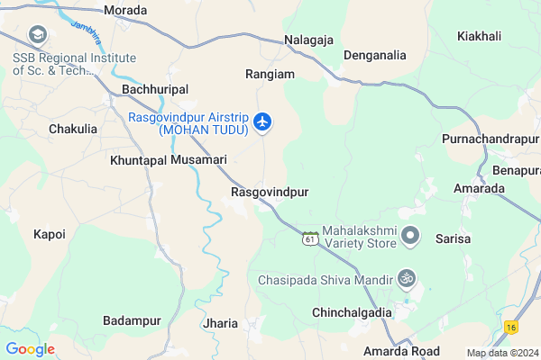
Rasgovindpur
Rasgovindpur Map
EDIT Map
Add Your House
 ..
..
Current Corona Virus Infected Patients Count in Mayurbhanj District
| City Name | District Name | Total Covid cases |
|---|
Locality Name :
Rasgovindpur
( ରାସଗୋବିନ୍ଦପୁର )
Tehsil Name : Rasgovindpur
District : Mayurbhanj
State : Odisha
Language : Oriya and Hindi
Current Time 05:27 PM
Date: Tuesday , Apr 29,2025 (IST)
Time zone: IST (UTC+5:30)
Telephone Code / Std Code: 06793
Assembly constituency : Morada assembly constituency
Assembly MLA : praveen chandra bhanjdeo
Lok Sabha constituency : Mayurbhanj parliamentary constituency
Parliament MP : BISHWESWAR TUDU
Serpanch Name :
Pin Code : 757016
Post Office Name : Rasgovindpur
Alternate Village Name : Rasagovindpur
Commodities Prices : Jaleswar Market / Mandi
Rasgovindpur Live Weather
Temperature: 33.2 °C
clear sky
Humidity: 50%
Wind : 7.13 mt/sec towards S
StationName : "Jaleshwar"
observed on 2 Hours Back
Temperature: 33.2 °C
clear sky
Humidity: 50%
Wind : 7.13 mt/sec towards S
StationName : "Jaleshwar"
observed on 2 Hours Back
Rasgovindpur Weather Forecast for Next 5 days
30-04-2025
24.8°C to 31.1°C
moderate rain, light rain, broken clouds, overcast clouds
24.8°C to 31.1°C
moderate rain, light rain, broken clouds, overcast clouds
01-05-2025
23.4°C to 34.7°C
broken clouds, clear sky, light rain, moderate rain, overcast clouds
23.4°C to 34.7°C
broken clouds, clear sky, light rain, moderate rain, overcast clouds
02-05-2025
23.4°C to 33.7°C
scattered clouds, clear sky, moderate rain, light rain, overcast clouds
23.4°C to 33.7°C
scattered clouds, clear sky, moderate rain, light rain, overcast clouds
03-05-2025
23.7°C to 34.3°C
broken clouds, clear sky, few clouds, light rain, scattered clouds
23.7°C to 34.3°C
broken clouds, clear sky, few clouds, light rain, scattered clouds
04-05-2025
26.1°C to 37.2°C
broken clouds, clear sky, light rain, moderate rain, overcast clouds
26.1°C to 37.2°C
broken clouds, clear sky, light rain, moderate rain, overcast clouds
National Highways Reachable To Rasgovindpur
Nationa High Way :NH116B;SH4
Nationa High Way :NH116B;SH4
Rivers Near Rasgovindpur
Subarnarekha River
Budhabalanga
Subarnarekha River
Budhabalanga
About Rasgovindpur
Correct below Info and add more info about RasgovindpurRasgovindpur is a Town in Rasgovindpur Tehsil in Mayurbhanj District of Odisha State, India. It is located 42 KM towards East from District head quarters Baripada. It is a Tehsil head quarter.
Rasgovindpur Pin code is 757016 and postal head office is Rasgovindpur .
Nakichua ( 4 KM ) , Kamardiha ( 8 KM ) , Badampur ( 8 KM ) , Amarda ( 9 KM ) , Raghabpur ( 10 KM ) are the nearby Villages to Rasgovindpur. Rasgovindpur is surrounded by Basta Tehsil towards South , Morada Tehsil towards west , Jaleswar Tehsil towards East , Betnoti Tehsil towards west .
Jaleswar , Balasore , Baleshwar , Baripada are the nearby Cities to Rasgovindpur.
Rasagovindpur 2011 Census Details
Rasgovindpur Local Language is Oriya. Rasagovindpur town Total population is 1961 and number of houses are 470. Female Population is 47.7%. town literacy rate is 75.9% and the Female Literacy rate is 33.9%.
Population
| Census Parameter | Census Data |
| Total Population | 1961 |
| Total No of Houses | 470 |
| Female Population % | 47.7 % ( 936) |
| Total Literacy rate % | 75.9 % ( 1489) |
| Female Literacy rate | 33.9 % ( 665) |
| Scheduled Tribes Population % | 16.4 % ( 322) |
| Scheduled Caste Population % | 3.8 % ( 74) |
| Working Population % | 36.1 % |
| Child(0 -6) Population by 2011 | 239 |
| Girl Child(0 -6) Population % by 2011 | 43.1 % ( 103) |
Rasagovindpur Census More Deatils.
Demographics of Rasgovindpur
Oriya is the Local Language here.Politics in Rasgovindpur
SWA , PSP , BJD are the major political parties in this area.Polling Stations /Booths near Rasgovindpur
1)Sukhilakhali P.s2)Tarapur Ps
3)Rangiam Ups
4)Parulia Hs
5)Murgapahadi S/a
HOW TO REACH Rasgovindpur
By Rail
Amarda Road Rail Way Station , Basta Rail Way Station are the very nearby railway stations to Rasgovindpur.Govt Health Centers near Rasgovindpur
1) Sunhat OH , Sunhat OH , Sunhat , Near SBI ATM2) SABARANGA , , , L.I CENTRE
Hospitals in Rasgovindpur,Rasgovindpur
SHREE RAM PATHOLOGY ;RASGOVINDPUR
MAYURBHANJ; Rasgovindpur; Odisha 757016; India
0.5 KM distance Detail
Mahatma Gandhi Eye Hospital;rangamatia
Rasogovindpur; Rangamatia; Odisha; India
2.1 KM distance Detail
more ..
Colleges in Rasgovindpur,Rasgovindpur
Anla Junior College
Haripur; Anla Urban Patch; Sanajahata; Odisha 757052; India
12.2 KM distance Detail
more ..
Schools in Rasgovindpur,Rasgovindpur
Odisha Adarsha Vidyalaya Mahulia Rasgobindpur
Rasgovindpur; Odisha 757016; India
0.4 KM distance Detail
Rasgovindpur Upper Primary School
Rasgovindpur; Mayurbhanj; SH-61; Baripada Amarda Road; Baripada; Baripada; Odisha 757016; India
1.0 KM distance Detail
Local Parks in Rasgovindpur,Rasgovindpur
About Rasgovindpur &
History
How to reach Rasgovindpur
Tourist Places Near By Rasgovindpur
Schools in Rasgovindpur
Colleges in Rasgovindpur
Temperature & weather of Rasgovindpur
places in Rasgovindpur
Rasgovindpur photos
More Information
How to reach Rasgovindpur
Tourist Places Near By Rasgovindpur
Schools in Rasgovindpur
Colleges in Rasgovindpur
Temperature & weather of Rasgovindpur
places in Rasgovindpur
Rasgovindpur photos
More Information
Town Talk
Post News or Events about this Town
Near Cities
Jaleswar 21 KM near
Balasore 39 KM near
Baleshwar 40 KM near
Baripada 41 KM near
Jaleswar 21 KM near
Balasore 39 KM near
Baleshwar 40 KM near
Baripada 41 KM near
Near By Taluks
Rasgovindpur 1 KM near
Basta 15 KM near
Morada 16 KM near
Jaleswar 21 KM near
Rasgovindpur 1 KM near
Basta 15 KM near
Morada 16 KM near
Jaleswar 21 KM near
Near By Air Ports
Netaji Subhas Chandra Bose Airport 192 KM near
Bhubaneswar Airport 239 KM near
Ranchi Airport 275 KM near
Gaya Airport 439 KM near
Netaji Subhas Chandra Bose Airport 192 KM near
Bhubaneswar Airport 239 KM near
Ranchi Airport 275 KM near
Gaya Airport 439 KM near
Near By Tourist Places
Baripada 40 KM near
Chandipur 42 KM near
Digha 58 KM near
Mandarmani 59 KM near
Barehipani & Joranda Barehipani & Joranda Falls 83 KM near
Baripada 40 KM near
Chandipur 42 KM near
Digha 58 KM near
Mandarmani 59 KM near
Barehipani & Joranda Barehipani & Joranda Falls 83 KM near
Near By Districts
Mayurbhanj 40 KM near
Baleshwar 40 KM near
Medinipur West 84 KM near
Bhadrak 109 KM near
Mayurbhanj 40 KM near
Baleshwar 40 KM near
Medinipur West 84 KM near
Bhadrak 109 KM near
Near By RailWay Station
Basta Rail Way Station 11 KM near
Jaleswar Rail Way Station 19 KM near
Basta Rail Way Station 11 KM near
Jaleswar Rail Way Station 19 KM near