| Home | City Bus | Maps | Villages | Cities | Rail | Tourist Places | School | College | Pin Codes | Corona Cases Count |
| Distance Calculator Bus Services IFSC Codes Trace Mobile Number Weather Search Place Trace IP Available Cash ATM/Banks Locate Polling Booth Report an Error contact People |
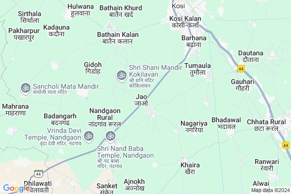
Jao
Jao Map
EDIT Map
Add Your House
 ..
..
Current Corona Virus Infected Patients Count in Mathura District
| City Name | District Name | Total Covid cases |
|---|---|---|
| Mathura District | Mathura | 10 |
Locality Name :
Jao
( जाओ )
Block Name : Chhata
District : Mathura
State : Uttar Pradesh
Division : Agra
Language : Hindi and Urdu
Current Time 04:07 PM
Date: Monday , Apr 28,2025 (IST)
Time zone: IST (UTC+5:30)
Elevation / Altitude: 185 meters. Above Seal level
Telephone Code / Std Code: 05662
Assembly constituency : Chhata assembly constituency
Assembly MLA : Laxmi Narayan
Lok Sabha constituency : Mathura parliamentary constituency
Parliament MP : HEMA MALINI
Serpanch Name :
Pin Code : 281403
Post Office Name : Kosi Kalan
Commodities Prices : Kosikalan Market / Mandi
National Highways Reachable To Jao
Nationa High Way :NH509
Nationa High Way :NH509
Rivers Near Jao
Karwan Nadi
यमुना (Yamuna) :যমুনা :Yamuna :યમુના :यमुना :ಯಮುನಾ :यमुना :யமுனை :Ямуна :https://1drv.ms/b/s!Ar-WXIFaX7UdgQuO6WpVrTr6YYsQ
Karwan Nadi
यमुना (Yamuna) :যমুনা :Yamuna :યમુના :यमुना :ಯಮುನಾ :यमुना :யமுனை :Ямуна :https://1drv.ms/b/s!Ar-WXIFaX7UdgQuO6WpVrTr6YYsQ
About Jao
Correct below Info and add more info about JaoJao is a Village in Chhata Block in Mathura District of Uttar Pradesh State, India. It belongs to Agra Division . It is located 44 KM towards North from District head quarters Mathura. 12 KM from Chhata. 425 KM from State capital Lucknow
Jao Pin code is 281403 and postal head office is Kosi Kalan .
Nandgaon ( 3 KM ) , Surwari ( 4 KM ) , Tumaula ( 4 KM ) , Gidoh ( 4 KM ) , Dham Singha ( 4 KM ) are the nearby Villages to Jao. Jao is surrounded by Chhata Block towards East , Chaumuha Block towards East , Kaman Block towards west , Punahana Block towards west .
Hodal , Vrindavan , Mathura , Nagar are the near by Cities to Jao.
Jao 2011 Census Details
Jao Local Language is Hindi. Jao Village Total population is 4635 and number of houses are 752. Female Population is 46.2%. Village literacy rate is 53.2% and the Female Literacy rate is 18.2%.
Population
| Census Parameter | Census Data |
| Total Population | 4635 |
| Total No of Houses | 752 |
| Female Population % | 46.2 % ( 2142) |
| Total Literacy rate % | 53.2 % ( 2468) |
| Female Literacy rate | 18.2 % ( 844) |
| Scheduled Tribes Population % | 0.0 % ( 0) |
| Scheduled Caste Population % | 20.8 % ( 965) |
| Working Population % | 27.4 % |
| Child(0 -6) Population by 2011 | 826 |
| Girl Child(0 -6) Population % by 2011 | 45.5 % ( 376) |
Jao Census More Deatils.
Politics in Jao
ABLTC , BJP , RLD , BSP , INC are the major political parties in this area.Polling Stations /Booths near Jao
1)Primary School Jaitpur2)Poorv Madhyamik Vidyalay Hulwana Room No 2
3)Primary School Falain
4)Primary School Nagla Audhoota
5)Poorv Madhyamik Vidyalay Kharaut Room No 2
HOW TO REACH Jao
By Rail
Kosi Kalan Rail Way Station , Chata Rail Way Station are the very nearby railway stations to Jao.Colleges near Jao
Jaswant Singh Bhadauria Institute Of Technology Kosi Khurd Mathura
Address :
Captain Rakesh Iti College Bharnakalan
Address :
Sri Mohar Singh Mahavidyalaya, Nanakpur Mathura
Address : Nanakpur, Nohjheel
D. K. Institute Of Management & Technology
Address :
Captain Rakesh Polytechnic College Bharnakalan Mathura
Address :
Schools in Jao
Vijay Ratan Inter C Ollege Nandgaon Road Jab Chhata Mathura
Address : NANDGAON ROAD JAB KOSIKALAN MATHURA
Govt Health Centers near Jao
1) Jaav , , ,2) Bathenkalan , bathenkalan , bathenkalan , bathenkalan
3) Khayra , , , pani ki tanki
Schools in Jao,Chhata
Electronic Shops in Jao,Chhata
Super Markets in Jao,Chhata
Local Parks in Jao,Chhata
Police Stations near Jao,Chhata
Governement Offices near Jao,Chhata
About Jao &
History
How to reach Jao
Tourist Places Near By Jao
Schools in Jao
Colleges in Jao
Temperature & weather of Jao
places in Jao
Jao photos
More Information
How to reach Jao
Tourist Places Near By Jao
Schools in Jao
Colleges in Jao
Temperature & weather of Jao
places in Jao
Jao photos
More Information
Village Talk
Post News or Events about this Village
Near Cities
Hodal 19 KM near
Vrindavan 37 KM near
Mathura 42 KM near
Nagar 51 KM near
Hodal 19 KM near
Vrindavan 37 KM near
Mathura 42 KM near
Nagar 51 KM near
Near By Taluks
Nandgaon 5 KM near
Chhata 11 KM near
Chaumuha 19 KM near
Kaman 22 KM near
Nandgaon 5 KM near
Chhata 11 KM near
Chaumuha 19 KM near
Kaman 22 KM near
Near By Air Ports
Kheria Airport 94 KM near
Indira Gandhi International Airport 107 KM near
Gwalior Airport 201 KM near
Sanganeer Airport 211 KM near
Kheria Airport 94 KM near
Indira Gandhi International Airport 107 KM near
Gwalior Airport 201 KM near
Sanganeer Airport 211 KM near
Near By Tourist Places
Dabchick 20 KM near
Govardhan 30 KM near
Vrindavan 37 KM near
Mathura 42 KM near
Nuh 63 KM near
Dabchick 20 KM near
Govardhan 30 KM near
Vrindavan 37 KM near
Mathura 42 KM near
Nuh 63 KM near
Near By Districts
Mathura 42 KM near
Palwal 52 KM near
Mewat 63 KM near
Bharatpur 65 KM near
Mathura 42 KM near
Palwal 52 KM near
Mewat 63 KM near
Bharatpur 65 KM near
Near By RailWay Station
Kosi Kalan Rail Way Station 7.5 KM near
Chata Rail Way Station 9 KM near
Kosi Kalan Rail Way Station 7.5 KM near
Chata Rail Way Station 9 KM near