| Home | City Bus | Maps | Villages | Cities | Rail | Tourist Places | School | College | Pin Codes | Corona Cases Count |
| Distance Calculator Bus Services IFSC Codes Trace Mobile Number Weather Search Place Trace IP Available Cash ATM/Banks Locate Polling Booth Report an Error contact People |
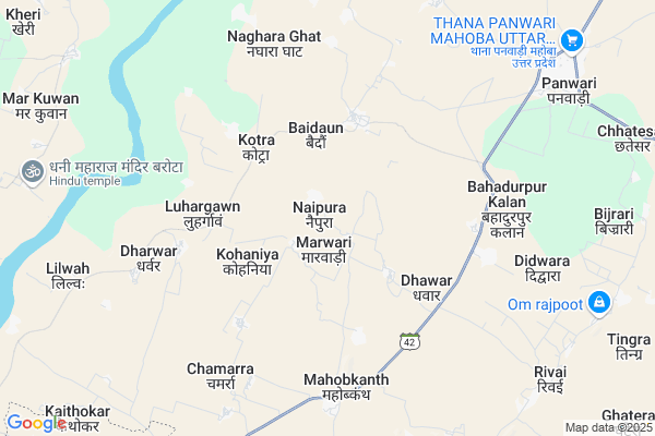
Naipura
Naipura Map
EDIT Map
Add Your House
 ..
..
Current Corona Virus Infected Patients Count in Mahoba District
| City Name | District Name | Total Covid cases |
|---|
Locality Name :
Naipura
( नैपुरा )
Block Name : Panwari
District : Mahoba
State : Uttar Pradesh
Division : Chitrakoot
Language : Hindi and Urdu
Current Time 11:25 AM
Date: Wednesday , Feb 05,2025 (IST)
Time zone: IST (UTC+5:30)
Elevation / Altitude: 196 meters. Above Seal level
Telephone Code / Std Code: 05280
Assembly constituency : assembly constituency
Assembly MLA :
Lok Sabha constituency : parliamentary constituency
Parliament MP :
Serpanch Name :
Pin Code : 210429
Post Office Name : Panwari
Commodities Prices : Harpalpur Market / Mandi
Naipura Live Weather
Temperature: 25.3 °C
clear sky
Humidity: 42%
Wind : 4.21 mt/sec towards NW
StationName : "HarpÄ\u0081lpur"
observed on Now
Temperature: 25.3 °C
clear sky
Humidity: 42%
Wind : 4.21 mt/sec towards NW
StationName : "HarpÄ\u0081lpur"
observed on Now
Naipura Weather Forecast for Next 5 days
06-02-2025
12.8°C to 28.0°C
clear sky
12.8°C to 28.0°C
clear sky
07-02-2025
11.2°C to 25.9°C
clear sky, scattered clouds
11.2°C to 25.9°C
clear sky, scattered clouds
08-02-2025
11.0°C to 26.3°C
few clouds, clear sky, scattered clouds, overcast clouds
11.0°C to 26.3°C
few clouds, clear sky, scattered clouds, overcast clouds
09-02-2025
12.0°C to 28.1°C
overcast clouds, scattered clouds, broken clouds
12.0°C to 28.1°C
overcast clouds, scattered clouds, broken clouds
10-02-2025
14.0°C to 30.5°C
scattered clouds, clear sky, broken clouds
14.0°C to 30.5°C
scattered clouds, clear sky, broken clouds
Rivers Near Naipura
Dhasan
Lakheri
Dhasan
Lakheri
About Naipura
Correct below Info and add more info about NaipuraNaipura is a Village in Panwari Block in Mahoba District of Uttar Pradesh State, India. It belongs to Chitrakoot Division . It is located 57 KM towards west from District head quarters Mahoba. 6 KM from Panwari. 261 KM from State capital Lucknow
Naipura Pin code is 210429 and postal head office is Panwari .
Baidaun ( 3 KM ) , Kohaniya ( 3 KM ) , Kotra ( 3 KM ) , Luhargawn ( 4 KM ) , Dhawar ( 4 KM ) are the nearby Villages to Naipura. Naipura is surrounded by Rath Block towards North , Gursarai Block towards west , Jaitpur Block towards South , Mauranipur Block towards west .
Rath , Niwari , Charkhari , Nowgong are the near by Cities to Naipura.
Naipura 2011 Census Details
Naipura Local Language is Hindi. Naipura Village Total population is 2247 and number of houses are 448. Female Population is 45.2%. Village literacy rate is 56.3% and the Female Literacy rate is 21.1%.
Population
| Census Parameter | Census Data |
| Total Population | 2247 |
| Total No of Houses | 448 |
| Female Population % | 45.2 % ( 1016) |
| Total Literacy rate % | 56.3 % ( 1265) |
| Female Literacy rate | 21.1 % ( 474) |
| Scheduled Tribes Population % | 0.0 % ( 0) |
| Scheduled Caste Population % | 20.2 % ( 454) |
| Working Population % | 49.9 % |
| Child(0 -6) Population by 2011 | 320 |
| Girl Child(0 -6) Population % by 2011 | 40.3 % ( 129) |
Naipura Census More Deatils.
HOW TO REACH Naipura
By Rail
There is no railway station near to Naipura in less than 10 km.Colleges near Naipura
Nehru Inter College
Address :
B N M
Address : Mahoba Road
B N M
Address : Mahoba Road
B N M
Address : Mahoba Road
Schools in Naipura
J.h.s.naipura
Address : naipura , panwari , mahoba , Uttar Pradesh . PIN- 210429 , Post - Panwari
Govt Health Centers near Naipura
1) CHC Panwari , Panwari , rath road ,2) Jhakha , chc panwari , rath road ,
3) Bharwara , Bharwara , Bharwara ,
Hospitals in Naipura,Panwari
Government Hospital
National Highway 76; Panwari; Uttar Pradesh 210429; India
8.9 KM distance Detail
more ..
Colleges in Naipura,Panwari
Jantantra Inter College
Mahoba; NH-76; Banda Jhansi Road; Kulpahad; Kulpahad; Uttar Pradesh 210423; India
9.6 KM distance Detail
Bundelkahnd Navoday Mahavidyalay Panwaei
Mahoba; Uttar Pradesh 210429; India
10.7 KM distance Detail
more ..
Schools in Naipura,Panwari
Shree Ram Janki Junior High School Mahobkanth
Mahobkanth; Uttar Pradesh 210429; India
6.8 KM distance Detail
Governement Offices near Naipura,Panwari
PRAJAPATI VANI (Distt. Office)
PRAJAPATI bhawan main market; Panwari; Uttar Pradesh 210429; India
9.9 KM distance Detail
About Naipura &
History
How to reach Naipura
Tourist Places Near By Naipura
Schools in Naipura
Colleges in Naipura
Temperature & weather of Naipura
places in Naipura
Naipura photos
More Information
How to reach Naipura
Tourist Places Near By Naipura
Schools in Naipura
Colleges in Naipura
Temperature & weather of Naipura
places in Naipura
Naipura photos
More Information
Village Talk
Post News or Events about this Village
Near Cities
Rath 32 KM near
Niwari 35 KM near
Charkhari 38 KM near
Nowgong 41 KM near
Rath 32 KM near
Niwari 35 KM near
Charkhari 38 KM near
Nowgong 41 KM near
Near By Taluks
Panwari 5 KM near
Rath 25 KM near
Jaitpur 25 KM near
Gursarai 26 KM near
Panwari 5 KM near
Rath 25 KM near
Jaitpur 25 KM near
Gursarai 26 KM near
Near By Air Ports
Khajuraho Airport 91 KM near
Kanpur Airport 169 KM near
Gwalior Airport 172 KM near
Amausi Airport 238 KM near
Khajuraho Airport 91 KM near
Kanpur Airport 169 KM near
Gwalior Airport 172 KM near
Amausi Airport 238 KM near
Near By Tourist Places
Orchha 86 KM near
Khajuraho 90 KM near
Jhansi 93 KM near
Datia 110 KM near
Ajaigarh 114 KM near
Orchha 86 KM near
Khajuraho 90 KM near
Jhansi 93 KM near
Datia 110 KM near
Ajaigarh 114 KM near
Near By Districts
Mahoba 54 KM near
Chhatarpur 63 KM near
Jhansi 92 KM near
Jalaun 94 KM near
Mahoba 54 KM near
Chhatarpur 63 KM near
Jhansi 92 KM near
Jalaun 94 KM near
Near By RailWay Station
Harpalpur Rail Way Station 14 KM near
Kulpahar Rail Way Station 29 KM near
Harpalpur Rail Way Station 14 KM near
Kulpahar Rail Way Station 29 KM near