| Home | City Bus | Maps | Villages | Cities | Rail | Tourist Places | School | College | Pin Codes | Corona Cases Count |
| Distance Calculator Bus Services IFSC Codes Trace Mobile Number Weather Search Place Trace IP Available Cash ATM/Banks Locate Polling Booth Report an Error contact People |
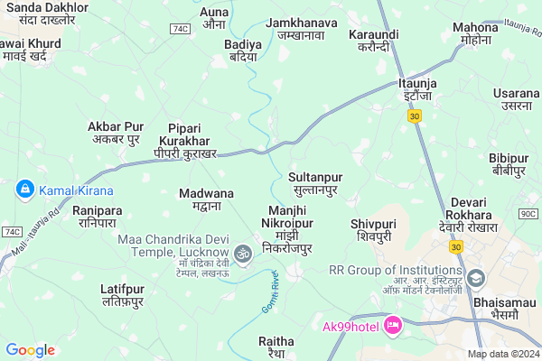
Ataria
Ataria Map
EDIT Map
Add Your House
 ..
..
Current Corona Virus Infected Patients Count in Lucknow District
| City Name | District Name | Total Covid cases |
|---|---|---|
| Lucknow District | Lucknow | 185 |
| Lucknow | Lucknow | 7 |
Locality Name :
Ataria
( अतरिअ )
Block Name : Mal
District : Lucknow
State : Uttar Pradesh
Division : Lucknow
Language : Hindi and Urdu, Awadhi
Current Time 12:49 PM
Date: Tuesday , Apr 29,2025 (IST)
Time zone: IST (UTC+5:30)
Elevation / Altitude: 133 meters. Above Seal level
Telephone Code / Std Code: 05212
Assembly constituency : Malihabad assembly constituency
Assembly MLA : Jai Devi
Lok Sabha constituency : Mohanlalganj parliamentary constituency
Parliament MP : Kaushal Kishore
Serpanch Name :
Pin Code : 221715
Post Office Name : Bilthra Road RS
Main Village Name : Madwana
Commodities Prices : Lucknow Market / Mandi
National Highways Reachable To Ataria
Nationa High Way :NH28
Nationa High Way :NH30
Nationa High Way :NH28
Nationa High Way :NH30
Rivers Near Ataria
Gomtī :Gomti River :गोमती
Gomtī :Gomti River :गोमती
About Ataria
Correct below Info and add more info about AtariaAtaria is a small Village/hamlet in Mal Block in Lucknow District of Uttar Pradesh State, India. It comes under Madwana Panchayath. It belongs to Lucknow Division . It is located 29 KM towards North from District head quarters Lucknow. 11 KM from Mal. 29 KM from State capital Lucknow
Ataria Pin code is 221715 and postal head office is Bilthra Road RS .
Manjhi Nikrojpur ( 2 KM ) , Madwana ( 3 KM ) , Shivpuri ( 3 KM ) , Kathwara ( 4 KM ) , Dudhara ( 4 KM ) are the nearby Villages to Ataria. Ataria is surrounded by Mal Block towards west , Bharawan Block towards west , Sidhauli Block towards North , Malihabad Block towards South .
Lucknow , Sandila , Zaidpur , Sitapur are the near by Cities to Ataria.
Ataria 2011 Census Details
Ataria Local Language is Hindi. Ataria Village Total population is 810 and number of houses are 133. Female Population is 49.8%. Village literacy rate is 57.8% and the Female Literacy rate is 26.5%.
Population
| Census Parameter | Census Data |
| Total Population | 810 |
| Total No of Houses | 133 |
| Female Population % | 49.8 % ( 403) |
| Total Literacy rate % | 57.8 % ( 468) |
| Female Literacy rate | 26.5 % ( 215) |
| Scheduled Tribes Population % | 0.0 % ( 0) |
| Scheduled Caste Population % | 20.9 % ( 169) |
| Working Population % | 25.6 % |
| Child(0 -6) Population by 2011 | 116 |
| Girl Child(0 -6) Population % by 2011 | 48.3 % ( 56) |
Ataria Census More Deatils.
Politics in Ataria
SP , RCP , BSP , are the major political parties in this area.Polling Stations /Booths near Ataria
1)P.s.atari Room No-22)P.s.narayanpur Room No-1
3)P.s.lodhkheda Room No-1
4)P.s.bahir Room No-1
5)P.s.bhadwana Room No-1
HOW TO REACH Ataria
By Rail
Itaunja Rail Way Station is the very nearby railway stations to Ataria.Colleges near Ataria
Shree Mahesh Shingh Inter College Mohalla-latifpur Mal Lucknow
Address :
N S Sinter Collage Masedha Hameer
Address :
Shree Mahesh Shingh Inter College Mohalla-latifpur Mal Lucknowmohalla
Address :
Schools in Ataria
P.s. Ataria
Address : ataria , maal , lucknow , Uttar Pradesh . PIN- 221715 , Post - Bilthra Road RS
Govt Health Centers near Ataria
1) CHC Itaunja , CHC ITAUNJA , SITAPUR ROAD , NEAR PRIMARY SCHOOL2) Itaunja-2 , sub centar bulding , itaunja , chc itaunja
3) Itaunja-1 , ITAUNJA , SITAPUR ROADD , PRIMARY SCHOOL
Petrol Bunks in Ataria,Mal
Hamara Pump Raipur Raja (Hindustan Petroleum)
Gorahi; Uttar Pradesh 226203; India
6.3 KM distance Detail
more ..
Colleges in Ataria,Mal
Shiv ganga memorial degree college
harda colony; Itaunja; Uttar Pradesh; India
3.7 KM distance Detail
AKG College
Chandrika Devi Road; B.K.T Lucknow; Lucknow; Uttar Pradesh 226202; India
5.3 KM distance Detail
Harsha Institute of Medical sciences & Hospitals
Chandpur Khanipur; Uttar Pradesh 226203; India
7.1 KM distance Detail
more ..
Schools in Ataria,Mal
New Frobel Carrier Academy
Manjhi Madwana Malll; Lucknow; Uttar Pradesh 226104; India
2.9 KM distance Detail
Vivekanand Modern Academy
Chandrika Devi Road;; Kathwara; B.K.T.; Lucknow; Uttar Pradesh 226201; India
3.3 KM distance Detail
Ma Chandrika Montessory School
Mandir Rd; Kathwara; Uttar Pradesh 226202; India
3.6 KM distance Detail
Charu Mitra Public School
Mall Road; Harda Colony; Itaunja; Uttar Pradesh 226203; India
3.7 KM distance Detail
Electronic Shops in Ataria,Mal
Nigam Janral Store
near prathmik vidyalay; Pipari Kurakhar; Uttar Pradesh 226104; India
4.8 KM distance Detail
Super Markets in Ataria,Mal
Sandeep Flour mil (Anta Chakki)
Lodhi Market Road; Makaria Kalan; Uttar Pradesh 226203; India
4.1 KM distance Detail
CMS JAN SEWA KENDRA;MOBILE SHOPS AND UCO BANK CUSTOMER SERVICE CENTRE
Raitha Road; Bakhshi ka talab; Uttar Pradesh 226202; India
8.2 KM distance Detail
About Ataria &
History
How to reach Ataria
Tourist Places Near By Ataria
Schools in Ataria
Colleges in Ataria
Temperature & weather of Ataria
places in Ataria
Ataria photos
More Information
How to reach Ataria
Tourist Places Near By Ataria
Schools in Ataria
Colleges in Ataria
Temperature & weather of Ataria
places in Ataria
Ataria photos
More Information
Village Talk
Post News or Events about this Village
Near Cities
Lucknow 28 KM near
Sandila 36 KM near
Zaidpur 60 KM near
Sitapur 68 KM near
Lucknow 28 KM near
Sandila 36 KM near
Zaidpur 60 KM near
Sitapur 68 KM near
Near By Taluks
Bakshi-Ka-Talab 10 KM near
Mal 10 KM near
Bharawan 20 KM near
Malihabad 20 KM near
Bakshi-Ka-Talab 10 KM near
Mal 10 KM near
Bharawan 20 KM near
Malihabad 20 KM near
Near By Air Ports
Amausi Airport 35 KM near
Kanpur Airport 93 KM near
Bamrauli Airport 224 KM near
Pantnagar Airport 288 KM near
Amausi Airport 35 KM near
Kanpur Airport 93 KM near
Bamrauli Airport 224 KM near
Pantnagar Airport 288 KM near
Near By Tourist Places
Lucknow 26 KM near
Naimisharanya 67 KM near
Bithur 83 KM near
Kanpur 93 KM near
Kannauj 102 KM near
Lucknow 26 KM near
Naimisharanya 67 KM near
Bithur 83 KM near
Kanpur 93 KM near
Kannauj 102 KM near
Near By Districts
Lucknow 28 KM near
Barabanki 41 KM near
Sitapur 66 KM near
Unnao 75 KM near
Lucknow 28 KM near
Barabanki 41 KM near
Sitapur 66 KM near
Unnao 75 KM near
Near By RailWay Station
Itaunja Rail Way Station 7.4 KM near
Lucknow City Rail Way Station 25 KM near
Alamnagar Rail Way Station 25 KM near
Itaunja Rail Way Station 7.4 KM near
Lucknow City Rail Way Station 25 KM near
Alamnagar Rail Way Station 25 KM near