| Home | City Bus | Maps | Villages | Cities | Rail | Tourist Places | School | College | Pin Codes | Corona Cases Count |
| Distance Calculator Bus Services IFSC Codes Trace Mobile Number Weather Search Place Trace IP Available Cash ATM/Banks Locate Polling Booth Report an Error contact People |
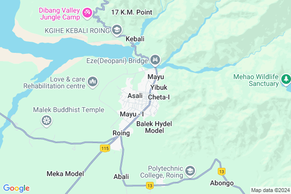
Kebali
Kebali Map
EDIT Map
Add Your House
 ..
..
Current Corona Virus Infected Patients Count in Lower Dibang Valley District
| City Name | District Name | Total Covid cases |
|---|
Locality Name :
Kebali
( केबली )
Tehsil Name : Roing
District : Lower Dibang Valley
State : Arunachal Pradesh
Language : English and Adi & Idu, Endangered, Sino-tibetan
Current Time 10:13 AM
Date: Wednesday , Feb 05,2025 (IST)
Time zone: IST (UTC+5:30)
Telephone Code / Std Code: 03803
Assembly constituency : Roing assembly constituency
Assembly MLA : Mutchu Mithi
Lok Sabha constituency : parliamentary constituency
Parliament MP :
Serpanch Name :
Kebali Live Weather
Temperature: 24.8 °C
broken clouds
Humidity: 30%
Wind : 2.2 mt/sec towards SW
StationName : "Tezu"
observed on 1 Mins Back
Temperature: 24.8 °C
broken clouds
Humidity: 30%
Wind : 2.2 mt/sec towards SW
StationName : "Tezu"
observed on 1 Mins Back
Kebali Weather Forecast for Next 5 days
06-02-2025
18.9°C to 26.2°C
broken clouds, scattered clouds, overcast clouds, light rain
18.9°C to 26.2°C
broken clouds, scattered clouds, overcast clouds, light rain
07-02-2025
16.7°C to 24.5°C
light rain, overcast clouds
16.7°C to 24.5°C
light rain, overcast clouds
08-02-2025
15.2°C to 28.3°C
light rain, overcast clouds, broken clouds, scattered clouds
15.2°C to 28.3°C
light rain, overcast clouds, broken clouds, scattered clouds
09-02-2025
15.0°C to 28.6°C
scattered clouds, broken clouds, clear sky
15.0°C to 28.6°C
scattered clouds, broken clouds, clear sky
10-02-2025
15.1°C to 28.6°C
broken clouds, scattered clouds, overcast clouds
15.1°C to 28.6°C
broken clouds, scattered clouds, overcast clouds
National Highways Reachable To Kebali
Nationa High Way :NH315A
Nationa High Way :NH13
Nationa High Way :NH315A
Nationa High Way :NH13
Rivers Near Kebali
:Mathun river :丹巴曲;丹巴江;丹巴河 :Dān bā qū;dān bā jiāng;dān bā hé Adzon river :Adzon river :丹龙曲 :dānlóng qǔ
Dri river :Dri river :德利河
:Mathun river :丹巴曲;丹巴江;丹巴河 :Dān bā qū;dān bā jiāng;dān bā hé Adzon river :Adzon river :丹龙曲 :dānlóng qǔ
Dri river :Dri river :德利河
About Kebali
Correct below Info and add more info about KebaliKebali is a Village in Roing Tehsil in Lower Dibang Valley District of Arunachal Pradesh State, India. It is located 0 KM towards North from District head quarters Roing. 282 KM from State capital Itanagar
Kebali is surrounded by Lower Dibang Valley Tehsil towards North , Meka Tehsil towards South , Koronu Tehsil towards South , Iduli Tehsil towards South .
Pasighat , Tinsukia , Digboi , Margherita are the near by Cities to Kebali.
Demographics of Kebali
English is the Local Language here.Politics in Kebali
N.A , National People s Party , AITC , BJP , INC are the major political parties in this area.Polling Stations /Booths near Kebali
1)Kendriya Vidyalaya Building Roing2)Govt Pry School Building Kebali
3)Govt. Sec. School Building (west Wing) Mayu
4)Govt Primary School Building Ezengo
5)Govt.hr Sec
HOW TO REACH Kebali
By Rail
There is no railway station near to Kebali in less than 10 km.Pincodes near Kebali
792110 ( Roing ) , 792111 ( Sunpura ) , 792001 ( Tezu )Colleges near Kebali
Indira Gandhi Government College,tezu
Address :
Schools in Kebali
Govt.primary School, Kebali
Address : kebali , roing , lower dibang valley , Arunachal Pradesh . PIN- 792110 , Post - Roing
Govt Health Centers near Kebali
1) SC New Anaya , SC New Anaya , SC New Anaya ,2) SC Arzoo , SC Arzoo , ,
3) SC Mipi , SC Mipi , SC Mipi ,
Petrol Bunks in Kebali,Roing
Kabang Gomno Filling Station
Lower Dibang Valleys;; Meka Model; Arunachal Pradesh; India
4.7 KM distance Detail
more ..
Colleges in Kebali,Roing
Government Polytechnic Roing
Po Roing;Dibang Valley; Roing; Arunachal Pradesh 792110; India
0.5 KM distance Detail
more ..
Schools in Kebali,Roing
E MAX COMPUTER EDUCATION CENTRE; MAYU-I
Mayu - I; Arunachal Pradesh 792110; India
0.2 KM distance Detail
Super Markets in Kebali,Roing
M/s Dibang Enterprises Roing
M/s Dibang Enterprises;; Roing; Arunachal Pradesh 792110; India
0.5 KM distance Detail
Local Parks in Kebali,Roing
Police Stations near Kebali,Roing
Police Station Roing
Nehru Outer Ring Road; Roing; Arunachal Pradesh 792110; India
0.4 KM distance Detail
About Kebali &
History
How to reach Kebali
Tourist Places Near By Kebali
Schools in Kebali
Colleges in Kebali
Temperature & weather of Kebali
places in Kebali
Kebali photos
More Information
How to reach Kebali
Tourist Places Near By Kebali
Schools in Kebali
Colleges in Kebali
Temperature & weather of Kebali
places in Kebali
Kebali photos
More Information
Village Talk
Post News or Events about this Village
Near Cities
Pasighat 56 KM near
Tinsukia 96 KM near
Digboi 99 KM near
Margherita 107 KM near
Pasighat 56 KM near
Tinsukia 96 KM near
Digboi 99 KM near
Margherita 107 KM near
Near By Taluks
Roing 0 KM near
Lower Dibang Valley 0 KM near
Meka 3 KM near
Koronu 13 KM near
Roing 0 KM near
Lower Dibang Valley 0 KM near
Meka 3 KM near
Koronu 13 KM near
Near By Air Ports
Chabua Airport 121 KM near
Lilabari Airport 220 KM near
Rowriah Airport 253 KM near
Dimapur Airport 363 KM near
Chabua Airport 121 KM near
Lilabari Airport 220 KM near
Rowriah Airport 253 KM near
Dimapur Airport 363 KM near
Near By Tourist Places
Roing 0 KM near
Mayudia 13 KM near
Tezu(Parasuramkunda) 45 KM near
Daying Ering Wildlife Sanctuary 45 KM near
Pasighat 59 KM near
Roing 0 KM near
Mayudia 13 KM near
Tezu(Parasuramkunda) 45 KM near
Daying Ering Wildlife Sanctuary 45 KM near
Pasighat 59 KM near
Near By Districts
Lower Dibang Valley 0 KM near
Lohit 45 KM near
East Siang 74 KM near
Dibang Valley 82 KM near
Lower Dibang Valley 0 KM near
Lohit 45 KM near
East Siang 74 KM near
Dibang Valley 82 KM near
Near By RailWay Station
New Tinsukia Junction Rail Way Station 99 KM near
Naharkatiya Rail Way Station 119 KM near
New Tinsukia Junction Rail Way Station 99 KM near
Naharkatiya Rail Way Station 119 KM near