| Home | City Bus | Maps | Villages | Cities | Rail | Tourist Places | School | College | Pin Codes | Corona Cases Count |
| Distance Calculator Bus Services IFSC Codes Trace Mobile Number Weather Search Place Trace IP Available Cash ATM/Banks Locate Polling Booth Report an Error contact People |
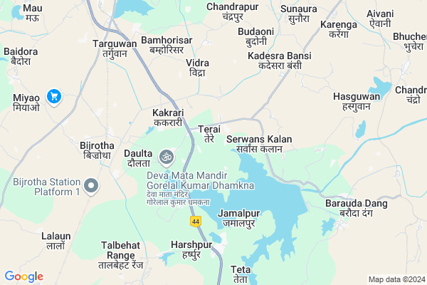
Terai
Terai Map
EDIT Map
Add Your House
 ..
..
Current Corona Virus Infected Patients Count in Lalitpur District
| City Name | District Name | Total Covid cases |
|---|
Locality Name :
Terai
( तेरे )
Block Name : Talbehat
District : Lalitpur
State : Uttar Pradesh
Division : Jhansi
Language : Hindi and Urdu
Current Time 10:57 AM
Date: Tuesday , Apr 29,2025 (IST)
Time zone: IST (UTC+5:30)
Elevation / Altitude: 353 meters. Above Seal level
Telephone Code / Std Code: 05664
Assembly constituency : Lalitpur assembly constituency
Assembly MLA : Ramratan Kushwaha
Lok Sabha constituency : Jhansi parliamentary constituency
Parliament MP : Anurag Sharma
Serpanch Name :
Pin Code : 284126
Post Office Name : Talbehat
Commodities Prices : Lalitpur Market / Mandi
Terai Live Weather
Temperature: 37.5 °C
clear sky
Humidity: 11%
Wind : 1.31 mt/sec towards SW
StationName : "TÄ\u0081lbahat"
observed on 21 Mins Back
Temperature: 37.5 °C
clear sky
Humidity: 11%
Wind : 1.31 mt/sec towards SW
StationName : "TÄ\u0081lbahat"
observed on 21 Mins Back
Terai Weather Forecast for Next 5 days
30-04-2025
29.7°C to 42.0°C
clear sky
29.7°C to 42.0°C
clear sky
01-05-2025
28.1°C to 42.1°C
clear sky
28.1°C to 42.1°C
clear sky
02-05-2025
29.0°C to 43.5°C
clear sky, few clouds
29.0°C to 43.5°C
clear sky, few clouds
03-05-2025
29.6°C to 44.3°C
clear sky, few clouds, scattered clouds, light rain
29.6°C to 44.3°C
clear sky, few clouds, scattered clouds, light rain
04-05-2025
29.9°C to 41.6°C
scattered clouds, overcast clouds, broken clouds
29.9°C to 41.6°C
scattered clouds, overcast clouds, broken clouds
Rivers Near Terai
Betwa
Betwa
About Terai
Correct below Info and add more info about TeraiTerai is a Village in Talbehat Block in Lalitpur District of Uttar Pradesh State, India. It belongs to Jhansi Division . It is located 38 KM towards North from District head quarters Lalitpur. 5 KM from Talbehat. 377 KM from State capital Lucknow
Terai Pin code is 284126 and postal head office is Talbehat .
Bari Khurd ( 4 KM ) , Rampur ( 4 KM ) , Jamalpur ( 5 KM ) , Udguwan ( 5 KM ) , Kadesra Bansi ( 5 KM ) are the nearby Villages to Terai. Terai is surrounded by Jakhaura Block towards South , Bar Block towards South , Lalitpur Block towards South , Prithvipur Block towards East .
Lalitpur , Prithvipur , Tikamgarh , Jhansi are the near by Cities to Terai.
Terai 2011 Census Details
Terai Local Language is Hindi. Terai Village Total population is 3208 and number of houses are 597. Female Population is 47.5%. Village literacy rate is 51.0% and the Female Literacy rate is 18.1%.
Population
| Census Parameter | Census Data |
| Total Population | 3208 |
| Total No of Houses | 597 |
| Female Population % | 47.5 % ( 1523) |
| Total Literacy rate % | 51.0 % ( 1636) |
| Female Literacy rate | 18.1 % ( 581) |
| Scheduled Tribes Population % | 0.7 % ( 21) |
| Scheduled Caste Population % | 14.2 % ( 455) |
| Working Population % | 32.4 % |
| Child(0 -6) Population by 2011 | 555 |
| Girl Child(0 -6) Population % by 2011 | 48.5 % ( 269) |
Terai Census More Deatils.
Politics in Terai
SP , SWP , BSP , INC are the major political parties in this area.Polling Stations /Booths near Terai
1)Inter College Tulsi Bhawan Bansi2)J.h. School South Part Serwaskalan
3)J.h.school Khandi
4)Primary School Devgrh Bhilonisuba
5)Primary School Hasarkalankhurd
HOW TO REACH Terai
By Rail
Doulta Rail Way Station , Bijrotha Rail Way Station are the very nearby railway stations to Terai.Colleges near Terai
Sree Marden Shingh Inter Collage Talbehat
Address :
Schools in Terai
Jhs Terai Phatak
Address : terai , talbehat , lalitpur , Uttar Pradesh . PIN- 284126 , Post - Talbehat
Govt Health Centers near Terai
1) Barodadong , subcentre Baroda dang , ahead 500 metres from new mandi on Paron to baroda dang road , on Road2) PPC Talbehat , PPC Talbehat , Talbehat , infront of Tehsheel
3) Khandi , SubCentre Khandi , ,
Hospitals in Terai,Talbehat
Dr.Mahendra Bundela
Shahjad Dam Rd; Barauda Dang; Uttar Pradesh 284123; India
8.4 KM distance Detail
more ..
Colleges in Terai,Talbehat
Rajarshi Purushottam Das Tandon Govt. Degree College
Talbehat; Lalitpur; Uttar Pradesh 284126; India
7.8 KM distance Detail
Shri Mardan Singh Inter College Talbehat श्री मर्दन सिंह इंटर कॉलेज तालबेहट
Talbahat; Uttar Pradesh 284126; India
10.7 KM distance Detail
Jmk Institute Of Skill Development Talbehat
Ramlila Maidan Main Road; Talbehat; Uttar Pradesh; India
10.9 KM distance Detail
Global Institute Of Technical Education.
Station Rd; Talbehat; Uttar Pradesh 284126; India
10.9 KM distance Detail
more ..
Local Parks in Terai,Talbehat
Soni Marriage Garden (Ashok Soni) Jakhaura
Jakhora; Uttar Pradesh 284124; India
18.8 KM distance Detail
Police Stations near Terai,Talbehat
Talbehat Police Station कोतवाली तालबेहट
Talbahat; Uttar Pradesh 284126; India
10.5 KM distance Detail
About Terai &
History
How to reach Terai
Tourist Places Near By Terai
Schools in Terai
Colleges in Terai
Temperature & weather of Terai
places in Terai
Terai photos
More Information
How to reach Terai
Tourist Places Near By Terai
Schools in Terai
Colleges in Terai
Temperature & weather of Terai
places in Terai
Terai photos
More Information
Village Talk
Post News or Events about this Village
Near Cities
Lalitpur 36 KM near
Prithvipur 43 KM near
Tikamgarh 48 KM near
Jhansi 60 KM near
Lalitpur 36 KM near
Prithvipur 43 KM near
Tikamgarh 48 KM near
Jhansi 60 KM near
Near By Taluks
Talbehat 5 KM near
Jakhaura 24 KM near
Bar 26 KM near
Lalitpur 36 KM near
Talbehat 5 KM near
Jakhaura 24 KM near
Bar 26 KM near
Lalitpur 36 KM near
Near By Air Ports
Khajuraho Airport 163 KM near
Gwalior Airport 167 KM near
Bhopal Airport 246 KM near
Kheria Airport 278 KM near
Khajuraho Airport 163 KM near
Gwalior Airport 167 KM near
Bhopal Airport 246 KM near
Kheria Airport 278 KM near
Near By Tourist Places
Chanderi 50 KM near
Orchha 50 KM near
Jhansi 60 KM near
Deogarh 61 KM near
Datia 87 KM near
Chanderi 50 KM near
Orchha 50 KM near
Jhansi 60 KM near
Deogarh 61 KM near
Datia 87 KM near
Near By Districts
Lalitpur 36 KM near
Tikamgarh 49 KM near
Jhansi 60 KM near
Datia 89 KM near
Lalitpur 36 KM near
Tikamgarh 49 KM near
Jhansi 60 KM near
Datia 89 KM near
Near By RailWay Station
Doulta Rail Way Station 7.3 KM near
Bijrotha Rail Way Station 7.6 KM near
Talbahat Rail Way Station 11 KM near
Babina Rail Way Station 33 KM near
Doulta Rail Way Station 7.3 KM near
Bijrotha Rail Way Station 7.6 KM near
Talbahat Rail Way Station 11 KM near
Babina Rail Way Station 33 KM near