| Home | City Bus | Maps | Villages | Cities | Rail | Tourist Places | School | College | Pin Codes | Corona Cases Count |
| Distance Calculator Bus Services IFSC Codes Trace Mobile Number Weather Search Place Trace IP Available Cash ATM/Banks Locate Polling Booth Report an Error contact People |
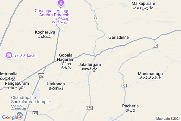
Jaladurgam
Jaladurgam Map
EDIT Map
Add Your House
 ..
..
Current Corona Virus Infected Patients Count in Kurnool District
| City Name | District Name | Total Covid cases |
|---|---|---|
| Kurnool District | Kurnool | 191 |
| Kurnool | Kurnool | 16 |
| Nandyal | Kurnool | 8 |
| Nandyala | Kurnool | 6 |
| Ganigali Street | Kurnool | 4 |
| Maddur | Kurnool | 3 |
| Banaganapalli | Kurnool | 3 |
| Habeeb Mubarak Nagar | Kurnool | 3 |
| Gani Gali Street | Kurnool | 2 |
| - | Kurnool | 2 |
| Gadivemula | Kurnool | 2 |
| Khadakpura | Kurnool | 1 |
| Nandyal Town | Kurnool | 1 |
| Bedamcherla | Kurnool | 1 |
| Nadyal | Kurnool | 1 |
| Osmania College Road | Kurnool | 1 |
| Chagala Marri | Kurnool | 1 |
| Sangaih Pet | Kurnool | 1 |
| Atmukur | Kurnool | 1 |
| Gonampalle | Kurnool | 1 |
| Budhavur Petta | Kurnool | 1 |
| Atmakur | Kurnool | 1 |
| Pedda | Kurnool | 1 |
| Chittari | Kurnool | 1 |
| Revenue Colony | Kurnool | 1 |
| Ayyaluru | Kurnool | 1 |
| Kodumur | Kurnool | 1 |
| Prakasam Nagar | Kurnool | 1 |
| Kotaveedhi | Kurnool | 1 |
| Budhawarapetta | Kurnool | 1 |
| Chandabada | Kurnool | 1 |
| KVR Garden | Kurnool | 1 |
| Banaganapalle Mandal | Kurnool | 1 |
| Nandavaram | Kurnool | 1 |
| Nandikotkur | Kurnool | 1 |
| Padidempadu | Kurnool | 1 |
| A-park road | Kurnool | 1 |
| Devanagar | Kurnool | 1 |
| Athmakur | Kurnool | 1 |
| Kodaru | Kurnool | 1 |
| Ganigalli | Kurnool | 1 |
| Islam petta, Atmakur | Kurnool | 1 |
| Nagappa Street | Kurnool | 1 |
| Panyam | Kurnool | 1 |
| Shalisaheb Street | Kurnool | 1 |
| Malyala Village | Kurnool | 1 |
| Nandyala Mandal | Kurnool | 1 |
| SriLakshmi Nagar | Kurnool | 1 |
| Budhavarpeta | Kurnool | 1 |
| Narsingh Rao Pet | Kurnool | 1 |
Locality Name :
Jaladurgam
( జాలదుర్గం )
Mandal Name : Peapully
District : Kurnool
State : Andhra Pradesh
Region : Rayalaseema
Language : Telugu and Urdu
Current Time 05:36 AM
Date: Saturday , Apr 26,2025 (IST)
Time zone: IST (UTC+5:30)
Elevation / Altitude: 334 meters. Above Seal level
Telephone Code / Std Code: 08552
Assembly constituency : assembly constituency
Assembly MLA : Buggana Raja Reddy
Lok Sabha constituency : parliamentary constituency
Parliament MP : POCHA . BRAHMANANDA REDDY
Serpanch Name :
Pin Code : 518220
Post Office Name : Jaladurgam
Commodities Prices : Dhone Market / Mandi
Jaladurgam Live Weather
Temperature: 27.0 °C
clear sky
Humidity: 69%
Wind : 3.59 mt/sec towards SE
StationName : "RÄ\u0081mÄ\u0081puram"
observed on Now
Temperature: 27.0 °C
clear sky
Humidity: 69%
Wind : 3.59 mt/sec towards SE
StationName : "RÄ\u0081mÄ\u0081puram"
observed on Now
Jaladurgam Weather Forecast for Next 5 days
27-04-2025
28.8°C to 39.5°C
clear sky, few clouds, broken clouds, overcast clouds
28.8°C to 39.5°C
clear sky, few clouds, broken clouds, overcast clouds
28-04-2025
28.5°C to 38.9°C
overcast clouds, broken clouds
28.5°C to 38.9°C
overcast clouds, broken clouds
29-04-2025
27.6°C to 39.4°C
scattered clouds, clear sky, overcast clouds, broken clouds
27.6°C to 39.4°C
scattered clouds, clear sky, overcast clouds, broken clouds
30-04-2025
29.3°C to 40.7°C
scattered clouds, clear sky, broken clouds, few clouds
29.3°C to 40.7°C
scattered clouds, clear sky, broken clouds, few clouds
01-05-2025
28.8°C to 40.4°C
scattered clouds, clear sky, broken clouds, overcast clouds
28.8°C to 40.4°C
scattered clouds, clear sky, broken clouds, overcast clouds
Edit below overview about Jaladurgam
Edit below overview about Jaladurgam
OverView of Jaladurgam
near by railway station is Dhone which is 12 km from. this village is mainly depend on cultivation, major crops is rice, groundnut, onion, greenchilli.Edit below overview about Jaladurgam
National Highways Reachable To Jaladurgam
Nationa High Way :NH 150
Nationa High Way :NH167
Nationa High Way :NH 150
Nationa High Way :NH167
Rivers Near Jaladurgam
Puli Vanka
Handri :Handri :ಹಂದ್ರಿ :హంద్రి
Puli Vanka
Handri :Handri :ಹಂದ್ರಿ :హంద్రి
About Jaladurgam
Jaladurgam is a Village in Peapully Mandal in Kurnool District of Andhra Pradesh State, India. It belongs to Rayalaseema region . It is located 71 KM towards South from District head quarters Kurnool. 12 KM from Peapully. 282 KM from State capital Hyderabad
Jaladurgam Pin code is 518220 and postal head office is Jaladurgam .
Madhavaram ( 7 KM ) , Kocheruvu ( 7 KM ) , Munimadugu ( 8 KM ) , Bavipalli ( 8 KM ) , Kamalapuram ( 9 KM ) are the nearby Villages to Jaladurgam. Jaladurgam is surrounded by Dhone Alias Dronachalam Mandal towards North , Yadiki Mandal towards South , Bethamcherla Mandal towards East , Owk Mandal towards East .
Bethamcherla , Gooty , Banganapalle , Tadpatri are the near by Cities to Jaladurgam.
This Place is in the border of the Kurnool District and Anantapur District. Anantapur District Gooty is west towards this place .
Jaladurgam 2011 Census Details
Jaladurgam Local Language is Telugu. Jaladurgam Village Total population is 8322 and number of houses are 1924. Female Population is 48.3%. Village literacy rate is 51.5% and the Female Literacy rate is 19.3%.
Population
| Census Parameter | Census Data |
| Total Population | 8322 |
| Total No of Houses | 1924 |
| Female Population % | 48.3 % ( 4017) |
| Total Literacy rate % | 51.5 % ( 4284) |
| Female Literacy rate | 19.3 % ( 1603) |
| Scheduled Tribes Population % | 1.5 % ( 124) |
| Scheduled Caste Population % | 16.0 % ( 1333) |
| Working Population % | 50.8 % |
| Child(0 -6) Population by 2011 | 948 |
| Girl Child(0 -6) Population % by 2011 | 49.3 % ( 467) |
Jaladurgam Census More Deatils.
HOW TO REACH Jaladurgam
By Road
Kurnool is the Nearest Town to Jaladurgam. Kurnool is 71 km from Jaladurgam. Road connectivity is there from Kurnool to Jaladurgam.By Rail
There is no railway station near to Jaladurgam in less than 10 km. How ever there are railway Stations from Near By town Kurnool. are the railway Stations near to Kurnool. You can reach from Kurnool to Jaladurgam by road after .By Bus
Dhone APSRTC Bus Station , Pyapili APSRTC Bus Station , Owk APSRTC Bus Station are the nearby by Bus Stations to Jaladurgam .APSRTC runs Number of busses from major cities to here.Colleges near Jaladurgam
Sri Venkateswara Degree College
Address : College Road Peapully
Shanthi Junior College
Address :
Govt Junior College Peapully
Address : Govt Junior College Peapully
Schools in Jaladurgam
Zphs Jaladurgam
Address : jaladurgam , peapully , kurnool , Andhra Pradesh . PIN- 518220 , Post - Jaladurgam
Global Concept E.m T M S
Address : jaladurgam , peapully , kurnool , Andhra Pradesh . PIN- 518221 , Post - Peapully
Mpups Ramakrishnapuram
Address : jaladurgam , peapully , kurnool , Andhra Pradesh . PIN- 518220 , Post - Jaladurgam
Mpups Utakonda
Address : jaladurgam , peapully , kurnool , Andhra Pradesh . PIN- 518220 , Post - Jaladurgam
Govt Health Centers near Jaladurgam
1) KOTCHERLAKOTA , , SC PALEM ,KOCHARLAKOTA , NEAR A.W.W CENTRE2) Venkatapuram , 2-51A , BC Street , Kambalapadu Road
3) Devarabanda , 26-Feb , Main Road , Near MPUP School
Sub Villages in Jaladurgam
Hospitals in Jaladurgam,Peapully
Primary Health Centre; (PHC) Jaladurgam
Jaladurgam; Andhra Pradesh 518220; India
0.6 KM distance Detail
more ..
Petrol Bunks in Jaladurgam,Peapully
HP PETROL PUMP - SRI UMA MAHESWARA F/S GARLADINNE
HPC Dealer Survey NO.552/A; Garladinne Village Banaganpalle-peapally Road; Andhra Pradesh 518123; India
7.0 KM distance Detail
more ..
Schools in Jaladurgam,Peapully
VIVEKANANDA COMPUTER TECHNOLOGY
NO:57/54; KAMARAJ STEET; SHEBKAMM; 632 008 TAMILANDU; Vellore; India
7.0 KM distance Detail
Electronic Shops in Jaladurgam,Peapully
sudha Cellpoint
Bethamcherla Rd; Kothapeta; Dhone; Andhra Pradesh 518222; India
13.8 KM distance Detail
Super Markets in Jaladurgam,Peapully
kamisetty Nagaraju kiranam general store
Dhone; Andhra Pradesh 518222; India
14.1 KM distance Detail
Al-Madina General Store; Dhone
Auto Nagar; Dhone; Andhra Pradesh 518222; India
14.2 KM distance Detail
Local Parks in Jaladurgam,Peapully
Arigela Anji mango gardens
Enugumarri; Mettupalle; Andhra Pradesh 518221; India
14.3 KM distance Detail
Arigela Venkataramudu Mango Gardens
Enugumarri; Mettupalle; Andhra Pradesh 518221; India
14.3 KM distance Detail
Governement Offices near Jaladurgam,Peapully
Gosanipalli;Dhone;Andhra pradesh
Gosanipalli;; Dhone; Andhra Pradesh 518222; India
8.7 KM distance Detail
MeeSeva Center
Malkapuram; Dhone(M); Bethamcherla Rd; Andhra Pradesh 518222; India
13.2 KM distance Detail
About Jaladurgam &
History
How to reach Jaladurgam
Tourist Places Near By Jaladurgam
Schools in Jaladurgam
Colleges in Jaladurgam
Temperature & weather of Jaladurgam
places in Jaladurgam
Jaladurgam photos
More Information
How to reach Jaladurgam
Tourist Places Near By Jaladurgam
Schools in Jaladurgam
Colleges in Jaladurgam
Temperature & weather of Jaladurgam
places in Jaladurgam
Jaladurgam photos
More Information
Village Talk
Post News or Events about this Village
Near Cities
Bethamcherla 35 KM near
Gooty 38 KM near
Banganapalle 40 KM near
Tadpatri 48 KM near
Bethamcherla 35 KM near
Gooty 38 KM near
Banganapalle 40 KM near
Tadpatri 48 KM near
Near By Taluks
Peapully 11 KM near
Dhone Alias Dronachalam 14 KM near
Bethamcherla 29 KM near
Yadiki 29 KM near
Peapully 11 KM near
Dhone Alias Dronachalam 14 KM near
Bethamcherla 29 KM near
Yadiki 29 KM near
Near By Air Ports
Rajiv Gandhi International Airport 250 KM near
Bengaluru International Airport 261 KM near
Tirupati Airport 285 KM near
Hubli Airport 338 KM near
Rajiv Gandhi International Airport 250 KM near
Bengaluru International Airport 261 KM near
Tirupati Airport 285 KM near
Hubli Airport 338 KM near
Near By Tourist Places
Kurnool 67 KM near
Mantralayam 99 KM near
Puttaparthi 140 KM near
Kadapa 151 KM near
Srisailam 151 KM near
Kurnool 67 KM near
Mantralayam 99 KM near
Puttaparthi 140 KM near
Kadapa 151 KM near
Srisailam 151 KM near
Near By Districts
Kurnool 67 KM near
Anantapur 83 KM near
Bellary 119 KM near
Raichur 131 KM near
Kurnool 67 KM near
Anantapur 83 KM near
Bellary 119 KM near
Raichur 131 KM near
Near By RailWay Station
Dhone Junction Rail Way Station 13 KM near
Betamcherla Rail Way Station 35 KM near
Dhone Junction Rail Way Station 13 KM near
Betamcherla Rail Way Station 35 KM near