| Home | City Bus | Maps | Villages | Cities | Rail | Tourist Places | School | College | Pin Codes | Corona Cases Count |
| Distance Calculator Bus Services IFSC Codes Trace Mobile Number Weather Search Place Trace IP Available Cash ATM/Banks Locate Polling Booth Report an Error contact People |
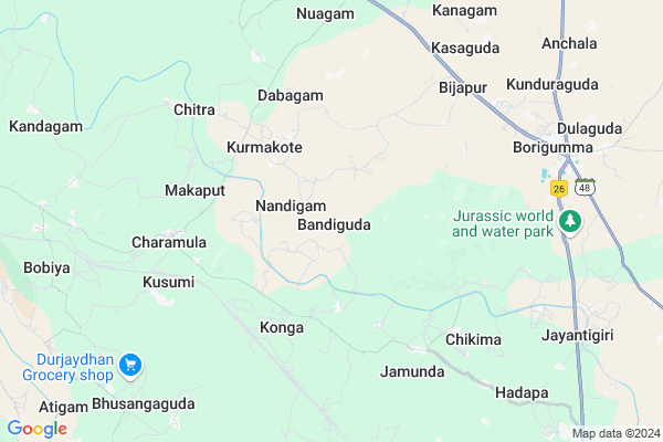
Bandiguda Map
EDIT Map
Add Your House
 ..
..
Current Corona Virus Infected Patients Count in Koraput District
| City Name | District Name | Total Covid cases |
|---|
Locality Name :
Bandiguda
( ବଂଦୀଗୁଡା )
Tehsil Name : Borigumma
District : Koraput
State : Odisha
Language : Oriya and Hindi
Current Time 08:16 PM
Date: Tuesday , Apr 29,2025 (IST)
Time zone: IST (UTC+5:30)
Elevation / Altitude: 559 meters. Above Seal level
Telephone Code / Std Code: 06860
Assembly constituency : Kotpad assembly constituency
Assembly MLA : chandra sekhar majhi
Lok Sabha constituency : Nabarangpur parliamentary constituency
Parliament MP : RAMESH CHANDRA MAJHI
Serpanch Name :
Pin Code : 764055
Post Office Name : Ambaguda
Commodities Prices : Nawarangpur Market / Mandi
Bandiguda Live Weather
Temperature: 31.2 °C
broken clouds
Humidity: 25%
Wind : 4.34 mt/sec towards N
StationName : "Jeypore"
observed on 1 Hours Back
Temperature: 31.2 °C
broken clouds
Humidity: 25%
Wind : 4.34 mt/sec towards N
StationName : "Jeypore"
observed on 1 Hours Back
Bandiguda Weather Forecast for Next 5 days
30-04-2025
24.9°C to 29.6°C
light rain, scattered clouds, clear sky
24.9°C to 29.6°C
light rain, scattered clouds, clear sky
01-05-2025
23.9°C to 36.5°C
clear sky, few clouds, scattered clouds
23.9°C to 36.5°C
clear sky, few clouds, scattered clouds
02-05-2025
23.3°C to 38.8°C
clear sky, few clouds, light rain, scattered clouds
23.3°C to 38.8°C
clear sky, few clouds, light rain, scattered clouds
03-05-2025
24.0°C to 37.8°C
few clouds, clear sky, scattered clouds, light rain, broken clouds
24.0°C to 37.8°C
few clouds, clear sky, scattered clouds, light rain, broken clouds
04-05-2025
24.4°C to 38.3°C
scattered clouds, clear sky, few clouds, light rain, overcast clouds
24.4°C to 38.3°C
scattered clouds, clear sky, few clouds, light rain, overcast clouds
Rivers Near Bandiguda
Bhaskel
Chhabili
Bhaskel
Chhabili
About Bandiguda
Correct below Info and add more info about BandigudaBandiguda is a small Village/hamlet in Borigumma Tehsil in Koraput District of Odisha State, India. It is located 40 KM towards west from District head quarters Koraput. 16 KM from Borigumma. 442 KM from State capital Bhubaneswar
Bandiguda Pin code is 764055 and postal head office is Ambaguda .
Kusumi ( 6 KM ) , Chitra ( 6 KM ) , Bijapur ( 7 KM ) , Borigumma ( 8 KM ) , Bhusangaguda ( 10 KM ) are the nearby Villages to Bandiguda. Bandiguda is surrounded by Kundura Tehsil towards South , Kotpad Tehsil towards west , Jeypore Tehsil towards South , Nabarangpur Tehsil towards North .
Jeypur , Nabarangapur , Koraput , Jagdalpur are the near by Cities to Bandiguda.
Bandiguda 2011 Census Details
Bandiguda Local Language is Oriya. Bandiguda Village Total population is 1479 and number of houses are 362. Female Population is 50.2%. Village literacy rate is 31.2% and the Female Literacy rate is 11.0%.
Population
| Census Parameter | Census Data |
| Total Population | 1479 |
| Total No of Houses | 362 |
| Female Population % | 50.2 % ( 742) |
| Total Literacy rate % | 31.2 % ( 461) |
| Female Literacy rate | 11.0 % ( 163) |
| Scheduled Tribes Population % | 82.4 % ( 1218) |
| Scheduled Caste Population % | 14.7 % ( 217) |
| Working Population % | 53.2 % |
| Child(0 -6) Population by 2011 | 307 |
| Girl Child(0 -6) Population % by 2011 | 52.1 % ( 160) |
Bandiguda Census More Deatils.
Politics in Bandiguda
INC is the major political party in this area.Polling Stations /Booths near Bandiguda
1)Primary School Bandhabeda2)Primary School Bhusangaguda
3)Primary School Makaput
4)U.p.school Kamara
5)Panasput Pry.school
HOW TO REACH Bandiguda
By Rail
Khadapa Rail Way Station , Charamula Kusum Rail Way Station are the very nearby railway stations to Bandiguda.Colleges near Bandiguda
Borigumma Mahavidyalaya , Borigumma
Address :
Schools near Bandiguda
Upper Primary School, Badadubuli
Address : Badadubuli
Govt High School,kumuli
Address : AT/PO- KUMULI,VIA- B.SINGPUR,DIST- KORAPUT
Govt High School B.singpur
Address : At- B.singpur
Govt S.s.d High School Gumuda ..up Sebasram Bidylaya Gumuda
Address :
Govt Health Centers near Bandiguda
1) Kamta , , KUMULI ,2) Puruna Borigumma , , BORIGUMMA SECTOR , SRI BALAJI TEMPLE
3) Kumuliput , , Kumuliput ,
Colleges in Bandiguda,Borigumma
Nicet Computer Education Center
NH43; Narasimha Nagar; Borigumma; Odisha 764056; India
9.3 KM distance Detail
Jeypore College of Pharmacy
Rondapalli; Koraput; Jeypore; Odisha 764002; India
16.3 KM distance Detail
more ..
Schools in Bandiguda,Borigumma
Prakalpa Upper Primary School
Bandaguda; Koraput; NH-43; Jeypore Vizianagaram Road; Koraput; Koraput; Odisha 764058; India
7.5 KM distance Detail
About Bandiguda &
History
How to reach Bandiguda
Tourist Places Near By Bandiguda
Schools in Bandiguda
Colleges in Bandiguda
Temperature & weather of Bandiguda
places in Bandiguda
Bandiguda photos
More Information
How to reach Bandiguda
Tourist Places Near By Bandiguda
Schools in Bandiguda
Colleges in Bandiguda
Temperature & weather of Bandiguda
places in Bandiguda
Bandiguda photos
More Information
Village Talk
Post News or Events about this Village
Near Cities
Jeypur 23 KM near
Nabarangapur 26 KM near
Koraput 37 KM near
Jagdalpur 52 KM near
Jeypur 23 KM near
Nabarangapur 26 KM near
Koraput 37 KM near
Jagdalpur 52 KM near
Near By Taluks
Borigumma 15 KM near
Kundura 17 KM near
Kotpad 17 KM near
Jeypore 21 KM near
Borigumma 15 KM near
Kundura 17 KM near
Kotpad 17 KM near
Jeypore 21 KM near
Near By Air Ports
Vishakhapatnam Airport 184 KM near
Rajahmundry Airport 251 KM near
Raipur Airport 281 KM near
Vijayawada Airport 369 KM near
Vishakhapatnam Airport 184 KM near
Rajahmundry Airport 251 KM near
Raipur Airport 281 KM near
Vijayawada Airport 369 KM near
Near By Tourist Places
Jeypore 22 KM near
Jagdalpur 53 KM near
Bastar 60 KM near
Araku Valley 97 KM near
Ananthagiri 98 KM near
Jeypore 22 KM near
Jagdalpur 53 KM near
Bastar 60 KM near
Araku Valley 97 KM near
Ananthagiri 98 KM near
Near By Districts
Nabarangpur 26 KM near
Koraput 38 KM near
Bastar 68 KM near
Malkangiri 108 KM near
Nabarangpur 26 KM near
Koraput 38 KM near
Bastar 68 KM near
Malkangiri 108 KM near
Near By RailWay Station
Khadapa Rail Way Station 5.2 KM near
Charamula Kusum Rail Way Station 8.0 KM near
Koraput Junction Rail Way Station 40 KM near
Rayagada Rail Way Station 110 KM near
Khadapa Rail Way Station 5.2 KM near
Charamula Kusum Rail Way Station 8.0 KM near
Koraput Junction Rail Way Station 40 KM near
Rayagada Rail Way Station 110 KM near