| Home | City Bus | Maps | Villages | Cities | Rail | Tourist Places | School | College | Pin Codes | Corona Cases Count |
| Distance Calculator Bus Services IFSC Codes Trace Mobile Number Weather Search Place Trace IP Available Cash ATM/Banks Locate Polling Booth Report an Error contact People |
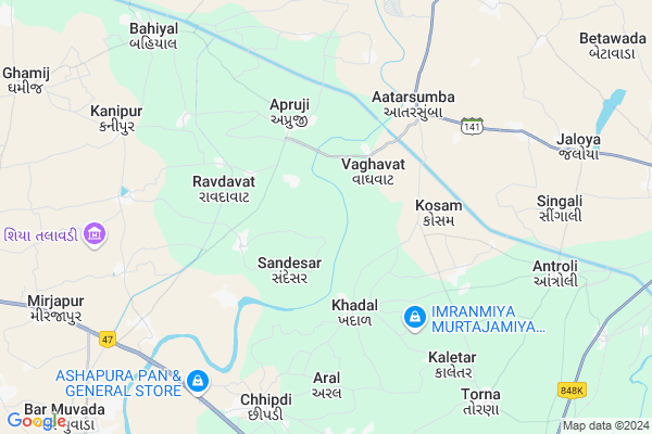
Chelavat Map
EDIT Map
Add Your House
 ..
..
Current Corona Virus Infected Patients Count in Kheda District
| City Name | District Name | Total Covid cases |
|---|---|---|
| Kheda District | Kheda | 6 |
Locality Name :
Chelavat
( ચેલાવત )
Taluka Name : Kathlal
District : Kheda
State : Gujarat
Language : Gujarati and Hindi
Current Time 02:17 PM
Date: Friday , Apr 25,2025 (IST)
Time zone: IST (UTC+5:30)
Elevation / Altitude: 61 meters. Above Seal level
Telephone Code / Std Code: 02691
Assembly constituency : Kapadvanj assembly constituency
Assembly MLA : Zala Rajeshkumar Maganbhai
Lok Sabha constituency : Kheda parliamentary constituency
Parliament MP : Chauhan Devusinh
Serpanch Name :
Pin Code : 387610
Post Office Name : Attarsumba
Commodities Prices : Kapadvanj Market / Mandi
Chelavat Live Weather
Temperature: 41.0 °C
clear sky
Humidity: 13%
Wind : 4.56 mt/sec towards W
StationName : "Kapadvanj"
observed on 18 Mins Back
Temperature: 41.0 °C
clear sky
Humidity: 13%
Wind : 4.56 mt/sec towards W
StationName : "Kapadvanj"
observed on 18 Mins Back
Chelavat Weather Forecast for Next 5 days
26-04-2025
28.4°C to 41.9°C
clear sky
28.4°C to 41.9°C
clear sky
27-04-2025
26.8°C to 42.8°C
clear sky
26.8°C to 42.8°C
clear sky
28-04-2025
27.0°C to 43.4°C
clear sky
27.0°C to 43.4°C
clear sky
29-04-2025
27.2°C to 44.0°C
clear sky
27.2°C to 44.0°C
clear sky
30-04-2025
27.6°C to 44.7°C
clear sky
27.6°C to 44.7°C
clear sky
National Highways Reachable To Chelavat
Nationa High Way :NH48;NH47
Nationa High Way :NH8A
Nationa High Way :NH48;NH47
Nationa High Way :NH8A
About Chelavat
Correct below Info and add more info about ChelavatChelavat is a Village in Kathlal Taluka in Kheda District of Gujarat State, India. It is located 46 KM towards North from District head quarters Kheda. 9 KM from . 43 KM from State capital Gandhinagar
Chelavat Pin code is 387610 and postal head office is Attarsumba .
Chared ( 3 KM ) , Sandesar ( 3 KM ) , Ravdavat ( 3 KM ) , Khadal ( 3 KM ) , Atarsumba ( 3 KM ) are the nearby Villages to Chelavat. Chelavat is surrounded by Kapadvanj Taluka towards East , Dehgam Taluka towards North , Mehmedabad Taluka towards South , Mahudha Taluka towards South .
Kapadvanj , Dehgam , Mehmedabad , Nadiad are the near by Cities to Chelavat.
This Place is in the border of the Kheda District and Anand District. Anand District Umreth is South towards this place .
Chelavat 2011 Census Details
Chelavat Local Language is Gujarati. Chelavat Village Total population is 1403 and number of houses are 277. Female Population is 49.9%. Village literacy rate is 66.0% and the Female Literacy rate is 26.9%.
Population
| Census Parameter | Census Data |
| Total Population | 1403 |
| Total No of Houses | 277 |
| Female Population % | 49.9 % ( 700) |
| Total Literacy rate % | 66.0 % ( 926) |
| Female Literacy rate | 26.9 % ( 377) |
| Scheduled Tribes Population % | 1.3 % ( 18) |
| Scheduled Caste Population % | 0.4 % ( 6) |
| Working Population % | 48.0 % |
| Child(0 -6) Population by 2011 | 191 |
| Girl Child(0 -6) Population % by 2011 | 50.3 % ( 96) |
Chelavat Census More Deatils.
Politics in Chelavat
Bharatiya Janata Party , BJP , INC are the major political parties in this area.Polling Stations /Booths near Chelavat
1)Chared-22)Salod
3)Sandeshar-1
4)Punadra-2
5)Ravdavat-1
HOW TO REACH Chelavat
By Rail
There is no railway station near to Chelavat in less than 10 km.Colleges near Chelavat
L.j. Institute Of Technology And Engineering
Address : Sarkhej, Ahmadabad
Schools in Chelavat
Chelavat P.s.
Address : chelavat , kathlal , kheda , Gujarat . PIN- 387610 , Post - Attarsumba
Govt Health Centers near Chelavat
1) Mudel Ratanpur , Sub Center Mudel Ratanpur , , Nr.Primary School Mudel2) Ukardina Muvada , Sub Centre Ukardina Muvada , ,
3) Antroli-1 , Sub Centre Antroli-1 , ,
Sub Villages in Chelavat
Colleges in Chelavat,Kathlal
Anupam Computer Academy & Paramedical Institute
Haldharvas Chowkdi; Gujarat 387610; India
9.7 KM distance Detail
K.P.Patel School of Management and Computer Studies
jeevanshilp Campus; Kapadvanj; 387620; India
15.6 KM distance Detail
Smt. S. K. Shah College of Education
Dakor Road; Kheda; Kapadvanj; Gujarat 387620; India
15.9 KM distance Detail
Government Polytechnic
JD TATTOO HUB; G-4; Dakor Rd; Kapadvanj; Gujarat 387620; India
16.4 KM distance Detail
more ..
About Chelavat &
History
How to reach Chelavat
Tourist Places Near By Chelavat
Schools in Chelavat
Colleges in Chelavat
Temperature & weather of Chelavat
places in Chelavat
Chelavat photos
More Information
How to reach Chelavat
Tourist Places Near By Chelavat
Schools in Chelavat
Colleges in Chelavat
Temperature & weather of Chelavat
places in Chelavat
Chelavat photos
More Information
Village Talk
Post News or Events about this Village
Near Cities
Kapadvanj 15 KM near
Dehgam 23 KM near
Mehmedabad 33 KM near
Nadiad 40 KM near
Kapadvanj 15 KM near
Dehgam 23 KM near
Mehmedabad 33 KM near
Nadiad 40 KM near
Near By Taluks
Kathlal 9 KM near
Kapadvanj 18 KM near
Dehgam 20 KM near
Mehmedabad 25 KM near
Kathlal 9 KM near
Kapadvanj 18 KM near
Dehgam 20 KM near
Mehmedabad 25 KM near
Near By Air Ports
Ahmedabad Airport 36 KM near
Vadodara Airport 91 KM near
Bhavnagar Airport 179 KM near
Dabok Airport 226 KM near
Ahmedabad Airport 36 KM near
Vadodara Airport 91 KM near
Bhavnagar Airport 179 KM near
Dabok Airport 226 KM near
Near By Tourist Places
Gandhinagar 41 KM near
Ahmedabad 42 KM near
Kheda 44 KM near
Anand 56 KM near
Sabarkantha 72 KM near
Gandhinagar 41 KM near
Ahmedabad 42 KM near
Kheda 44 KM near
Anand 56 KM near
Sabarkantha 72 KM near
Near By Districts
Ahmadabad 37 KM near
Gandhinagar 41 KM near
Kheda 44 KM near
Anand 56 KM near
Ahmadabad 37 KM near
Gandhinagar 41 KM near
Kheda 44 KM near
Anand 56 KM near
Near By RailWay Station
Mahemdavad Kheda Road Rail Way Station 33 KM near
Maninagar Rail Way Station 37 KM near
Mahemdavad Kheda Road Rail Way Station 33 KM near
Maninagar Rail Way Station 37 KM near