| Home | City Bus | Maps | Villages | Cities | Rail | Tourist Places | School | College | Pin Codes | Corona Cases Count |
| Distance Calculator Bus Services IFSC Codes Trace Mobile Number Weather Search Place Trace IP Available Cash ATM/Banks Locate Polling Booth Report an Error contact People |
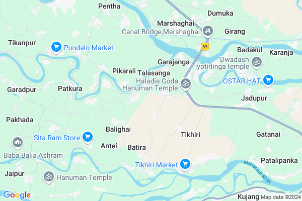
Alifa
Alifa Map
EDIT Map
Add Your House
 ..
..
Current Corona Virus Infected Patients Count in Kendrapara District
| City Name | District Name | Total Covid cases |
|---|---|---|
| Kendrapara District | Kendrapara | 2 |
Locality Name :
Alifa
( ଏଲିଫା )
Tehsil Name : Marsaghai
District : Kendrapara
State : Odisha
Language : Oriya and Hindi
Current Time 10:12 AM
Date: Wednesday , Mar 12,2025 (IST)
Time zone: IST (UTC+5:30)
Elevation / Altitude: 9 meters. Above Seal level
Telephone Code / Std Code: 06725
Assembly constituency : Mahakalapada assembly constituency
Assembly MLA : atanu sabyasachi nayak
Lok Sabha constituency : Kendrapara parliamentary constituency
Parliament MP : Anubhav Mohanty
Serpanch Name :
Commodities Prices : Kendrapara(Marshaghai) Market / Mandi
Alifa Live Weather
Temperature: 31.3 °C
clear sky
Humidity: 30%
Wind : 3.2 mt/sec towards SW
StationName : "KendrÄ\u0081parha"
observed on 47 Mins Back
Temperature: 31.3 °C
clear sky
Humidity: 30%
Wind : 3.2 mt/sec towards SW
StationName : "KendrÄ\u0081parha"
observed on 47 Mins Back
Alifa Weather Forecast for Next 5 days
13-03-2025
22.9°C to 35.5°C
clear sky
22.9°C to 35.5°C
clear sky
14-03-2025
23.4°C to 38.9°C
clear sky, scattered clouds
23.4°C to 38.9°C
clear sky, scattered clouds
15-03-2025
24.2°C to 37.3°C
few clouds, scattered clouds, clear sky
24.2°C to 37.3°C
few clouds, scattered clouds, clear sky
16-03-2025
23.8°C to 39.0°C
few clouds, clear sky, scattered clouds
23.8°C to 39.0°C
few clouds, clear sky, scattered clouds
17-03-2025
24.6°C to 39.9°C
scattered clouds, few clouds, clear sky
24.6°C to 39.9°C
scattered clouds, few clouds, clear sky
National Highways Reachable To Alifa
Nationa High Way :NH53
Nationa High Way :NH16
Nationa High Way :NH53
Nationa High Way :NH16
Rivers Near Alifa
Brahmani :Брагмані
Salandi
Brahmani :Брагмані
Salandi
About Alifa
Correct below Info and add more info about AlifaAlifa is a small Village/hamlet in Marsaghai Tehsil in Kendrapara District of Odisha State, India. It is located 17 KM towards South from District head quarters Kendrapara. 6 KM from Marsaghai. 77 KM from State capital Bhubaneswar
Parakula ( 2 KM ) , Talasanga ( 2 KM ) , Batira ( 3 KM ) , Garajanga ( 3 KM ) , Ameipal ( 4 KM ) are the nearby Villages to Alifa. Alifa is surrounded by Kujang Tehsil towards South , Garadapur Tehsil towards west , Mahakalapada Tehsil towards East , Kendrapada Tehsil towards North .
Kendrapara , Paradip , Pattamundai , Jagatsinghapur are the near by Cities to Alifa.
This Place is in the border of the Kendrapara District and Jagatsinghapur District. Jagatsinghapur District Kujang is South towards this place .
Alifa 2011 Census Details
Alifa Local Language is Oriya. Alifa Village Total population is 296 and number of houses are 76. Female Population is 50.0%. Village literacy rate is 74.3% and the Female Literacy rate is 32.8%.
Population
| Census Parameter | Census Data |
| Total Population | 296 |
| Total No of Houses | 76 |
| Female Population % | 50.0 % ( 148) |
| Total Literacy rate % | 74.3 % ( 220) |
| Female Literacy rate | 32.8 % ( 97) |
| Scheduled Tribes Population % | 0.0 % ( 0) |
| Scheduled Caste Population % | 46.3 % ( 137) |
| Working Population % | 28.7 % |
| Child(0 -6) Population by 2011 | 34 |
| Girl Child(0 -6) Population % by 2011 | 58.8 % ( 20) |
Alifa Census More Deatils.
Politics in Alifa
BJD is the major political party in this area.Polling Stations /Booths near Alifa
1)Benupal Pry School Benupal2)Tulasipur Project Ugup School
3)Suniti Ugup Suniti
4)Talasanga Nodal Up School
5)Nigamananda Up School Sanarahama
HOW TO REACH Alifa
By Rail
There is no railway station near to Alifa in less than 10 km.Pincodes near Alifa
754253 ( Bedari ) , 754213 ( Marsaghai ) , 754162 ( Kolar )Colleges near Alifa
Dayanidhi Sanskrit Degree College Potari
Address : At Potari ,po Batira Pin_ 754140
Chitrotppala Collage Akhua
Address :
Biju Pattanaik College
Address :
Schools in Alifa
Alifa Project P.s
Address : alifa , marshaghai , kendrapara , Sikkim . PIN- 754140 , Post - Rahama
Govt Health Centers near Alifa
1) Tikhiri , , Patalipank Sector , Near Tikhiri Primary School2) Jaichandrapur , , Jadupur Sector , Near Panchayat High School Jayachandrapur
3) Rajgarh , , HQ Sector , Near Rajagarh Primary School
Petrol Bunks in Alifa,Marsaghai
Sarala Filling Station Indian Oil Petrol Pump
Kendrapara; NH-5A; Chandikhol Paradeep Road; Marshaghai; Marshaghai; Odisha 754212; India
7.5 KM distance Detail
HP PETROL PUMP - BALDEVJEW FUEL CENTRE
HPC Dealer NH5A; Marshaghai Dist.; Bhubaneshwar; Odisha 754213; India
8.1 KM distance Detail
more ..
Colleges in Alifa,Marsaghai
TITC
At/Post - Garajanga Near Haladiagada; Via - Marshaghai; Dist. - Kendrapara; Garajanga; Odisha 754213; India
2.2 KM distance Detail
maa tarini maha bidyalaya ; jaychandrapur
Paradeep - Chandikhol Rd; Bauda; Odisha 754213; India
5.0 KM distance Detail
Odisha Computer Education
Marshaghai College Rd; Marshaghai; Odisha 754213; India
6.1 KM distance Detail
more ..
About Alifa &
History
How to reach Alifa
Tourist Places Near By Alifa
Schools in Alifa
Colleges in Alifa
Temperature & weather of Alifa
places in Alifa
Alifa photos
More Information
How to reach Alifa
Tourist Places Near By Alifa
Schools in Alifa
Colleges in Alifa
Temperature & weather of Alifa
places in Alifa
Alifa photos
More Information
Village Talk
Post News or Events about this Village
Near Cities
Kendrapara 15 KM near
Paradip 20 KM near
Pattamundai 27 KM near
Jagatsinghapur 36 KM near
Kendrapara 15 KM near
Paradip 20 KM near
Pattamundai 27 KM near
Jagatsinghapur 36 KM near
Near By Taluks
Marsaghai 6 KM near
Kujang 9 KM near
Garadapur 14 KM near
Kendrapada 17 KM near
Marsaghai 6 KM near
Kujang 9 KM near
Garadapur 14 KM near
Kendrapada 17 KM near
Near By Air Ports
Bhubaneswar Airport 76 KM near
Netaji Subhas Chandra Bose Airport 363 KM near
Ranchi Airport 388 KM near
Vishakhapatnam Airport 503 KM near
Bhubaneswar Airport 76 KM near
Netaji Subhas Chandra Bose Airport 363 KM near
Ranchi Airport 388 KM near
Vishakhapatnam Airport 503 KM near
Near By Tourist Places
Paradeep Beach 20 KM near
Cuttack 68 KM near
Konark 74 KM near
Bhubaneswar 74 KM near
Nandan Kanan National Park 75 KM near
Paradeep Beach 20 KM near
Cuttack 68 KM near
Konark 74 KM near
Bhubaneswar 74 KM near
Nandan Kanan National Park 75 KM near
Near By Districts
Kendrapara 16 KM near
Jagatsinghapur 36 KM near
Jajapur 60 KM near
Cuttack 68 KM near
Kendrapara 16 KM near
Jagatsinghapur 36 KM near
Jajapur 60 KM near
Cuttack 68 KM near
Near By RailWay Station
Cuttack Junction Rail Way Station 66 KM near
Mancheswar Rail Way Station 72 KM near
Cuttack Junction Rail Way Station 66 KM near
Mancheswar Rail Way Station 72 KM near