| Home | City Bus | Maps | Villages | Cities | Rail | Tourist Places | School | College | Pin Codes | Corona Cases Count |
| Distance Calculator Bus Services IFSC Codes Trace Mobile Number Weather Search Place Trace IP Available Cash ATM/Banks Locate Polling Booth Report an Error contact People |
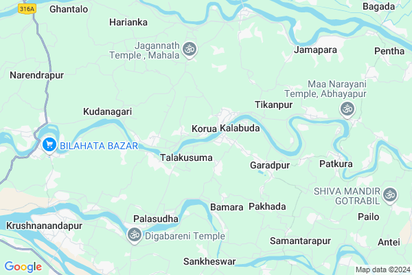
Nedala
Nedala Map
EDIT Map
Add Your House
 ..
..
Current Corona Virus Infected Patients Count in Kendrapara District
| City Name | District Name | Total Covid cases |
|---|---|---|
| Kendrapara District | Kendrapara | 2 |
Locality Name :
Nedala
( ନେଦଲେ )
Tehsil Name : Garadapur
District : Kendrapara
State : Odisha
Language : Oriya and Hindi
Current Time 05:51 PM
Date: Thursday , Apr 24,2025 (IST)
Time zone: IST (UTC+5:30)
Elevation / Altitude: 9 meters. Above Seal level
Telephone Code / Std Code: 06725
Assembly constituency : Patkura assembly constituency
Assembly MLA : bed prakash agarwalla
Lok Sabha constituency : Kendrapara parliamentary constituency
Parliament MP : Anubhav Mohanty
Serpanch Name :
Alternate Village Name : Nedalo
Commodities Prices : Gopa Market / Mandi
Nedala Live Weather
Temperature: 32.5 °C
clear sky
Humidity: 55%
Wind : 7.47 mt/sec towards S
StationName : "KendrÄ\u0081parha"
observed on 10 Mins Back
Temperature: 32.5 °C
clear sky
Humidity: 55%
Wind : 7.47 mt/sec towards S
StationName : "KendrÄ\u0081parha"
observed on 10 Mins Back
Nedala Weather Forecast for Next 5 days
25-04-2025
28.2°C to 31.2°C
clear sky
28.2°C to 31.2°C
clear sky
26-04-2025
27.5°C to 40.4°C
clear sky
27.5°C to 40.4°C
clear sky
27-04-2025
27.4°C to 37.3°C
few clouds, clear sky, scattered clouds
27.4°C to 37.3°C
few clouds, clear sky, scattered clouds
28-04-2025
27.8°C to 39.2°C
scattered clouds, few clouds, light rain
27.8°C to 39.2°C
scattered clouds, few clouds, light rain
29-04-2025
26.6°C to 38.0°C
broken clouds, overcast clouds, light rain
26.6°C to 38.0°C
broken clouds, overcast clouds, light rain
National Highways Reachable To Nedala
Nationa High Way :NH316
Nationa High Way :NH53
Nationa High Way :NH316
Nationa High Way :NH53
Rivers Near Nedala
Brahmani :Брагмані
Ramlala
Brahmani :Брагмані
Ramlala
About Nedala
Correct below Info and add more info about NedalaNedala is a small Village/hamlet in Garadapur Tehsil in Kendrapara District of Odisha State, India. It is located 17 KM towards South from District head quarters Kendrapara. 63 KM from State capital Bhubaneswar
Nedala is surrounded by Marsaghai Tehsil towards East , Tirtol Tehsil towards South , Derabish Tehsil towards North , Raghunathpur Tehsil towards west .
Kendrapara , Jagatsinghapur , Paradip , Pattamundai are the near by Cities to Nedala.
This Place is in the border of the Kendrapara District and Jagatsinghapur District. Jagatsinghapur District Tirtol is South towards this place .
Nedalo 2011 Census Details
Nedala Local Language is Oriya. Nedalo Village Total population is 156 and number of houses are 47. Female Population is 48.7%. Village literacy rate is 78.8% and the Female Literacy rate is 37.2%.
Population
| Census Parameter | Census Data |
| Total Population | 156 |
| Total No of Houses | 47 |
| Female Population % | 48.7 % ( 76) |
| Total Literacy rate % | 78.8 % ( 123) |
| Female Literacy rate | 37.2 % ( 58) |
| Scheduled Tribes Population % | 0.0 % ( 0) |
| Scheduled Caste Population % | 2.6 % ( 4) |
| Working Population % | 29.5 % |
| Child(0 -6) Population by 2011 | 13 |
| Girl Child(0 -6) Population % by 2011 | 30.8 % ( 4) |
Nedalo Census More Deatils.
Politics in Nedala
AITC , BJD are the major political parties in this area.Polling Stations /Booths near Nedala
1)Kodapala Pry School2)Korua Kanchilo Pry School
3)Talagan Primary School
4)Girigola Pry.school
5)Goudagan Primary School
HOW TO REACH Nedala
By Rail
There is no railway station near to Nedala in less than 10 km.Pincodes near Nedala
754153 ( Garadpur ) , 754026 ( Daulatabad (Cuttack) ) , 754228 ( Patakura (Kendrapara) )Colleges near Nedala
Laxmi Barah College, Ayatpur, Aul, Kendrapara
Address :
B.r. Science College
Address :
Birupa College, Indupur
Address :
Dayanidhi Sanskrit Degree College Potari
Address : At Potari ,po Batira Pin_ 754140
Sri Sri Jagannath Mohavidyalaya
Address :
Schools in Nedala
Bhadalo P. S.
Address : nedalo , garadapur , kendrapara , Sikkim . PIN- 754134 , Post - Tyandakura
Govt Health Centers near Nedala
1) Gardapur PHC(N) , , Patkura , Near Patkura Block Office2) ORTI , , , Orti PHC (New)
3) NAGASPUR , , , Nagaspur Chhak
Governement Offices near Nedala,Garadapur
CSC Kalabuda; Jana Seva Kendra
Laxmi Market Complex; Kalabuda; Odisha 754153; India
1.8 KM distance Detail
About Nedala &
History
How to reach Nedala
Tourist Places Near By Nedala
Schools in Nedala
Colleges in Nedala
Temperature & weather of Nedala
places in Nedala
Nedala photos
More Information
How to reach Nedala
Tourist Places Near By Nedala
Schools in Nedala
Colleges in Nedala
Temperature & weather of Nedala
places in Nedala
Nedala photos
More Information
Village Talk
Post News or Events about this Village
Near Cities
Kendrapara 15 KM near
Jagatsinghapur 25 KM near
Paradip 34 KM near
Pattamundai 34 KM near
Kendrapara 15 KM near
Jagatsinghapur 25 KM near
Paradip 34 KM near
Pattamundai 34 KM near
Near By Taluks
Garadapur 0 KM near
Marsaghai 14 KM near
Tirtol 15 KM near
Derabish 15 KM near
Garadapur 0 KM near
Marsaghai 14 KM near
Tirtol 15 KM near
Derabish 15 KM near
Near By Air Ports
Bhubaneswar Airport 63 KM near
Netaji Subhas Chandra Bose Airport 370 KM near
Ranchi Airport 381 KM near
Vishakhapatnam Airport 494 KM near
Bhubaneswar Airport 63 KM near
Netaji Subhas Chandra Bose Airport 370 KM near
Ranchi Airport 381 KM near
Vishakhapatnam Airport 494 KM near
Near By Tourist Places
Paradeep Beach 34 KM near
Cuttack 54 KM near
Nandan Kanan National Park 61 KM near
Bhubaneswar 61 KM near
Konark 69 KM near
Paradeep Beach 34 KM near
Cuttack 54 KM near
Nandan Kanan National Park 61 KM near
Bhubaneswar 61 KM near
Konark 69 KM near
Near By Districts
Kendrapara 16 KM near
Jagatsinghapur 26 KM near
Cuttack 53 KM near
Jajapur 56 KM near
Kendrapara 16 KM near
Jagatsinghapur 26 KM near
Cuttack 53 KM near
Jajapur 56 KM near
Near By RailWay Station
Cuttack Junction Rail Way Station 51 KM near
Mancheswar Rail Way Station 58 KM near
Cuttack Junction Rail Way Station 51 KM near
Mancheswar Rail Way Station 58 KM near