| Home | City Bus | Maps | Villages | Cities | Rail | Tourist Places | School | College | Pin Codes | Corona Cases Count |
| Distance Calculator Bus Services IFSC Codes Trace Mobile Number Weather Search Place Trace IP Available Cash ATM/Banks Locate Polling Booth Report an Error contact People |
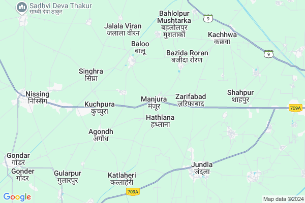
Manjoora
Manjoora Map
EDIT Map
Add Your House
 ..
..
Current Corona Virus Infected Patients Count in Karnal District
| City Name | District Name | Total Covid cases |
|---|---|---|
| Karnal District | Karnal | 6 |
Locality Name :
Manjoora
( मंजूर )
Tehsil Name : Nissing At Chirao
District : Karnal
State : Haryana
Division : Rohtak
Language : Hindi and Punjabi, Haryanvi
Current Time 11:11 AM
Date: Sunday , Apr 27,2025 (IST)
Time zone: IST (UTC+5:30)
Elevation / Altitude: 253 meters. Above Seal level
Telephone Code / Std Code: 0184
Assembly constituency : Assandh assembly constituency
Assembly MLA : Shamsher Singh Gogi
Lok Sabha constituency : Karnal parliamentary constituency
Parliament MP : Sanjay Bhatia
Serpanch Name :
Pin Code : 132001
Post Office Name : Karnal
Commodities Prices : Gharaunda Market / Mandi
Manjoora Live Weather
Temperature: 41.3 °C
clear sky
Humidity: 5%
Wind : 1.21 mt/sec towards W
StationName : "KarnÄ\u0081l"
observed on Now
Temperature: 41.3 °C
clear sky
Humidity: 5%
Wind : 1.21 mt/sec towards W
StationName : "KarnÄ\u0081l"
observed on Now
Manjoora Weather Forecast for Next 5 days
28-04-2025
28.1°C to 41.7°C
clear sky
28.1°C to 41.7°C
clear sky
29-04-2025
25.3°C to 43.3°C
clear sky
25.3°C to 43.3°C
clear sky
30-04-2025
26.5°C to 43.5°C
clear sky, few clouds
26.5°C to 43.5°C
clear sky, few clouds
01-05-2025
27.4°C to 42.9°C
scattered clouds, overcast clouds, broken clouds, clear sky
27.4°C to 42.9°C
scattered clouds, overcast clouds, broken clouds, clear sky
02-05-2025
28.2°C to 41.8°C
few clouds, clear sky, broken clouds, overcast clouds
28.2°C to 41.8°C
few clouds, clear sky, broken clouds, overcast clouds
National Highways Reachable To Manjoora
Nationa High Way :NH44
Nationa High Way :NH152;352
Nationa High Way :NH44
Nationa High Way :NH152;352
About Manjoora
Correct below Info and add more info about ManjooraManjoora is a Village in Nissing At Chirao Tehsil in Karnal District of Haryana State, India. It belongs to Rohtak Division . It is located 16 KM towards west from District head quarters Karnal. 1 KM from Nissang. 135 KM from State capital Chandigarh
Manjoora Pin code is 132001 and postal head office is Karnal .
Buddanpur Viran ( 2 KM ) , Zarifabad ( 2 KM ) , Balu ( 3 KM ) , Bazida Roran ( 3 KM ) , Kuchpura ( 4 KM ) are the nearby Villages to Manjoora. Manjoora is surrounded by Karnal Tehsil towards East , Nilokheri Tehsil towards North , Gharaunda (Part) Tehsil towards South , Pundri Tehsil towards west .
Karnal , Taraori , Gharaunda , Assandh are the near by Cities to Manjoora.
Manjoora 2011 Census Details
Manjoora Local Language is Hindi. Manjoora Village Total population is 2556 and number of houses are 480. Female Population is 47.0%. Village literacy rate is 65.0% and the Female Literacy rate is 26.7%.
Population
| Census Parameter | Census Data |
| Total Population | 2556 |
| Total No of Houses | 480 |
| Female Population % | 47.0 % ( 1202) |
| Total Literacy rate % | 65.0 % ( 1662) |
| Female Literacy rate | 26.7 % ( 683) |
| Scheduled Tribes Population % | 0.0 % ( 0) |
| Scheduled Caste Population % | 31.6 % ( 807) |
| Working Population % | 39.9 % |
| Child(0 -6) Population by 2011 | 321 |
| Girl Child(0 -6) Population % by 2011 | 47.4 % ( 152) |
Manjoora Census More Deatils.
Politics in Manjoora
HJCBL , BJP , BSP , INC , INLD are the major political parties in this area.HOW TO REACH Manjoora
By Rail
There is no railway station near to Manjoora in less than 10 km.Colleges near Manjoora
Diet Shahpur
Address :
Schools near Manjoora
Maharishi Ved Vyas Sss Bastli
Address : bastli , nissing , karnal , Haryana . PIN- 132024 , Post - Nissing
Arya Shiksha Niketan Budanpur Abad
Address : budanpur abad , nissing , karnal , Haryana . PIN- 132114 , Post - Gharunda
Mnm Public School Jundla
Address : jundla , nissing , karnal , Haryana . PIN- 132036 , Post - Jundla
Geeta Sr. Sec. School Peont
Address : peont , nissing , karnal , Haryana . PIN- 132032
Govt Health Centers near Manjoora
1) SAGGA , , ,2) PHC Sagga , , ,
3) KALHERI , , ,
Petrol Bunks in Manjoora,Nissing At Chirao
Mahavir Petro Company Indian Oil Petrol Pump
Karnal - Kaithal Rd; Karnal; Haryana 132024; India
1.1 KM distance Detail
Hindustan Petroleum
Nisang; Karnal; SH-8; Kaithal Road; Karnal; Karnal; Haryana 132024; India
5.3 KM distance Detail
more ..
Colleges in Manjoora,Nissing At Chirao
Pratap College of Education; Jundla
Near Bus Stand; Assandh Road; Opp Canara Bank; Jundla; Karnal; Haryana 132036; India
5.7 KM distance Detail
more ..
Schools in Manjoora,Nissing At Chirao
Government Senior Secondary School
Karnal - Kaithal Rd; Karnal; Haryana 132024; India
0.0 KM distance Detail
Electronic Shops in Manjoora,Nissing At Chirao
virk shop
V P O; Near Devi Mandir; State Highway 12; Jundla; Haryana 132036; India
5.9 KM distance Detail
Police Stations near Manjoora,Nissing At Chirao
New Police Line Karnal
Khatha Road; Mustfabad; Karnal; Haryana 132036; India
11.5 KM distance Detail
Governement Offices near Manjoora,Nissing At Chirao
Agriculture Development Office
Karnal - Kaithal Rd; Karnal; Haryana 132024; India
0.2 KM distance Detail
CSVP Office Vikas Colony Karnal
New Anaj Mandi Road;; Anand Vihar Colony; Karnal; Haryana 132001; India
15.1 KM distance Detail
Vinay Stationery House
Hansi Road; Near Prachin Mata Vaishnu Devi Mandir; Karnal; Haryana 132001; India
15.2 KM distance Detail
About Manjoora &
History
How to reach Manjoora
Tourist Places Near By Manjoora
Schools in Manjoora
Colleges in Manjoora
Temperature & weather of Manjoora
places in Manjoora
Manjoora photos
More Information
How to reach Manjoora
Tourist Places Near By Manjoora
Schools in Manjoora
Colleges in Manjoora
Temperature & weather of Manjoora
places in Manjoora
Manjoora photos
More Information
Village Talk
Post News or Events about this Village
Near Cities
Karnal 16 KM near
Taraori 17 KM near
Gharaunda 22 KM near
Assandh 33 KM near
Karnal 16 KM near
Taraori 17 KM near
Gharaunda 22 KM near
Assandh 33 KM near
Near By Taluks
Nissing At Chirao 0 KM near
Karnal 18 KM near
Nilokheri 20 KM near
Gharaunda (Part) 24 KM near
Nissing At Chirao 0 KM near
Karnal 18 KM near
Nilokheri 20 KM near
Gharaunda (Part) 24 KM near
Near By Air Ports
Muzaffarnagar Airport 95 KM near
Chandigarh Airport 122 KM near
Indira Gandhi International Airport 143 KM near
Dehra Dun Airport 150 KM near
Muzaffarnagar Airport 95 KM near
Chandigarh Airport 122 KM near
Indira Gandhi International Airport 143 KM near
Dehra Dun Airport 150 KM near
Near By Tourist Places
Karna lake 16 KM near
Kurukshetra 38 KM near
panipat 40 KM near
Yamuna-Nagar 69 KM near
Patel Park in Ambala Cantt 86 KM near
Karna lake 16 KM near
Kurukshetra 38 KM near
panipat 40 KM near
Yamuna-Nagar 69 KM near
Patel Park in Ambala Cantt 86 KM near
Near By Districts
Karnal 15 KM near
Kurukshetra 34 KM near
Panipat 40 KM near
Kaithal 47 KM near
Karnal 15 KM near
Kurukshetra 34 KM near
Panipat 40 KM near
Kaithal 47 KM near
Near By RailWay Station
Karnal Rail Way Station 14 KM near
Gharaunda Rail Way Station 22 KM near
Karnal Rail Way Station 14 KM near
Gharaunda Rail Way Station 22 KM near