| Home | City Bus | Maps | Villages | Cities | Rail | Tourist Places | School | College | Pin Codes | Corona Cases Count |
| Distance Calculator Bus Services IFSC Codes Trace Mobile Number Weather Search Place Trace IP Available Cash ATM/Banks Locate Polling Booth Report an Error contact People |
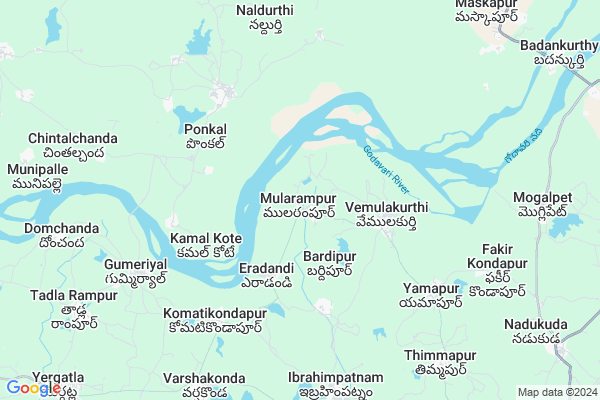
Mularampur
Mularampur Map
EDIT Map
Add Your House
 ..
..
Current Corona Virus Infected Patients Count in Karimnagar District
| City Name | District Name | Total Covid cases |
|---|---|---|
| Karimnagar District | Karimnagar | 16 |
| Karimnagar | Karimnagar | 3 |
| Rajanna Sircilla District | Rajanna Sircilla | 3 |
| Peddapalli District | Peddapalli | 2 |
| Siddipet District | Siddipet | 1 |
Locality Name :
Mularampur
( మూలరాంపూర్ )
Mandal Name : Ibrahimpatnam
District : Karimnagar
State : Telangana
Region : Telangana
Language : Telugu and Urdu
Current Time 12:45 PM
Date: Thursday , Apr 24,2025 (IST)
Time zone: IST (UTC+5:30)
Elevation / Altitude: 293 meters. Above Seal level
Telephone Code / Std Code: 08725
Assembly constituency : Koratla assembly constituency
Assembly MLA : Kalvakuntla Sanjay
Lok Sabha constituency : Nizamabad parliamentary constituency
Parliament MP : ARVIND DHARMAPURI
Serpanch Name :
Pin Code : 505450
Post Office Name : Ibrahimpatnam (Karim Nagar)
Commodities Prices : Ibrahimpatnam Market / Mandi
Mularampur Live Weather
Temperature: 42.9 °C
clear sky
Humidity: 9%
Wind : 3.21 mt/sec towards NE
StationName : "Koratla"
observed on Now
Temperature: 42.9 °C
clear sky
Humidity: 9%
Wind : 3.21 mt/sec towards NE
StationName : "Koratla"
observed on Now
Mularampur Weather Forecast for Next 5 days
25-04-2025
32.6°C to 44.0°C
clear sky, scattered clouds, few clouds
32.6°C to 44.0°C
clear sky, scattered clouds, few clouds
26-04-2025
31.3°C to 43.8°C
scattered clouds, few clouds, clear sky, broken clouds
31.3°C to 43.8°C
scattered clouds, few clouds, clear sky, broken clouds
27-04-2025
30.3°C to 41.4°C
broken clouds, overcast clouds, clear sky, light rain
30.3°C to 41.4°C
broken clouds, overcast clouds, clear sky, light rain
28-04-2025
27.9°C to 38.6°C
broken clouds, overcast clouds, light rain, scattered clouds, clear sky
27.9°C to 38.6°C
broken clouds, overcast clouds, light rain, scattered clouds, clear sky
29-04-2025
26.9°C to 42.6°C
clear sky, few clouds
26.9°C to 42.6°C
clear sky, few clouds
Rivers Near Mularampur
Peddayya VAgu
Godavari :ગોદાવરી :गोदावरी :ಗೋದಾವರೀ :गोदावरी :గోదావరి
Peddayya VAgu
Godavari :ગોદાવરી :गोदावरी :ಗೋದಾವರೀ :गोदावरी :గోదావరి
About Mularampur
Correct below Info and add more info about MularampurMularampur is a Village in Ibrahimpatnam Mandal in Karimnagar District of Telangana State, India. It belongs to Telangana region . It is located 98 KM towards North from District head quarters Karimnagar. 5 KM from Ibrahimpatnam.
Mularampur Pin code is 505450 and postal head office is Ibrahimpatnam (Karim Nagar).
Eradandi ( 3 KM ) , Vemulakurthy ( 3 KM ) , Komatikondapur ( 5 KM ) , Yamapur ( 6 KM ) , Ibrahimpatnam ( 8 KM ) are the nearby Villages to Mularampur. Mularampur is surrounded by Mamda Mandal towards North , Mallapur Mandal towards East , Laxmanchanda Mandal towards west , Khanapur Mandal towards North .
Koratla , Nirmal , Jagtial , Nizamabad are the near by Cities to Mularampur.
This Place is in the border of the Karimnagar District and Nizamabad District. Nizamabad District Kammarapalle is South towards this place . Also it is in the Border of other district Adilabad .
Demographics of Mularampur
Telugu is the Local Language here. Total population of Mularampur is 711 .Males are 348 and Females are 363 living in 168 Houses. Total area of Mularampur is 600 hectares.Politics in Mularampur
TRS , INC are the major political parties in this area.Polling Stations /Booths near Mularampur
1)Mohanraopeta2)Bandalingapur
3)Dharmaram
4)Erdandi
5)Vempalli Venkatraopeta
HOW TO REACH Mularampur
By Road
Koratla is the Nearest Town to Mularampur. Koratla is 28 km from Mularampur. Road connectivity is there from Koratla to Mularampur.By Rail
There is no railway station near to Mularampur in less than 10 km.Colleges near Mularampur
Govt Colleage
Address : Near Zphs School
Schools in Mularampur
Mpps Mularampur
Address : mularampur , ibrahimpatnam , karimnagar , Andhra Pradesh . PIN- 505450 , Post - Ibrahimpatnam (Karim Nagar)
Govt Health Centers near Mularampur
1) Subcentre Erdandi , 5-112, , Bus Stand Area , Bus Stand Area2) Subcentre Vemulakurthy , 2-51, , Grama Pnachayithi , Banjarudoddi
3) SubCentre, Kamalkota , 26-Feb , BC Colony, , G.P.
Hospitals in Mularampur,Ibrahimpatnam
శ్రీ సాయి క్లినిక్ ( ప్రథమ చికిత్స కేంద్రం )
Gummiryal; Telangana 503308; India
7.3 KM distance Detail
more ..
Petrol Bunks in Mularampur,Ibrahimpatnam
HP PETROL PUMP - SRI MALLIKARJUNA FS
Survey NO 439 Ibrahim Patnam TS; Ibrahimpatnam; Telangana 505450; India
9.8 KM distance Detail
Ganesh Filling Station
Badankurty; khanapur; Nirmal; Telangana 504203; India
12.2 KM distance Detail
more ..
Colleges in Mularampur,Ibrahimpatnam
Government Junior College
Gonekapu Wada; Ibrahimpatnam; Telangana 505450; India
8.5 KM distance Detail
Govt Junior College.Ibrahimpatnam 505450
Ibrahimpatnam; Telangana 505450; India
9.3 KM distance Detail
more ..
Super Markets in Mularampur,Ibrahimpatnam
Prasad Goud General Store
New Bus Stand Main Road; Ibrahimpatnam; Telangana 505450; India
8.7 KM distance Detail
Governement Offices near Mularampur,Ibrahimpatnam
MeeSeva Center
Thadpakal X Road; ;Morthad; Thalla Rampur; Telangana 503308; India
10.5 KM distance Detail
MeeSeva Center
Near Bus station ;Morthad ;; Yergatla; Telangana 503308; India
13.0 KM distance Detail
About Mularampur &
History
How to reach Mularampur
Tourist Places Near By Mularampur
Schools in Mularampur
Colleges in Mularampur
Temperature & weather of Mularampur
places in Mularampur
Mularampur photos
More Information
How to reach Mularampur
Tourist Places Near By Mularampur
Schools in Mularampur
Colleges in Mularampur
Temperature & weather of Mularampur
places in Mularampur
Mularampur photos
More Information
Village Talk
Post News or Events about this Village
Near Cities
Koratla 25 KM near
Nirmal 31 KM near
Jagtial 46 KM near
Nizamabad 69 KM near
Koratla 25 KM near
Nirmal 31 KM near
Jagtial 46 KM near
Nizamabad 69 KM near
Near By Taluks
Ibrahimpatnam 4 KM near
Mamda 12 KM near
Mallapur 14 KM near
Laxmanchanda 16 KM near
Ibrahimpatnam 4 KM near
Mamda 12 KM near
Mallapur 14 KM near
Laxmanchanda 16 KM near
Near By Air Ports
Nanded Airport 149 KM near
Rajiv Gandhi International Airport 216 KM near
Latur Airport 257 KM near
Sonegaon Airport 270 KM near
Nanded Airport 149 KM near
Rajiv Gandhi International Airport 216 KM near
Latur Airport 257 KM near
Sonegaon Airport 270 KM near
Near By Tourist Places
Medak 120 KM near
Sirpur 134 KM near
Chandrapur 149 KM near
Warangal 172 KM near
Bidar 179 KM near
Medak 120 KM near
Sirpur 134 KM near
Chandrapur 149 KM near
Warangal 172 KM near
Bidar 179 KM near
Near By Districts
Nizamabad 67 KM near
Adilabad 88 KM near
Karimnagar 94 KM near
Nanded 150 KM near
Nizamabad 67 KM near
Adilabad 88 KM near
Karimnagar 94 KM near
Nanded 150 KM near
Near By RailWay Station
Nizamabad Junction Rail Way Station 65 KM near
Basar Rail Way Station 75 KM near
Nizamabad Junction Rail Way Station 65 KM near
Basar Rail Way Station 75 KM near