| Home | City Bus | Maps | Villages | Cities | Rail | Tourist Places | School | College | Pin Codes | Corona Cases Count |
| Distance Calculator Bus Services IFSC Codes Trace Mobile Number Weather Search Place Trace IP Available Cash ATM/Banks Locate Polling Booth Report an Error contact People |
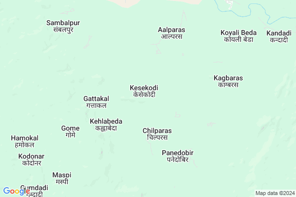
Kesekodi
Kesekodi Map
EDIT Map
Add Your House
 ..
..
Current Corona Virus Infected Patients Count in Kanker District
| City Name | District Name | Total Covid cases |
|---|
Locality Name :
Kesekodi
( केसकोडी )
Tehsil Name : Koilebeda
District : Kanker
State : Chattisgarh
Language : Chhattisgarhi and Hindi, Gondi And Halbi
Current Time 12:31 PM
Date: Wednesday , Apr 30,2025 (IST)
Time zone: IST (UTC+5:30)
Telephone Code / Std Code: 07840
Assembly constituency : Antagarh assembly constituency
Assembly MLA : Vikram Usendi
Lok Sabha constituency : Kanker parliamentary constituency
Parliament MP : MOHAN MANDAVI
Serpanch Name :
Pin Code : 494661
Post Office Name : Narayanpur (Narayanpur)
Commodities Prices : Narayanpur Market / Mandi
Rivers Near Kesekodi
Kotri
Bandia
Kotri
Bandia
About Kesekodi
Correct below Info and add more info about KesekodiKesekodi is a Village in Koilebeda Tehsil in Kanker District of Chattisgarh State, India. It is located 81 KM towards west from District head quarters Kanker. 15 KM from Koilibeda. 194 KM from State capital Raipur
Kesekodi Pin code is 494661 and postal head office is Narayanpur (Narayanpur).
Aalparas ( 5 KM ) , Udanpur ( 10 KM ) , Sulangi ( 15 KM ) , Kamteda ( 16 KM ) are the nearby Villages to Kesekodi. Kesekodi is surrounded by Antagarh Tehsil towards East , Durgukondal Tehsil towards North , Bhanupratappur Tehsil towards North , Narayanpur Tehsil towards East .
Kanker , Dalli-Rajhara , Kondagaon , Balod are the near by Cities to Kesekodi.
Kesekodi 2011 Census Details
Kesekodi Local Language is Chhattisgarhi. Kesekodi Village Total population is 668 and number of houses are 165. Female Population is 49.3%. Village literacy rate is 17.5% and the Female Literacy rate is 6.9%.
Population
| Census Parameter | Census Data |
| Total Population | 668 |
| Total No of Houses | 165 |
| Female Population % | 49.3 % ( 329) |
| Total Literacy rate % | 17.5 % ( 117) |
| Female Literacy rate | 6.9 % ( 46) |
| Scheduled Tribes Population % | 88.2 % ( 589) |
| Scheduled Caste Population % | 0.0 % ( 0) |
| Working Population % | 58.7 % |
| Child(0 -6) Population by 2011 | 66 |
| Girl Child(0 -6) Population % by 2011 | 51.5 % ( 34) |
Kesekodi Census More Deatils.
Politics in Kesekodi
Bharatiya Janata Party , BJP , API , INC are the major political parties in this area.Polling Stations /Booths near Kesekodi
1)Karregaon2)Furfundi
3)Panavar ~kh
4)Panidobir~1
5)Govindpur
HOW TO REACH Kesekodi
By Rail
There is no railway station near to Kesekodi in less than 10 km.Colleges near Kesekodi
Government Veer Gend Singh Collage,pakhanjore
Address : P.v.116,sangam Road,pakhanjore
Schools near Kesekodi
Govt. Middle School Sohagaon
Address : sohagaon , koyalibeda , kanker , Chattisgarh . PIN- 494776 , Post - Pakhanjore Camp
Govt. Middle School P.v. 74
Address : p.v.74 , koyalibeda , kanker , Chattisgarh . PIN- 494777 , Post - Bandecolony
Govt. Middle School P.v. 09+10+11
Address : p.v.9+10+11 krishan , koyalibeda , kanker , Chattisgarh . PIN- 494776 , Post - Pakhanjore Camp
Govt. Middle School Nahagida
Address : nahagida , koyalibeda , kanker , Chattisgarh . PIN- 494771 , Post - Chotekapsi
Govt Health Centers near Kesekodi
1) SHC Gome , Sub Health Centre , Main Road,Gome , SHC Gome2) CHC Koilibeda , , ,
3) SHC Koilibeda , , ,
Schools in Kesekodi,Koilebeda
Electronic Shops in Kesekodi,Koilebeda
Super Markets in Kesekodi,Koilebeda
Local Parks in Kesekodi,Koilebeda
Police Stations near Kesekodi,Koilebeda
Governement Offices near Kesekodi,Koilebeda
About Kesekodi &
History
How to reach Kesekodi
Tourist Places Near By Kesekodi
Schools in Kesekodi
Colleges in Kesekodi
Temperature & weather of Kesekodi
places in Kesekodi
Kesekodi photos
More Information
How to reach Kesekodi
Tourist Places Near By Kesekodi
Schools in Kesekodi
Colleges in Kesekodi
Temperature & weather of Kesekodi
places in Kesekodi
Kesekodi photos
More Information
Village Talk
Post News or Events about this Village
Near Cities
Kanker 77 KM near
Dalli-Rajhara 87 KM near
Kondagaon 92 KM near
Balod 109 KM near
Kanker 77 KM near
Dalli-Rajhara 87 KM near
Kondagaon 92 KM near
Balod 109 KM near
Near By Taluks
Koilebeda 15 KM near
Antagarh 34 KM near
Durgukondal 43 KM near
Bhanupratappur 53 KM near
Koilebeda 15 KM near
Antagarh 34 KM near
Durgukondal 43 KM near
Bhanupratappur 53 KM near
Near By Air Ports
Raipur Airport 185 KM near
Sonegaon Airport 267 KM near
Rajahmundry Airport 360 KM near
Jabalpur Airport 366 KM near
Raipur Airport 185 KM near
Sonegaon Airport 267 KM near
Rajahmundry Airport 360 KM near
Jabalpur Airport 366 KM near
Near By Tourist Places
Bhamragarh Wildlife Sanctuary 73 KM near
Kanker 78 KM near
Dhamtari 123 KM near
Dantewada 132 KM near
Rajnandgaon 150 KM near
Bhamragarh Wildlife Sanctuary 73 KM near
Kanker 78 KM near
Dhamtari 123 KM near
Dantewada 132 KM near
Rajnandgaon 150 KM near
Near By Districts
Narayanpur 41 KM near
Kanker 77 KM near
Gadchiroli 118 KM near
Dhamtari 121 KM near
Narayanpur 41 KM near
Kanker 77 KM near
Gadchiroli 118 KM near
Dhamtari 121 KM near
Near By RailWay Station
Raj Nandgaon Rail Way Station 151 KM near
Dongargarh Rail Way Station 163 KM near
Raj Nandgaon Rail Way Station 151 KM near
Dongargarh Rail Way Station 163 KM near