| Home | City Bus | Maps | Villages | Cities | Rail | Tourist Places | School | College | Pin Codes | Corona Cases Count |
| Distance Calculator Bus Services IFSC Codes Trace Mobile Number Weather Search Place Trace IP Available Cash ATM/Banks Locate Polling Booth Report an Error contact People |
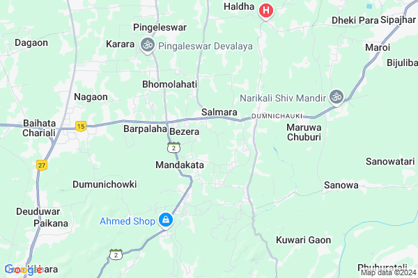
Saraighat Map
EDIT Map
Add Your House
 ..
..
Current Corona Virus Infected Patients Count in Kamrup District
| City Name | District Name | Total Covid cases |
|---|---|---|
| Kamrup District | Kamrup | 1 |
Locality Name :
Saraighat
( सरायघाट )
Tehsil Name : Bezera
District : Kamrup
State : Assam
Language : Assamese and Bodo, Karbi, Rabha, Boro, Garo, Tiwa
Current Time 12:50 PM
Date: Sunday , Apr 27,2025 (IST)
Time zone: IST (UTC+5:30)
Elevation / Altitude: 55 meters. Above Seal level
Telephone Code / Std Code: 0361
Assembly constituency : Jalukbari assembly constituency
Assembly MLA : Himanta Biswa Sarma
Lok Sabha constituency : Gauhati parliamentary constituency
Parliament MP : QUEEN OJA
Serpanch Name :
Pin Code : 781121
Post Office Name : Bezera
Commodities Prices : Mawiong Regulated Market Market / Mandi
Rivers Near Saraighat
Kopili
Khulsi River
Kopili
Khulsi River
About Saraighat
Correct below Info and add more info about SaraighatSaraighat is a Village in Bezera Tehsil in Kamrup District of Assam State, India. It is located 35 KM towards East from District head quarters Goroimari. 2 KM from Bezera. 26 KM from State capital Dispur
Saraighat Pin code is 781121 and postal head office is Bezera .
Titkuchi ( 3 KM ) , Agdola ( 6 KM ) , Gopeswar ( 6 KM ) , Nagaon ( 7 KM ) , Karara ( 7 KM ) are the nearby Villages to Saraighat. Saraighat is surrounded by Bezera (Pt) Tehsil towards west , Sipajhar Tehsil towards East , Bihdia Tehsil towards North , Kamalpur(Pt.) Tehsil towards west .
Guwahati , Dispur , Rangia , Mangaldoi are the near by Cities to Saraighat.
This Place is in the border of the Kamrup District and Darrang District. Darrang District Sipajhar is East towards this place . Also it is in the Border of other district Kamrup Metro .
Saraighat Salmara 2011 Census Details
Saraighat Local Language is Assamese. Saraighat Salmara Village Total population is 1886 and number of houses are 408. Female Population is 49.2%. Village literacy rate is 79.8% and the Female Literacy rate is 38.0%.
Population
| Census Parameter | Census Data |
| Total Population | 1886 |
| Total No of Houses | 408 |
| Female Population % | 49.2 % ( 928) |
| Total Literacy rate % | 79.8 % ( 1505) |
| Female Literacy rate | 38.0 % ( 716) |
| Scheduled Tribes Population % | 0.0 % ( 0) |
| Scheduled Caste Population % | 0.3 % ( 5) |
| Working Population % | 33.5 % |
| Child(0 -6) Population by 2011 | 158 |
| Girl Child(0 -6) Population % by 2011 | 42.4 % ( 67) |
Saraighat Salmara Census More Deatils.
Politics in Saraighat
85.18% , Bharatiya Janata Party , 75974 , BJP , INC are the major political parties in this area.Polling Stations /Booths near Saraighat
1)Rudreswar L.p School (r/w)2)Salmara L.p School (l/w)
3)Sila Karoibari L.p School (r/w)
4)Alikash Bamunbari High Madrasa (r/w)
5)Alta L.p School (l/w)
HOW TO REACH Saraighat
By Rail
There is no railway station near to Saraighat in less than 10 km.Colleges near Saraighat
Chhaygaon College
Address :
Fakuruddin Ali Ahmed College
Address :
Bpc College
Address :
Chhamaria Anchalik College
Address : Venue- Chamaria (kahibari)
Asom Sikshak Prasikshan Mahavidyalaya
Address : P.o.-lankeswar,dist.-kamrup,assam– 781014
Schools in Saraighat
Kampith Vidya Mandir
Address : saraighat , karara , kamrup , Assam . PIN- 781121 , Post - Bezera
Saraighat Mes
Address : saraighat , karara , kamrup , Assam . PIN- 781121 , Post - Bezera
Govt Health Centers near Saraighat
1) GANESH KUNWARI SC , GANESH KUNWARI SC , BAZANAPATHAR-KURUA SECTOR , NEAR GANESH MANDIR2) KHALIHOI SC (B) , KHALIHOI SC (B) , BAZANAPATHAR-KURUA SECTOR ,
3) DHEKIPARA SC , DHEKIPARA SC , Lawjan-Dumunichowki SD ,
Petrol Bunks in Saraighat,Bezera
Ms Danmel Sogani and Sons Assam Oil
Baihata Chariali; Kamrup; NH-31; Guwahati Road; Baihata; Baihata; Assam 781381; India
8.6 KM distance Detail
Kamalpur service station
381; Guwahati - Baihata Rd; Baihata; Assam 781380; India
9.6 KM distance Detail
more ..
Colleges in Saraighat,Bezera
EXPOSURE EDUCATION
MONGOLDOI ROAD; BAIHATA CHARIALI; GUWAHATI; Assam 781381; India
8.5 KM distance Detail
more ..
Schools in Saraighat,Bezera
Mandakata Simeli Bari Anchalik M E Madrasa And High School
; Simelibari; Assam 781121; India
1.3 KM distance Detail
Local Parks in Saraighat,Bezera
Sector 1 Township Park
Ramchai Hills; Ganesh Nagar; Noonmati; Guwahati; Assam 781004; India
17.8 KM distance Detail
Governement Offices near Saraighat,Bezera
Nagaon Water Supply Board
Baihata Chariali; Kamrup; NH-31; Barpeta Road; Baihata; Baihata; Assam 781381; India
9.1 KM distance Detail
About Saraighat &
History
How to reach Saraighat
Tourist Places Near By Saraighat
Schools in Saraighat
Colleges in Saraighat
Temperature & weather of Saraighat
places in Saraighat
Saraighat photos
More Information
How to reach Saraighat
Tourist Places Near By Saraighat
Schools in Saraighat
Colleges in Saraighat
Temperature & weather of Saraighat
places in Saraighat
Saraighat photos
More Information
Village Talk
Post News or Events about this Village
Near Cities
Guwahati 20 KM near
Dispur 23 KM near
Rangia 24 KM near
Mangaldoi 27 KM near
Guwahati 20 KM near
Dispur 23 KM near
Rangia 24 KM near
Mangaldoi 27 KM near
Near By Taluks
Bezera 2 KM near
Bezera (Pt) 2 KM near
Sipajhar 13 KM near
Bihdia 13 KM near
Bezera 2 KM near
Bezera (Pt) 2 KM near
Sipajhar 13 KM near
Bihdia 13 KM near
Near By Air Ports
Borjhar Airport 37 KM near
Shillong Airport 96 KM near
Salonibari Airport 120 KM near
Rupsi Airport 211 KM near
Borjhar Airport 37 KM near
Shillong Airport 96 KM near
Salonibari Airport 120 KM near
Rupsi Airport 211 KM near
Near By Tourist Places
Dispur 24 KM near
Guwahati 25 KM near
Mangaldai 27 KM near
Hajo 32 KM near
Nalbari 42 KM near
Dispur 24 KM near
Guwahati 25 KM near
Mangaldai 27 KM near
Hajo 32 KM near
Nalbari 42 KM near
Near By Districts
Darrang 28 KM near
Kamrup Metro 33 KM near
Kamrup 33 KM near
Baksa 39 KM near
Darrang 28 KM near
Kamrup Metro 33 KM near
Kamrup 33 KM near
Baksa 39 KM near
Near By RailWay Station
Guwahati Rail Way Station 20 KM near
Rangiya Junction Rail Way Station 25 KM near
Guwahati Rail Way Station 20 KM near
Rangiya Junction Rail Way Station 25 KM near