| Home | City Bus | Maps | Villages | Cities | Rail | Tourist Places | School | College | Pin Codes | Corona Cases Count |
| Distance Calculator Bus Services IFSC Codes Trace Mobile Number Weather Search Place Trace IP Available Cash ATM/Banks Locate Polling Booth Report an Error contact People |
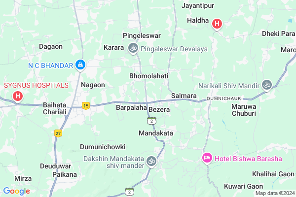
Lachit Gargh Map
EDIT Map
Add Your House
 ..
..
Current Corona Virus Infected Patients Count in Kamrup District
| City Name | District Name | Total Covid cases |
|---|---|---|
| Kamrup District | Kamrup | 1 |
Locality Name :
Lachit Gargh
( लाचित गर्गः )
Tehsil Name : Bezera
District : Kamrup
State : Assam
Language : Assamese and Bodo, Karbi, Rabha, Boro, Garo, Tiwa
Current Time 11:28 AM
Date: Wednesday , Feb 05,2025 (IST)
Time zone: IST (UTC+5:30)
Elevation / Altitude: 55 meters. Above Seal level
Telephone Code / Std Code: 0361
Assembly constituency : Jalukbari assembly constituency
Assembly MLA : Himanta Biswa Sarma
Lok Sabha constituency : Gauhati parliamentary constituency
Parliament MP : QUEEN OJA
Serpanch Name :
Pin Code : 781007
Post Office Name : Ulubari
Commodities Prices : Mawiong Regulated Market Market / Mandi
Rivers Near Lachit Gargh
Kopili
Khulsi River
Kopili
Khulsi River
About Lachit Gargh
Correct below Info and add more info about Lachit GarghLachit Gargh is a Village in Bezera Tehsil in Kamrup District of Assam State, India. It is located 34 KM towards East from District head quarters Goroimari. 26 KM from State capital Dispur
Lachit Gargh Pin code is 781007 and postal head office is Ulubari .
Lachit Gargh is surrounded by Bezera (Pt) Tehsil towards west , Kamalpur(Pt.) Tehsil towards west , Bihdia Tehsil towards North , Sipajhar Tehsil towards East .
Guwahati , Rangia , Dispur , Mangaldoi are the near by Cities to Lachit Gargh.
This Place is in the border of the Kamrup District and Darrang District. Darrang District Sipajhar is East towards this place . Also it is in the Border of other district Kamrup Metro .
Demographics of Lachit Gargh
Assamese is the Local Language here.Politics in Lachit Gargh
85.18% , Bharatiya Janata Party , 75974 , BJP , INC are the major political parties in this area.Polling Stations /Booths near Lachit Gargh
1)Bathan L.p School (r/w)2)Bazera Higher Secondary School (l/w)
3)Khairapara L.p School
4)Khehenipara Balika High School (l/w)
5)Rudreswar L.p School (r/w)
HOW TO REACH Lachit Gargh
By Rail
Baihata Rail Way Station is the very nearby railway stations to Lachit Gargh.Colleges near Lachit Gargh
Chhaygaon College
Address :
Fakuruddin Ali Ahmed College
Address :
Bpc College
Address :
Chhamaria Anchalik College
Address : Venue- Chamaria (kahibari)
Asom Sikshak Prasikshan Mahavidyalaya
Address : P.o.-lankeswar,dist.-kamrup,assam– 781014
Schools near Lachit Gargh
Sankar Dev Jatiya Vidyalaya
Address : bezera , karara , kamrup , Assam . PIN- 781121 , Post - Bezera
Bezera Hss
Address : bezera , karara , kamrup , Assam . PIN- 781121 , Post - Bezera
Kampith Vidya Mandir
Address : saraighat , karara , kamrup , Assam . PIN- 781121 , Post - Bezera
Udayan Santi Niketan
Address : bezera , karara , kamrup , Assam . PIN- 781121 , Post - Bezera
Govt Health Centers near Lachit Gargh
1) KHALIHOI SC (B) , KHALIHOI SC (B) , BAZANAPATHAR-KURUA SECTOR ,2) GANESH KUNWARI SC , GANESH KUNWARI SC , BAZANAPATHAR-KURUA SECTOR , NEAR GANESH MANDIR
3) DHEKIPARA SC , DHEKIPARA SC , Lawjan-Dumunichowki SD ,
Hospitals in Lachit Gargh,Bezera
Triveni Bandhar Homoeo Health Centre
Baihata Chariali; Kamrup; NH-15; Mangaldoi Road; Baihata; Baihata; Assam 781381; India
6.2 KM distance Detail
more ..
Petrol Bunks in Lachit Gargh,Bezera
Ms Danmel Sogani and Sons Assam Oil
Baihata Chariali; Kamrup; NH-31; Guwahati Road; Baihata; Baihata; Assam 781381; India
6.3 KM distance Detail
Kamalpur service station
381; Guwahati - Baihata Rd; Baihata; Assam 781380; India
7.2 KM distance Detail
more ..
Colleges in Lachit Gargh,Bezera
EXPOSURE EDUCATION
MONGOLDOI ROAD; BAIHATA CHARIALI; GUWAHATI; Assam 781381; India
6.2 KM distance Detail
A to Z Infotech; Professional Computer Institute
Niz-Madartola; Assam 781381; India
6.2 KM distance Detail
more ..
Local Parks in Lachit Gargh,Bezera
Sector 1 Township Park
Ramchai Hills; Ganesh Nagar; Noonmati; Guwahati; Assam 781004; India
19.2 KM distance Detail
Governement Offices near Lachit Gargh,Bezera
Nagaon Water Supply Board
Baihata Chariali; Kamrup; NH-31; Barpeta Road; Baihata; Baihata; Assam 781381; India
6.8 KM distance Detail
About Lachit Gargh &
History
How to reach Lachit Gargh
Tourist Places Near By Lachit Gargh
Schools in Lachit Gargh
Colleges in Lachit Gargh
Temperature & weather of Lachit Gargh
places in Lachit Gargh
Lachit Gargh photos
More Information
How to reach Lachit Gargh
Tourist Places Near By Lachit Gargh
Schools in Lachit Gargh
Colleges in Lachit Gargh
Temperature & weather of Lachit Gargh
places in Lachit Gargh
Lachit Gargh photos
More Information
Village Talk
Post News or Events about this Village
Near Cities
Guwahati 21 KM near
Rangia 22 KM near
Dispur 24 KM near
Mangaldoi 29 KM near
Guwahati 21 KM near
Rangia 22 KM near
Dispur 24 KM near
Mangaldoi 29 KM near
Near By Taluks
Bezera (Pt) 0 KM near
Bezera 0 KM near
Bihdia 11 KM near
Kamalpur(Pt.) 11 KM near
Bezera (Pt) 0 KM near
Bezera 0 KM near
Bihdia 11 KM near
Kamalpur(Pt.) 11 KM near
Near By Air Ports
Borjhar Airport 37 KM near
Shillong Airport 98 KM near
Salonibari Airport 121 KM near
Rupsi Airport 209 KM near
Borjhar Airport 37 KM near
Shillong Airport 98 KM near
Salonibari Airport 121 KM near
Rupsi Airport 209 KM near
Near By Tourist Places
Guwahati 25 KM near
Dispur 25 KM near
Mangaldai 29 KM near
Hajo 31 KM near
Nalbari 39 KM near
Guwahati 25 KM near
Dispur 25 KM near
Mangaldai 29 KM near
Hajo 31 KM near
Nalbari 39 KM near
Near By Districts
Darrang 30 KM near
Kamrup Metro 32 KM near
Kamrup 32 KM near
Baksa 36 KM near
Darrang 30 KM near
Kamrup Metro 32 KM near
Kamrup 32 KM near
Baksa 36 KM near
Near By RailWay Station
Guwahati Rail Way Station 21 KM near
Rangiya Junction Rail Way Station 22 KM near
Guwahati Rail Way Station 21 KM near
Rangiya Junction Rail Way Station 22 KM near