| Home | City Bus | Maps | Villages | Cities | Rail | Tourist Places | School | College | Pin Codes | Corona Cases Count |
| Distance Calculator Bus Services IFSC Codes Trace Mobile Number Weather Search Place Trace IP Available Cash ATM/Banks Locate Polling Booth Report an Error contact People |
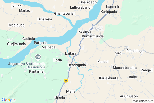
Chicherla Map
EDIT Map
Add Your House
 ..
..
Current Corona Virus Infected Patients Count in Kalahandi District
| City Name | District Name | Total Covid cases |
|---|---|---|
| Golamunda | Kalahandi | 1 |
| Kalahandi District | Kalahandi | 1 |
Locality Name :
Chicherla
( ଚି଼ଚେର୍ଲ )
Tehsil Name : Kesinga
District : Kalahandi
State : Odisha
Language : Oriya and Hindi,
Current Time 05:20 PM
Date: Wednesday , Feb 05,2025 (IST)
Time zone: IST (UTC+5:30)
Elevation / Altitude: 183 meters. Above Seal level
Telephone Code / Std Code: 06655
Assembly constituency : Bhawanipatna assembly constituency
Assembly MLA : anam naik
Lok Sabha constituency : Kalahandi parliamentary constituency
Parliament MP : BASANTA KUMAR PANDA
Serpanch Name :
Alternate Village Name : Chicharla
Commodities Prices : Kesinga Market / Mandi
Chicherla Live Weather
Temperature: 34.8 °C
clear sky
Humidity: 20%
Wind : 2.33 mt/sec towards NW
StationName : "Kesinga"
observed on 2 Hours Back
Temperature: 34.8 °C
clear sky
Humidity: 20%
Wind : 2.33 mt/sec towards NW
StationName : "Kesinga"
observed on 2 Hours Back
Chicherla Weather Forecast for Next 5 days
06-02-2025
22.3°C to 34.0°C
few clouds, broken clouds, overcast clouds
22.3°C to 34.0°C
few clouds, broken clouds, overcast clouds
07-02-2025
20.7°C to 35.2°C
clear sky, broken clouds, scattered clouds
20.7°C to 35.2°C
clear sky, broken clouds, scattered clouds
08-02-2025
20.7°C to 35.2°C
clear sky
20.7°C to 35.2°C
clear sky
09-02-2025
19.0°C to 34.1°C
clear sky
19.0°C to 34.1°C
clear sky
10-02-2025
17.3°C to 34.6°C
clear sky
17.3°C to 34.6°C
clear sky
National Highways Reachable To Chicherla
Nationa High Way :NH26
Nationa High Way :NH26
Rivers Near Chicherla
Dongadarha Nadi :Dongadarha Nadi
Kodobhāta Nadi :Kodobhata Nadi
Dongadarha Nadi :Dongadarha Nadi
Kodobhāta Nadi :Kodobhata Nadi
About Chicherla
Correct below Info and add more info about ChicherlaChicherla is a small Village/hamlet in Kesinga Tehsil in Kalahandi District of Odisha State, India. It is located 33 KM towards North from District head quarters Bhawanipatna. 322 KM from State capital Bhubaneswar
Chicherla is surrounded by Titlagarh Tehsil towards North , Narala Tehsil towards East , Bhawanipatna Tehsil towards South , Muribahal Tehsil towards North .
Titlagarh , Bhawanipatna , Kantabanji , Balangir are the near by Cities to Chicherla.
This Place is in the border of the Kalahandi District and Balangir District. Balangir District Titlagarh is North towards this place .
Demographics of Chicherla
Oriya is the Local Language here.Politics in Chicherla
BJP , BJD , INC are the major political parties in this area.Polling Stations /Booths near Chicherla
1)Laitara Ups2)Kholpala Ps
3)Kikia Cps
4)Degaon Ups
5)Kusumsila Ps
HOW TO REACH Chicherla
By Rail
Kesinga Rail Way Station , Kandel Road Rail Way Station are the very nearby railway stations to Chicherla.Pincodes near Chicherla
766011 ( Utkela ) , 767066 ( Kholan ) , 767033 ( Titilagarh )Colleges near Chicherla
Utkela Junior Mahavidyalaya
Address :
Kesinga Mahavidyalaya Kesinga Kalahandi Odisha
Address : At-kesinga Ps-kesinga Dist-kalahandi State-odiaha India
Schools near Chicherla
Kapileswar High School Kanteshir
Address : At-kanteshir po-kanteshir dist-kalahandi state-odiaha block-kesinga
Tundla High School,tundla
Address : At/PO:Tundla
VIA:Kesinga
Dist.:Kalahandi
State: Odisha
PIN:766012
Up-graded Govt High School Nunmath
Address :
Govt Health Centers near Chicherla
1) Udit Narayan Pur T.B Hospital , Kalahandi , Kalahandi , Kalahandi2) Lanjigarh Road SC , LANJIGARH ROAD , LANJIGARH ROAD , Near PHC (N) Lanjigarh road
3) SINAPALI , SINAPALI , SINAPALI ,
Hospitals in Chicherla,Kesinga
karim clinic&sanjivani diagnostic
Bhawanipatna - Balangir Hwy; Kesinga; Odisha 766012; India
4.0 KM distance Detail
more ..
Petrol Bunks in Chicherla,Kesinga
HP PETROL PUMP - B K FILLING STATION
Bhawanipatna - Balangir Highway; Kesinga; Odisha 766012; India
0.4 KM distance Detail
more ..
Colleges in Chicherla,Kesinga
NICE COMPUTER EDUCATION
NEAR BUDHADANGAR BUDHARAJA MANDIR; KESINGA; Kesinga; Odisha 766012; India
4.2 KM distance Detail
Govt. Women's College; Bhawanipatna.
National Highway 26; Jeypore - Bhawanipatna - Balangir - Bargarh Hwy; Junagarh; Odisha; India
10.4 KM distance Detail
more ..
Electronic Shops in Chicherla,Kesinga
Shree Shyam Motors;Kesinga
h; 26; North Ave; Shivaji Park; Punjabi Bagh; New Delhi; Delhi; India
1.8 KM distance Detail
About Chicherla &
History
How to reach Chicherla
Tourist Places Near By Chicherla
Schools in Chicherla
Colleges in Chicherla
Temperature & weather of Chicherla
places in Chicherla
Chicherla photos
More Information
How to reach Chicherla
Tourist Places Near By Chicherla
Schools in Chicherla
Colleges in Chicherla
Temperature & weather of Chicherla
places in Chicherla
Chicherla photos
More Information
Village Talk
Post News or Events about this Village
Near Cities
Titlagarh 17 KM near
Bhawanipatna 31 KM near
Kantabanji 51 KM near
Balangir 75 KM near
Titlagarh 17 KM near
Bhawanipatna 31 KM near
Kantabanji 51 KM near
Balangir 75 KM near
Near By Taluks
Kesinga 0 KM near
Titlagarh 13 KM near
Narala 18 KM near
Bhawanipatna 29 KM near
Kesinga 0 KM near
Titlagarh 13 KM near
Narala 18 KM near
Bhawanipatna 29 KM near
Near By Air Ports
Raipur Airport 212 KM near
Vishakhapatnam Airport 302 KM near
Bhubaneswar Airport 306 KM near
Rajahmundry Airport 413 KM near
Raipur Airport 212 KM near
Vishakhapatnam Airport 302 KM near
Bhubaneswar Airport 306 KM near
Rajahmundry Airport 413 KM near
Near By Tourist Places
Kalahandi 38 KM near
Phulbani 126 KM near
Mahasamund 174 KM near
Jeypore 177 KM near
Sambalpur 186 KM near
Kalahandi 38 KM near
Phulbani 126 KM near
Mahasamund 174 KM near
Jeypore 177 KM near
Sambalpur 186 KM near
Near By Districts
Kalahandi 31 KM near
Balangir 75 KM near
Nuapada 112 KM near
Sonepur 117 KM near
Kalahandi 31 KM near
Balangir 75 KM near
Nuapada 112 KM near
Sonepur 117 KM near
Near By RailWay Station
Kesinga Rail Way Station 4.9 KM near
Titlagarh Junction Rail Way Station 17 KM near
Kesinga Rail Way Station 4.9 KM near
Titlagarh Junction Rail Way Station 17 KM near