| Home | City Bus | Maps | Villages | Cities | Rail | Tourist Places | School | College | Pin Codes | Corona Cases Count |
| Distance Calculator Bus Services IFSC Codes Trace Mobile Number Weather Search Place Trace IP Available Cash ATM/Banks Locate Polling Booth Report an Error contact People |
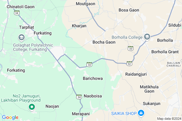
Bebejia Map
EDIT Map
Add Your House
 ..
..
Current Corona Virus Infected Patients Count in Jorhat District
| City Name | District Name | Total Covid cases |
|---|---|---|
| Jorhat District | Jorhat | 8 |
Locality Name :
Bebejia
( बैबेजीअ )
Tehsil Name : Titabor
District : Jorhat
State : Assam
Language : Assamese and Aiton, Shan, Burmese
Current Time 12:43 PM
Date: Monday , Apr 28,2025 (IST)
Time zone: IST (UTC+5:30)
Elevation / Altitude: 98 meters. Above Seal level
Telephone Code / Std Code: 0376
Assembly constituency : Golaghat assembly constituency
Assembly MLA : Ajanta Neog
Lok Sabha constituency : Kaliabor parliamentary constituency
Parliament MP : Gaurav Gogoi
Serpanch Name :
Pin Code : 785632
Post Office Name : Purana Titabor
Commodities Prices : Mangkolemba Market / Mandi
National Highways Reachable To Bebejia
Nationa High Way :NH702D
Nationa High Way :NH702D
Rivers Near Bebejia
Melak-Jhanji
Melak-Jhanji
Melak-Jhanji
Melak-Jhanji
About Bebejia
Correct below Info and add more info about BebejiaBebejia is a Village in Titabor Tehsil in Jorhat District of Assam State, India. It is located 44 KM towards South from District head quarters Jorhat. 17 KM from Titabor. 274 KM from State capital Dispur
Bebejia Pin code is 785632 and postal head office is Purana Titabor .
Borholla ( 10 KM ) are the nearby Villages to Bebejia. Bebejia is surrounded by Golaghat East Tehsil towards west , Golaghat Tehsil towards west , Golaghat North Tehsil towards North , Titabor Tehsil towards North .
Golaghat , Mariani , Jorhat , Wokha are the near by Cities to Bebejia.
This Place is in the border of the Jorhat District and Golaghat District. Golaghat District Kakodonga is North towards this place .
Bebejia Gaon 2011 Census Details
Bebejia Local Language is Assamese. Bebejia Gaon Village Total population is 150 and number of houses are 33. Female Population is 50.0%. Village literacy rate is 88.7% and the Female Literacy rate is 44.0%.
Population
| Census Parameter | Census Data |
| Total Population | 150 |
| Total No of Houses | 33 |
| Female Population % | 50.0 % ( 75) |
| Total Literacy rate % | 88.7 % ( 133) |
| Female Literacy rate | 44.0 % ( 66) |
| Scheduled Tribes Population % | 0.0 % ( 0) |
| Scheduled Caste Population % | 0.0 % ( 0) |
| Working Population % | 44.0 % |
| Child(0 -6) Population by 2011 | 13 |
| Girl Child(0 -6) Population % by 2011 | 38.5 % ( 5) |
Bebejia Gaon Census More Deatils.
Politics in Bebejia
Indian National Congress , BJP , AGP , 84.06% , 72704 , INC are the major political parties in this area.Polling Stations /Booths near Bebejia
1)Ratanpur Simanta M.e. School (r/s)2)Ghiladhari Sr. Basic School
3)Ghiladharibagan L.p. School (l/s)
4)Gazalasatra Jr. Basic School
5)Jamuguribagan Lp School (m)
HOW TO REACH Bebejia
By Rail
Oating Rail Way Station , Furkating Junction Rail Way Station are the very nearby railway stations to Bebejia.Colleges near Bebejia
Borholla College
Address :
Schools in Bebejia
Mihi Ram Saikia Hs
Address : bebejia , titabor , jorhat , Assam . PIN- 785632 , Post - Purana Titabor
Snehmayee Dutta Adarsha Jatiya Vid
Address : bebejia , titabor , jorhat , Assam . PIN- 785632 , Post - Purana Titabor
Govt Health Centers near Bebejia
1) Kachugaon SC , , , Near Temple2) Herheri SC , , Barpathar to Golaghat road ,
3) Bilgaon MPHC , , , Near Bilgaon railway station
Petrol Bunks in Bebejia,Titabor
Petrol pump Jabhrilal and Poshraj Filling Station
Titabor-Barhola-Nagabat Road; Golaghat; Borholla; Assam 785631; India
9.2 KM distance Detail
more ..
Colleges in Bebejia,Titabor
College Studio
Titabar-Borholla-Nagabat Rd; Shantipur; Golaghat; Borholla; Assam 785631; India
7.8 KM distance Detail
Borholla College
Titabor-Barhola-Nagabat Road; Golaghat; Borholla; Assam 785631; India
7.8 KM distance Detail
Lilawati Junior College
Barhola - Bosa Rd; Kanchan Nagar; Golaghat; Nangal Gaon; Assam 785631; India
7.8 KM distance Detail
Furkating College Departmental Building
Golaghat; Tarphat; Assam 785610; India
8.6 KM distance Detail
more ..
Local Parks in Bebejia,Titabor
Jyotimyee Children Park.
Magistrate Colony; Golaghat; Bhoga Gaon; Assam 785621; India
15.8 KM distance Detail
Police Stations near Bebejia,Titabor
Borholla Police Station
Titabor-Barhola-Nagabat Road; Golaghat; Borholla; Assam 785631; India
8.0 KM distance Detail
Barhola Tiniali
Titabor-Barhola-Nagabat Road; Golaghat; Borholla; Assam 785631; India
8.0 KM distance Detail
About Bebejia &
History
How to reach Bebejia
Tourist Places Near By Bebejia
Schools in Bebejia
Colleges in Bebejia
Temperature & weather of Bebejia
places in Bebejia
Bebejia photos
More Information
How to reach Bebejia
Tourist Places Near By Bebejia
Schools in Bebejia
Colleges in Bebejia
Temperature & weather of Bebejia
places in Bebejia
Bebejia photos
More Information
Village Talk
Post News or Events about this Village
Near Cities
Golaghat 14 KM near
Mariani 41 KM near
Jorhat 42 KM near
Wokha 46 KM near
Golaghat 14 KM near
Mariani 41 KM near
Jorhat 42 KM near
Wokha 46 KM near
Near By Taluks
Gomariguri 11 KM near
Golaghat East 11 KM near
Golaghat 14 KM near
Golaghat North 15 KM near
Gomariguri 11 KM near
Golaghat East 11 KM near
Golaghat 14 KM near
Golaghat North 15 KM near
Near By Air Ports
Rowriah Airport 40 KM near
Dimapur Airport 76 KM near
Lilabari Airport 107 KM near
Salonibari Airport 146 KM near
Rowriah Airport 40 KM near
Dimapur Airport 76 KM near
Lilabari Airport 107 KM near
Salonibari Airport 146 KM near
Near By Tourist Places
Jorhat 43 KM near
Wokha 46 KM near
Mokokchung 49 KM near
Majuli 65 KM near
Kaziranga National Park 70 KM near
Jorhat 43 KM near
Wokha 46 KM near
Mokokchung 49 KM near
Majuli 65 KM near
Kaziranga National Park 70 KM near
Near By Districts
Golaghat 14 KM near
Jorhat 42 KM near
Wokha 46 KM near
Mokokchung 54 KM near
Golaghat 14 KM near
Jorhat 42 KM near
Wokha 46 KM near
Mokokchung 54 KM near
Near By RailWay Station
Oating Rail Way Station 8.9 KM near
Furkating Junction Rail Way Station 9.1 KM near
Sarupathar Rail Way Station 37 KM near
Oating Rail Way Station 8.9 KM near
Furkating Junction Rail Way Station 9.1 KM near
Sarupathar Rail Way Station 37 KM near