| Home | City Bus | Maps | Villages | Cities | Rail | Tourist Places | School | College | Pin Codes | Corona Cases Count |
| Distance Calculator Bus Services IFSC Codes Trace Mobile Number Weather Search Place Trace IP Available Cash ATM/Banks Locate Polling Booth Report an Error contact People |
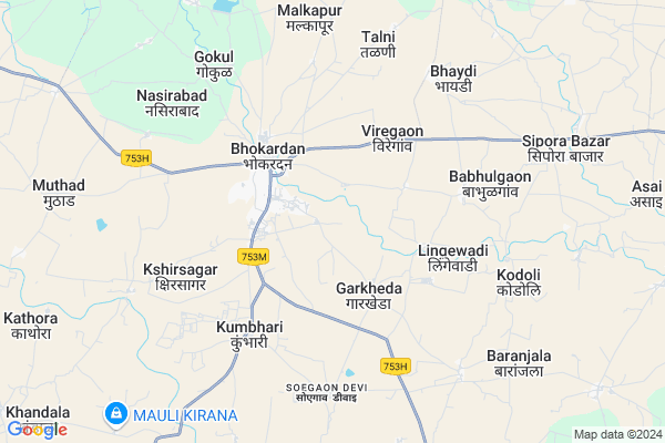
Fattepur
Fattepur Map
EDIT Map
Add Your House
 ..
..
Current Corona Virus Infected Patients Count in Jalna District
| City Name | District Name | Total Covid cases |
|---|---|---|
| Jalna District | Jalna | 4 |
Locality Name :
Fattepur
( फत्तेपूर )
Taluka Name : Bhokardan
District : Jalna
State : Maharashtra
Region : Marathwada
Division : Aurangabad
Language : Marathi
Current Time 12:41 PM
Date: Wednesday , Apr 30,2025 (IST)
Time zone: IST (UTC+5:30)
Elevation / Altitude: 523 meters. Above Seal level
Telephone Code / Std Code: 02485
Assembly constituency : Bhokardan assembly constituency
Assembly MLA : Santosh Raosaheb Danve
Lok Sabha constituency : Jalna parliamentary constituency
Parliament MP : Danve Raosaheb Dadarao
Serpanch Name :
Pin Code : 431114
Post Office Name : Bhokardan
Commodities Prices : Bhokardan Market / Mandi
Fattepur Live Weather
Temperature: 39.0 °C
clear sky
Humidity: 12%
Wind : 7.5 mt/sec towards NW
StationName : "Sillod"
observed on Now
Temperature: 39.0 °C
clear sky
Humidity: 12%
Wind : 7.5 mt/sec towards NW
StationName : "Sillod"
observed on Now
Fattepur Weather Forecast for Next 5 days
01-05-2025
31.4°C to 39.9°C
clear sky
31.4°C to 39.9°C
clear sky
02-05-2025
29.1°C to 40.0°C
clear sky, scattered clouds
29.1°C to 40.0°C
clear sky, scattered clouds
03-05-2025
28.8°C to 40.3°C
clear sky, few clouds
28.8°C to 40.3°C
clear sky, few clouds
04-05-2025
28.5°C to 39.6°C
scattered clouds, broken clouds, clear sky
28.5°C to 39.6°C
scattered clouds, broken clouds, clear sky
05-05-2025
25.3°C to 38.7°C
light rain, few clouds, clear sky, scattered clouds
25.3°C to 38.7°C
light rain, few clouds, clear sky, scattered clouds
Rivers Near Fattepur
Jivrakha
Purna :पूर्णा :पूर्णा
Jivrakha
Purna :पूर्णा :पूर्णा
About Fattepur
Correct below Info and add more info about FattepurFattepur is a Village in Bhokardan Taluka in Jalna District of Maharashtra State, India. It belongs to Marathwada region . It belongs to Aurangabad Division . It is located 51 KM towards North from District head quarters Jalna. 3 KM from Takali Bhokardan. 392 KM from State capital Mumbai
Fattepur Pin code is 431114 and postal head office is Bhokardan .
Bhaidi ( 3 KM ) , Takali Bhokardan ( 3 KM ) , Kumbhari ( 4 KM ) , Lingewadi ( 5 KM ) , Alapur ( 5 KM ) are the nearby Villages to Fattepur. Fattepur is surrounded by Jafrabad Taluka towards East , Sillod Taluka towards west , Phulambri Taluka towards west , Badnapur Taluka towards South .
Sillod , Soyagaon , Jalna , Malkapur are the near by Cities to Fattepur.
This Place is in the border of the Jalna District and Aurangabad District District. Aurangabad District District Sillod is west towards this place .
Fattepur 2011 Census Details
Fattepur Local Language is Marathi. Fattepur Village Total population is 2769 and number of houses are 572. Female Population is 49.7%. Village literacy rate is 55.3% and the Female Literacy rate is 22.0%.
Population
| Census Parameter | Census Data |
| Total Population | 2769 |
| Total No of Houses | 572 |
| Female Population % | 49.7 % ( 1377) |
| Total Literacy rate % | 55.3 % ( 1532) |
| Female Literacy rate | 22.0 % ( 608) |
| Scheduled Tribes Population % | 0.0 % ( 0) |
| Scheduled Caste Population % | 3.3 % ( 90) |
| Working Population % | 55.1 % |
| Child(0 -6) Population by 2011 | 465 |
| Girl Child(0 -6) Population % by 2011 | 52.5 % ( 244) |
Fattepur Census More Deatils.
Politics in Fattepur
Bharatiya Janata Party , BJP , NCP , INC are the major political parties in this area.Polling Stations /Booths near Fattepur
1)Z.p.p.s Dongaon 22)Z.p.p.s Fattepur
3)Z.p.p.s Javkheda Thenga
4)Z.p.p.s Mangrul
5)Z.p.p.s.ganeshpur
HOW TO REACH Fattepur
By Rail
There is no railway station near to Fattepur in less than 10 km. Jalna Rail Way Station (near to Jalna) are the Rail way stations reachable from near by towns.By Road
Bhokardan , Sillod , Jalna are the nearby by towns to Fattepur having road connectivity to FattepurColleges near Fattepur
S D Deshmukh College
Address :
Schools in Fattepur
Zpps Fattepur
Address : fattepur , bhokardan , jalna , Maharashtra . PIN- 431114 , Post - Bhokardan
Govt Health Centers near Fattepur
1) RH Bhokardan , Rural Hospital Bhokardan , Jalna Road,Bhokardan.Estate No 2253 ,2) Viregaon , Sub Center Viregaon , Viregaon , Viregaon
3) Babhulgaon , Sub Center Babhulgaon , At Post Babhulgaon , PHC Renukai Pimpalgaon
Petrol Bunks in Fattepur,Bhokardan
HP PETROL PUMP - SHRI GANPATI PETROLEUM
Survey NO 3 (part) Bhokardan Jafrabad Road; Bhokardan; Aurangabad; Maharashtra 431114; India
2.9 KM distance Detail
KIRAN P. DESHMUKH
Sillod - Bhokardan Road; Bhokardan; Maharashtra 431114; India
3.1 KM distance Detail
more ..
Schools in Fattepur,Bhokardan
Priyadarshani Indira Gandhi School & College
Bhokardan; Maharashtra 431114; India
2.5 KM distance Detail
About Fattepur &
History
How to reach Fattepur
Tourist Places Near By Fattepur
Schools in Fattepur
Colleges in Fattepur
Temperature & weather of Fattepur
places in Fattepur
Fattepur photos
More Information
How to reach Fattepur
Tourist Places Near By Fattepur
Schools in Fattepur
Colleges in Fattepur
Temperature & weather of Fattepur
places in Fattepur
Fattepur photos
More Information
Village Talk
Post News or Events about this Village
Near Cities
Sillod 17 KM near
Soyagaon 49 KM near
Jalna 49 KM near
Malkapur 52 KM near
Sillod 17 KM near
Soyagaon 49 KM near
Jalna 49 KM near
Malkapur 52 KM near
Near By Taluks
Bhokardan 2 KM near
Jafrabad 27 KM near
Sillod 31 KM near
Phulambri 40 KM near
Bhokardan 2 KM near
Jafrabad 27 KM near
Sillod 31 KM near
Phulambri 40 KM near
Near By Air Ports
Chikkalthana Airport 65 KM near
Nanded Airport 222 KM near
Gandhinagar Airport 233 KM near
Latur Airport 241 KM near
Chikkalthana Airport 65 KM near
Nanded Airport 222 KM near
Gandhinagar Airport 233 KM near
Latur Airport 241 KM near
Near By Tourist Places
Aurangabad 70 KM near
Grishneshwar 77 KM near
Burhanpur 113 KM near
Dhule 144 KM near
Washim 158 KM near
Aurangabad 70 KM near
Grishneshwar 77 KM near
Burhanpur 113 KM near
Dhule 144 KM near
Washim 158 KM near
Near By Districts
Jalna 49 KM near
Buldhana 59 KM near
Aurangabad District 69 KM near
Jalgaon 98 KM near
Jalna 49 KM near
Buldhana 59 KM near
Aurangabad District 69 KM near
Jalgaon 98 KM near
Near By RailWay Station
Jalna Rail Way Station 52 KM near
Aurangabad Rail Way Station 73 KM near
Jalna Rail Way Station 52 KM near
Aurangabad Rail Way Station 73 KM near