| Home | City Bus | Maps | Villages | Cities | Rail | Tourist Places | School | College | Pin Codes | Corona Cases Count |
| Distance Calculator Bus Services IFSC Codes Trace Mobile Number Weather Search Place Trace IP Available Cash ATM/Banks Locate Polling Booth Report an Error contact People |
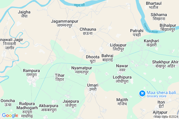
Dhoota
Dhoota Map
EDIT Map
Add Your House
 ..
..
Current Corona Virus Infected Patients Count in Jalaun District
| City Name | District Name | Total Covid cases |
|---|---|---|
| Jalaun District | Jalaun | 1 |
Locality Name :
Dhoota
( धूता )
Block Name : Rampura
District : Jalaun
State : Uttar Pradesh
Division : Jhansi
Language : Hindi and Urdu
Current Time 02:04 PM
Date: Monday , Apr 28,2025 (IST)
Time zone: IST (UTC+5:30)
Elevation / Altitude: 158 meters. Above Seal level
Telephone Code / Std Code: 05168
Assembly constituency : Madhogarh assembly constituency
Assembly MLA : Mool Chandra Singh
Lok Sabha constituency : Jalaun parliamentary constituency
Parliament MP : BHANU PRATAP SINGH VERMA
Serpanch Name :
Pin Code : 285124
Post Office Name : Jagammanpur
Alternate Village Name : Dhuta
Commodities Prices : Auraiya Market / Mandi
Rivers Near Dhoota
Kunwari
Yamuna :যমুনা :યમુના :यमुना :ಯಮುನಾ :यमुना :யமுனை :Ямуна :https://1drv.ms/b/s!Ar-WXIFaX7UdgQuO6WpVrTr6YYsQ
Kunwari
Yamuna :যমুনা :યમુના :यमुना :ಯಮುನಾ :यमुना :யமுனை :Ямуна :https://1drv.ms/b/s!Ar-WXIFaX7UdgQuO6WpVrTr6YYsQ
About Dhoota
Correct below Info and add more info about DhootaDhoota is a Village in Rampura Block in Jalaun District of Uttar Pradesh State, India. It belongs to Jhansi Division . It is located 30 KM towards North from District head quarters Orai. 1 KM from Rampura. 206 KM from State capital Lucknow
Dhoota Pin code is 285124 and postal head office is Jagammanpur .
Babupura ( 2 KM ) , Udotpura Jagir ( 2 KM ) , Chhauna ( 3 KM ) , Lidaupur ( 3 KM ) , Nawar ( 4 KM ) are the nearby Villages to Dhoota. Dhoota is surrounded by Madhogarh Block towards South , Kuthaund Block towards East , Chakarnagar Block towards North , Auraiya Block towards East .
Bhajanpura , Lahar , Achhalda , Orai are the near by Cities to Dhoota.
Dhoota 2011 Census Details
Dhoota Local Language is Hindi. Dhoota Village Total population is 1514 and number of houses are 238. Female Population is 45.1%. Village literacy rate is 62.5% and the Female Literacy rate is 23.5%.
Population
| Census Parameter | Census Data |
| Total Population | 1514 |
| Total No of Houses | 238 |
| Female Population % | 45.1 % ( 683) |
| Total Literacy rate % | 62.5 % ( 946) |
| Female Literacy rate | 23.5 % ( 356) |
| Scheduled Tribes Population % | 0.0 % ( 0) |
| Scheduled Caste Population % | 18.2 % ( 276) |
| Working Population % | 29.7 % |
| Child(0 -6) Population by 2011 | 225 |
| Girl Child(0 -6) Population % by 2011 | 45.3 % ( 102) |
Dhoota Census More Deatils.
Politics in Dhoota
BJP , SP , BSP , INC are the major political parties in this area.Polling Stations /Booths near Dhoota
1)Behrai2)Chhani
3)Dhaurpur
4)Rudavli
5)Manpura
HOW TO REACH Dhoota
By Rail
There is no railway station near to Dhoota in less than 10 km.Colleges near Dhoota
Samar Singh Intar College Rampura Jalaun U.p.
Address :
Pt. Parashuram Dwedi Mahavidhayala
Address :
Schools in Dhoota
Ups Dhuta
Address : dhuta , rampura , jalaun , Uttar Pradesh . PIN- 285124 , Post - Jagammanpur
Govt Health Centers near Dhoota
1) Patrahi , govt building , , out of village2) Nawar , govt building , , near sabji mandy
3) Jamarehi Sani , govt building , , out of village
Petrol Bunks in Dhoota,Rampura
Sai Krupa Filling Station Indian Oil
Gohan - Umri - Rampura Rd; Umari; Uttar Pradesh 285129; India
4.3 KM distance Detail
Monu Sengar
rampura petrol pump; Rampura-Jagammanpur Rd; Rampura; Uttar Pradesh; India
7.8 KM distance Detail
more ..
Colleges in Dhoota,Rampura
Pt. Parashuram Dwivedi College
Jagammanpur; Jagammanpur; Jalaun; Uttar Pradesh 285124; India
6.1 KM distance Detail
more ..
Schools in Dhoota,Rampura
Junior School (Talab Wala) Litawali
near Litawali Talab ;Litawali(; Lutauli; Uttar Pradesh 285124; India
3.3 KM distance Detail
S.S.V. Shiksha Niketan Lidaupur-Litawali
Biloha road lidaupur-; Lutauli; 285124; India
3.5 KM distance Detail
Local Parks in Dhoota,Rampura
Atar Baba Ki Bagiya
Litauli-nahar pul road; Lutauli; Uttar Pradesh 285124; India
3.5 KM distance Detail
About Dhoota &
History
How to reach Dhoota
Tourist Places Near By Dhoota
Schools in Dhoota
Colleges in Dhoota
Temperature & weather of Dhoota
places in Dhoota
Dhoota photos
More Information
How to reach Dhoota
Tourist Places Near By Dhoota
Schools in Dhoota
Colleges in Dhoota
Temperature & weather of Dhoota
places in Dhoota
Dhoota photos
More Information
Village Talk
Post News or Events about this Village
Near Cities
Bhajanpura 9 KM near
Lahar 39 KM near
Achhalda 46 KM near
Orai 52 KM near
Bhajanpura 9 KM near
Lahar 39 KM near
Achhalda 46 KM near
Orai 52 KM near
Near By Taluks
Rampura 1 KM near
Madhogarh 13 KM near
Kuthaund 18 KM near
Chakarnagar 22 KM near
Rampura 1 KM near
Madhogarh 13 KM near
Kuthaund 18 KM near
Chakarnagar 22 KM near
Near By Air Ports
Gwalior Airport 114 KM near
Kanpur Airport 129 KM near
Kheria Airport 173 KM near
Amausi Airport 188 KM near
Gwalior Airport 114 KM near
Kanpur Airport 129 KM near
Kheria Airport 173 KM near
Amausi Airport 188 KM near
Near By Tourist Places
Kannauj 114 KM near
Bithur 117 KM near
Gwalior 120 KM near
Kanpur 121 KM near
Datia 123 KM near
Kannauj 114 KM near
Bithur 117 KM near
Gwalior 120 KM near
Kanpur 121 KM near
Datia 123 KM near
Near By Districts
Jalaun 29 KM near
Auraiya 31 KM near
Etawah 56 KM near
Bhind 56 KM near
Jalaun 29 KM near
Auraiya 31 KM near
Etawah 56 KM near
Bhind 56 KM near
Near By RailWay Station
Phaphund Rail Way Station 45 KM near
Bharthana Rail Way Station 47 KM near
Phaphund Rail Way Station 45 KM near
Bharthana Rail Way Station 47 KM near