| Home | City Bus | Maps | Villages | Cities | Rail | Tourist Places | School | College | Pin Codes | Corona Cases Count |
| Distance Calculator Bus Services IFSC Codes Trace Mobile Number Weather Search Place Trace IP Available Cash ATM/Banks Locate Polling Booth Report an Error contact People |
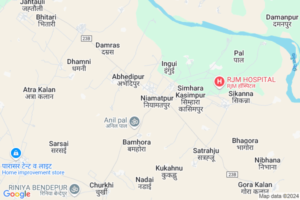
Niamatpur
Niamatpur Map
EDIT Map
Add Your House
 ..
..
Current Corona Virus Infected Patients Count in Jalaun District
| City Name | District Name | Total Covid cases |
|---|---|---|
| Jalaun District | Jalaun | 1 |
Locality Name :
Niamatpur
( न्यामतपुर )
Block Name : Maheva
District : Jalaun
State : Uttar Pradesh
Division : Jhansi
Language : Hindi and Urdu
Current Time 11:43 AM
Date: Monday , Apr 28,2025 (IST)
Time zone: IST (UTC+5:30)
Elevation / Altitude: 129 meters. Above Seal level
Telephone Code / Std Code: 05164
Assembly constituency : Kalpi assembly constituency
Assembly MLA : Vinod Chaturvedi
Lok Sabha constituency : Jalaun parliamentary constituency
Parliament MP : BHANU PRATAP SINGH VERMA
Serpanch Name :
Alternate Village Name : Nayamatpur
Commodities Prices : Kalpi Market / Mandi
Niamatpur Live Weather
Temperature: 35.5 °C
clear sky
Humidity: 15%
Wind : 2.43 mt/sec towards S
StationName : "KÄ\u0081lpi"
observed on 2 Hours Back
Temperature: 35.5 °C
clear sky
Humidity: 15%
Wind : 2.43 mt/sec towards S
StationName : "KÄ\u0081lpi"
observed on 2 Hours Back
Niamatpur Weather Forecast for Next 5 days
29-04-2025
29.7°C to 41.2°C
clear sky
29.7°C to 41.2°C
clear sky
30-04-2025
27.0°C to 42.4°C
few clouds, overcast clouds, scattered clouds, clear sky
27.0°C to 42.4°C
few clouds, overcast clouds, scattered clouds, clear sky
01-05-2025
29.0°C to 41.8°C
clear sky
29.0°C to 41.8°C
clear sky
02-05-2025
28.8°C to 42.0°C
scattered clouds, overcast clouds, broken clouds, clear sky
28.8°C to 42.0°C
scattered clouds, overcast clouds, broken clouds, clear sky
03-05-2025
27.3°C to 41.0°C
scattered clouds, broken clouds, clear sky, few clouds, light rain
27.3°C to 41.0°C
scattered clouds, broken clouds, clear sky, few clouds, light rain
National Highways Reachable To Niamatpur
Nationa High Way :NH519
Nationa High Way :NH519
Rivers Near Niamatpur
Yamuna :যমুনা :યમુના :यमुना :ಯಮುನಾ :यमुना :யமுனை :Ямуна :https://1drv.ms/b/s!Ar-WXIFaX7UdgQuO6WpVrTr6YYsQ
Sengur
Yamuna :যমুনা :યમુના :यमुना :ಯಮುನಾ :यमुना :யமுனை :Ямуна :https://1drv.ms/b/s!Ar-WXIFaX7UdgQuO6WpVrTr6YYsQ
Sengur
About Niamatpur
Correct below Info and add more info about NiamatpurNiamatpur is a Village in Maheva Block in Jalaun District of Uttar Pradesh State, India. It belongs to Jhansi Division . It is located 26 KM towards East from District head quarters Orai. 6 KM from Mahewa. 181 KM from State capital Lucknow
Abhedipur ( 2 KM ) , Bamhori Khurd ( 2 KM ) , Kandaki Rihi Mustakil ( 3 KM ) , Bamhora ( 3 KM ) , Sareni Mustakil ( 4 KM ) are the nearby Villages to Niamatpur. Niamatpur is surrounded by Rajpur Block towards North , Jalaun Block towards west , Kuthaund Block towards North , Amrodha Block towards East .
Orai , Pukhrayan , Bhajanpura , Achhalda are the near by Cities to Niamatpur.
This Place is in the border of the Jalaun District and Kanpur Dehat District. Kanpur Dehat District Rajpur is North towards this place .
Niamatpur 2011 Census Details
Niamatpur Local Language is Hindi. Niamatpur Village Total population is 3708 and number of houses are 638. Female Population is 46.7%. Village literacy rate is 64.9% and the Female Literacy rate is 24.2%.
Population
| Census Parameter | Census Data |
| Total Population | 3708 |
| Total No of Houses | 638 |
| Female Population % | 46.7 % ( 1731) |
| Total Literacy rate % | 64.9 % ( 2406) |
| Female Literacy rate | 24.2 % ( 899) |
| Scheduled Tribes Population % | 0.0 % ( 0) |
| Scheduled Caste Population % | 17.0 % ( 629) |
| Working Population % | 37.0 % |
| Child(0 -6) Population by 2011 | 537 |
| Girl Child(0 -6) Population % by 2011 | 46.0 % ( 247) |
Niamatpur Census More Deatils.
Politics in Niamatpur
BJP , SP , BSP , INC are the major political parties in this area.Polling Stations /Booths near Niamatpur
1)Devpura2)Niwadi
3)Noorpur
4)Nyamatpur
5)Nyamatpur
HOW TO REACH Niamatpur
By Rail
There is no railway station near to Niamatpur in less than 10 km.Pincodes near Niamatpur
285130 ( Madaripur ) , 285123 ( Jalaun Town ) , 209115 ( Rajpur (Kanpur Dehat) )Colleges near Niamatpur
Msv Inter College
Address :
Schools near Niamatpur
Rajkiy U. Madhamik School
Address : musmariya , maheva , jalaun , Uttar Pradesh . PIN- 285128 , Post - Hadrukh
Nehru Audyaugik Inter College
Address : sarsai , maheva , jalaun , Uttar Pradesh . PIN- 285133
Ups Himmatpur
Address : himmatpur , maheva , jalaun , Uttar Pradesh . PIN- 285123 , Post - Jalaun Town
Ups Pithaupur
Address : pithaupur , maheva , jalaun , Uttar Pradesh . PIN- 285130 , Post - Madaripur
Govt Health Centers near Niamatpur
1) Nyamatpur , , ,2) Pukhrayan , , ,
3) Churkhi , , ,
Petrol Bunks in Niamatpur,Maheva
BHADAURIA FILLING STATION
NIYAMATPUR; SIMARA CHOURAH; JALAUN; Uttar Pradesh 285001; India
13.4 KM distance Detail
Krishna Filling Center
Near Sai Mandir; Usargaon; Jalaun; Uttar Pradesh; India
21.6 KM distance Detail
more ..
Colleges in Niamatpur,Maheva
B.B. Degree Collage
Urkara Khurda Marg; Abhedipur; Uttar Pradesh 285130; India
2.8 KM distance Detail
Smt Amrit Kunwar Mahavidyalaya
Atra Kalan; Jalaun district; Orai; Uttar Pradesh 285001; India
8.8 KM distance Detail
more ..
Schools in Niamatpur,Maheva
Thakur Phool Singh Serbind Singh Public School
Nayamatpur; dist. Jaloun; Uttar Pradesh; India
1.2 KM distance Detail
Super Markets in Niamatpur,Maheva
Annat Provision Store
village & post; Shahjahanpur; Shahjahanpur; Kalpi; Uttar Pradesh 285202; India
17.6 KM distance Detail
About Niamatpur &
History
How to reach Niamatpur
Tourist Places Near By Niamatpur
Schools in Niamatpur
Colleges in Niamatpur
Temperature & weather of Niamatpur
places in Niamatpur
Niamatpur photos
More Information
How to reach Niamatpur
Tourist Places Near By Niamatpur
Schools in Niamatpur
Colleges in Niamatpur
Temperature & weather of Niamatpur
places in Niamatpur
Niamatpur photos
More Information
Village Talk
Post News or Events about this Village
Near Cities
Orai 29 KM near
Pukhrayan 33 KM near
Bhajanpura 47 KM near
Achhalda 64 KM near
Orai 29 KM near
Pukhrayan 33 KM near
Bhajanpura 47 KM near
Achhalda 64 KM near
Near By Taluks
Maheva 6 KM near
Rajpur 18 KM near
Jalaun 22 KM near
Kuthaund 23 KM near
Maheva 6 KM near
Rajpur 18 KM near
Jalaun 22 KM near
Kuthaund 23 KM near
Near By Air Ports
Kanpur Airport 99 KM near
Gwalior Airport 147 KM near
Amausi Airport 163 KM near
Khajuraho Airport 178 KM near
Kanpur Airport 99 KM near
Gwalior Airport 147 KM near
Amausi Airport 163 KM near
Khajuraho Airport 178 KM near
Near By Tourist Places
Kanpur 92 KM near
Bithur 94 KM near
Kannauj 114 KM near
Datia 138 KM near
Sonagir 145 KM near
Kanpur 92 KM near
Bithur 94 KM near
Kannauj 114 KM near
Datia 138 KM near
Sonagir 145 KM near
Near By Districts
Jalaun 25 KM near
Auraiya 32 KM near
Kanpur Dehat 49 KM near
Hamirpur District 73 KM near
Jalaun 25 KM near
Auraiya 32 KM near
Kanpur Dehat 49 KM near
Hamirpur District 73 KM near
Near By RailWay Station
Kalpi Rail Way Station 25 KM near
Orai Rail Way Station 30 KM near
Kalpi Rail Way Station 25 KM near
Orai Rail Way Station 30 KM near